Including Arthog Waterfalls.
From Cardiff, take the A470 to Dolgellau. From Dolgellau, turn left off the A470 onto the A493 and follow it to Arthog. At Arthog, after passing a church with a graveyard on the right, take the first right, down a gated lane. Just before the lane passes over a dismantled railway line, park in the gated parking area to the left. SH 6403 1478.
Walk back along the lane towards the main road, then cross a ladder stile on the left onto a dike. Follow the dike away from the road, until it reaches a stone wall. Turn right, following the wall along the edge of the graveyard, to the road. Turn left on the road, then immediately turn right onto a footpath. The Arthog Waterfalls lie below the path, and many of them can only be seen from here in winter, when there are no leaves on the trees. The path climbs up to a track. Continue ahead on the track, then take the path that branches off ahead-right, before the track crosses the river.
The cascades continue upstream from the bridge. Continue until the path climbs away from the river, then heads back to rejoin it (where there are several more waterfalls tucked in a little gorge), crossing stiles as needed. Once you reach a stone footbridge over the river, the waterfalls have ended, and you can head back.
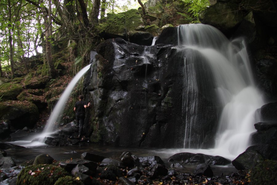
The lower waterfalls below the track used to have a dedicated path but this has been left to decay and become overgrown. Parts of it can still be followed by experienced visitors. Follow the track over the river, turning left onto another track, then out onto a road. Continue ahead along the road. A short way down the road, a gated path to the left leads down to the edge of the river, where the remains of the path can be followed to see the lowest and tallest of the waterfalls, where two separate streams drop into the same plunge pool. Parts of the path may be considered too badly damaged to follow. It's posible that this path is now in private hands, and you should seek permission. Return the same way.
| Waterfall | Grid reference | GPS coordinates | Image |
|---|---|---|---|
| Arthog Waterfalls | SH 64759 14323 | 52.709623°N, 4.003285°W | |
Whilst every care has been taken in the compilation of this description, neither the author nor his fellow walkers can accept responsibility for loss or injury arising from any errors, omissions or inaccuracies in this description. This description is intended as a guide only, and you should select a route to suit your own abilities, at your own discretion. Ability requirements are a guide only. Route maps are approximated. You follow this description at your own risk.