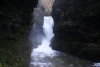
Looking for waterfall walks in Wales? There are 144 route guides to choose from below, and there are also galleries covering each of the waterfalls I have visited. If you're just looking for somewhere to get started, I would suggest the Four Waterfalls and Elidir Trail walks in Waterfall Country, part of the Fforest Fawr mountain range in the Brecon Beacons National Park, in South Wales - by far the most popular place for waterfall walks in Wales. For the others, pick a route guide or gallery, and get walking.
Each route guide may be graded either completely or in parts, using the following grading system:
None
May be visited without needing any countryside walking ability at all, such as where waterfalls are clearly visible from a road, or have a specially prepared all-access trail.
Beginner
Route follows established paths (or roads), without any major hazards. Suitable for most beginners, but may not be suitable for mobility impaired visitors. Some level of countryside walking ability is required.
Moderate
Route follows established paths or walking routes that need additional ability, or may present some hazards, such as a path that ascends a small rock outcrop, passes over exposed drops, or fords a large stream.
Experienced
Route may follow paths that have become badly overgrown, or not follow paths at all. River crossings may be required. Hazards may be significant.
Expert
Route presents extreme hazards, such as scrambles over unprotected drops, very tricky ascents/descents, or falling debris. Mistakes could easily have severe consequences.
Not graded
Route has not been graded.
Map reading
Map reading skills and an appropriate map are required (may be used in combination with any of the other grades).
Rivers and streams will always present some natural hazards (pools, small drops, etc.), and children should always be supervised. Icy conditions will always increase the severity of any hazard, and can turn even a beginner walk into an expert walk. Grades do not cover routes behind waterfalls unless specifically mentioned in the route guides. These grades are intended as a guide only, and you should always use your own discretion.
This page is intended to cover natural waterfalls, not weirs. As a result, sites like the Big Wood Weir (SJ 29837 49506) in Plas Power Woods, the Horseshoe Falls (SJ 19549 43352) on the River Dee, the Cup and Saucer Waterfall (SJ 32448 48392) at Erddig, Felin Newydd Falls (SN 69294 79417) on the Afon Rheidol, Dolanog Falls (SJ 06745 12660) on the Afon Efyrnwy, Pwll y Ddar (SN 88119 06205) on the River Neath, Sgwd Penllergaer/Penllergaer Waterfall (SS 62474 98958) on the Afon Llan, Y Rhaeadr Dirgel/Y Rhaeadr Gudd/The Secret Waterfall (SH 69924 47254) on the Afon Barlwyd and the rather impressive Bryn Eglwys Quarry Waterfall/Snowdonia's Secret Waterfall (SH 69587 05347) created by slate quarrying on the Nant Gwernol are intentionally ignored.
It is also intended to cover actual waterfalls, not rapids or waves in a river. As a result, sites that are relevant only to canoeists are intentionally ignored. Sites where a house has been named as a waterfall, perhaps due to its proximity to a minor feature in a nearby stream, are also ignored. Examples include Rhaiadr Wnion/Afon Rhaiadr (SH 77715 20299) near Rhydymain and Rhaeadr-du (SH 94698 08628) on Nant Rhaeadr near Llyn Gwyddior. Waterfalls that are merely coincidental to a nearby named feature are not covered, unless the waterfall forms a major part of the feature - this means that many named crags that have small waterfalls nearby are not covered. Examples include Graig Fawr (SH 92546 08236) above Clegyrnant near Llyn Gwyddior.
It is also intended to cover only places where significant amounts of water can be seen to fall, or smaller amounts manage to fall continuously for very long distances. As a result, many ice climbing routes are ignored, as are small streams that tumble down scarps for long distances without breaking into proper waterfalls (such as those in Cwm Idwal).
It is also intended to cover only surface waterfalls, or waterfalls that are on the surface for part of their descent. There are many hundreds of spectacular named underground waterfalls, ranging to at least 30 metres high for single drops (big examples include Swamp Creek in Ogof Ffynnon Ddu and Awe Chasm in Ogof Draenen), and at least 75 metres for multiple drops (such as Pwll Dwfn). These are all intentionally excluded from these listings.
Waterfalls are like fractals; the more detail you look in, the more little waterfalls you will see. Virtually every single mountain stream will have some little waterfalls. The idea of this page is to collect the waterfalls that are really worthy of notice. The general approach used for determining this was:
If the waterfall is marked on the 1:25'000 maps, and has either a name or a tourist attraction symbol on any scale of map (preferably 1:25'000 minimum).
If the waterfall is marked on both the 1:50'000 maps and the 1:25'000 maps, and appears to be an important feature of the area.
If the waterfall offers some particularly interesting or unique feature.
Any particularly tall waterfalls.
Any waterfalls that were recommended by relevant or personal sources.
Any other waterfalls encountered while visiting a more significant one.
There are, of course, limitless possibilities, and several areas with many waterfalls have not been covered due to the constraints given above. Examples would include the streams draining the northern scarps of the Brecon Beacons.
Finally, yes, I may have missed important waterfalls that fall into these categories. If you know of one, please contact me using the details on the homepage.
Glossary
The following Welsh words are commonly used when naming waterfalls - they can also follow normal Welsh mutations:
Afon (plural; afonydd)
River.
Berw
Boiling.
Ceunant (plural; ceunentydd)
Gorge.
Carreg (plural; cerrig)
Stone.
Craig, Graig (plural; creigiau)
Crag or rock.
Cwm (plural; cymoedd/cymau)
Valley.
Ddu, Du
Black.
Ffrwd (plural; ffrydiau)
Torrent or stream.
Gwyn, Wyn, Gwen, Wen
White.
Llyn (plural; llynnoedd/llynau)
Lake.
Nant (plural; nentydd)
Stream.
Pistyll (plural; pistylloedd)
Spout waterfall, horsetail waterfall or (rare) spring.
Pwll (plural; pyllau)
Pool.
Rhaeadr (plural; rhaeadrau)
Waterfall or cascade. Sometimes written as "rayadr", "rhayadr", "rhaiadr" or "rhayader", but all of these are now considered incorrect.
Sgwd (plural; sgydiau)
Waterfall or cascade. Sometimes written as "sgŵd" or incorrectly as "scwd" or "scŵd".
Some of these words change meaning in various Welsh dialects. For example, on the Llŷn Peninsula, "nant" generally means valley, "ffrwd" exclusively means stream, and "lli" or "llifeiriant" are used to mean torrent (elsewhere, those words generally mean flooding). The translations given here are the meanings typically intended in the naming of the waterfalls.
 List of all Welsh waterfalls covered by these routes and galleries, including grid references and pictures
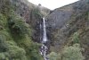 List of the tallest waterfalls in Wales
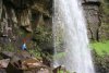 Waterfalls you can walk behind
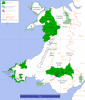 Searcheable overview map of the Welsh waterfalls covered by these routes and galleries
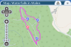 Detailed map of all the waterfalls and walk routes (note; all routes are approximated, and may contain inaccuracies - see the route guides below for more details of the routes)
 Download all walk routes as KML (note; all routes are approximated, and may contain inaccuracies - see the route guides below for more details of the routes)
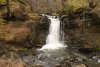 Gallery: Cwm Gwrelych 2016; covering Sgwd Clun Gwyn, Sgwd Isaf Clun Gwyn
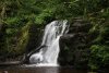 Gallery: Falls Revisited 2009; covering Sgwd Isaf Clun Gwyn
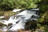 Gallery: Four Waterfalls 2009; covering Sgwd Clun Gwyn, Sgwd Isaf Clun Gwyn, Sgwd y Pannwr, Sgwd yr Eira/Upper Cilhepste Falls, Cilhepste Falls/Lower Cilhepste Falls, The Sheep Dip
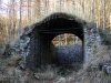 Gallery: Pontneddfechan Gunpowder Works 2008; covering an unnamed Afon Mellte waterfall
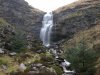 Gallery: Waterfalls 2008; covering Ogof Tarddiant Hepste, Sgwd yr Eira/Upper Cilhepste Falls, Cilhepste Falls/Lower Cilhepste Falls
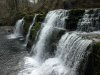 Gallery: Wales 2008 - Waterfall Country; covering Sgwd Clun Gwyn, Sgwd Isaf Clun Gwyn, Sgwd y Pannwr, Sgwd yr Eira/Upper Cilhepste Falls
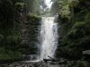 Gallery: Waterfalls 2004-2005; covering Sgwd Clun Gwyn, Sgwd Isaf Clun Gwyn, Sgwd y Pannwr, Sgwd yr Eira/Upper Cilhepste Falls
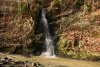 Gallery: Beside the Falls 2015; covering Sgwd Gwladus/Lady Falls/Idiot's leap, Sgwd Einion Gam
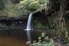 Gallery: Elidir Trail 2011; covering Pump Pwll, Sgwd Gwladus/Lady Falls/Idiot's leap, Craig Cilfach-bronwydd, Sgwd Einion Gam, Horseshoe Falls/Sgwd y Bedol, Sgwd Ddwli Isaf, Sgwd Ddwli
 Gallery: White Water 2010; covering Cwm Pwll-y-Rhyd
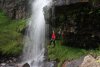 Gallery: Behind Waterfalls 2009; covering Sgwd Ddwli, Sgwd Ddwli Isaf
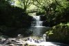 Gallery: Secluded Falls 2009; covering Sgwd Einion Gam, unnamed upper Afon Pyrddin waterfalls
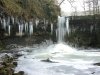 Gallery: Frozen Waterfalls 2009; covering Pump Pwll, Sgwd Gwladus/Lady Falls/Idiot's leap, Sgwd Einion Gam
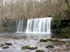 Gallery: Nedd Fechan Waterfalls 2008; covering Pump Pwll, Sgwd Gwladus/Lady Falls/Idiot's leap, Horseshoe Falls/Sgwd y Bedol, Sgwd Ddwli Isaf, Sgwd Ddwli
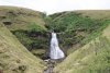 Gallery: The Rough With The Smooth 2010; covering Pwll-Du, Pwll Milast-fach
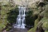 Gallery: North Brecon Beacons Waterfalls 2009; covering Afon Llia, Dog Pool
 Gallery: From Valleys to Mountains 2013; covering Sgwd Henrhyd
 Nant Llech 2009
 Gallery: Henrhyd 2006; covering Sgwd Henrhyd
 Gallery: Crossing Fforest Fawr 2010; covering partial Nant y Llyn
 Gallery: Southern Roundup 2010; covering Joe's Waterfall, Nant Tawe Fechan Falls
 Gallery: Winter Waters 2010; covering Sgwd Ddu
 Gallery: Southern Waterfalls 2009; covering Afon Twrch
 Gallery: In The Temperate Rainforest 2012; covering Garwnant Waterfall
 Gallery: Nant Crew and Nant Ddu 2009; covering Nant Crew, Nant Ddu
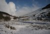 Gallery: Snowy Expanse 2010; covering waterfalls on Craig y Fro and Nant y Gerdinen
 Gallery: The Brecon Beacons in Snow 2009; covering waterfalls on Craig y Fro and Nant y Gerdinen
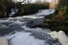 Gallery: Bach Howey and Glyn Tarell 2009; covering waterfalls on Afon Tarell, Nant y Gerdinen, Blaen Taf Fawr and tributaries
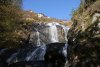 Gallery: Northern Waterfalls 2009 - Round V; covering waterfalls on Nant y Gerdinen
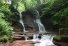 Gallery: Pwll-y-Wrach 2009; covering waterfalls on Craig y Fro and Nant y Gerdinen
 Gallery: Nant y Glais and Pontsarn 2009; covering Pontsarn Blue Pool/Pwll Glas
 Gallery: Eastern Beacons 2010; covering upper Nant Bwrefwr, Torpantau Falls
 Gallery: Wales 2008 - The Brecon Beacons; covering upper Nant Bwrefwr
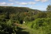 Gallery: Southeast Beacons 2015; covering Button's Waterfall, Cwm Dyar Waterfalls, Pwll Rhys, Pwll Crochan/Clydach Lower Waterfall, Devil's Waterfall/Pwll Cwn
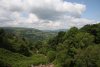 Gallery: Llanelly Hill Circuit 2009; covering Button's Waterfall, Cwm Dyar Waterfalls, The Polo Mint, Clydach Tributary Waterfalls, Cwm Nantmelyn Waterfall, Pwll Rhys
 Gallery: Wales 2008 - Heritage Trail; covering Devil's Waterfall/Pwll Cwn
 Llangatwg 2009
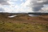 Gallery: Little Wales 2012; covering Pen Pych Waterfall/Berw Wion, Berw Nant yr Ychen/Virgin Falls
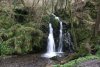 How The West Was Won 2010
 Glyncorrwg 2009
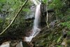 Gallery: Blaenant y Gwyddyl 2010; covering Blaenant y Gwyddyl
 In The Wild 2009
 Aberdulais Falls 2009
 Western Waterfalls 2009
 The Edge Of Alteration 2012
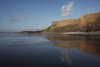 Southerndown 2011
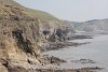 Southerndown 2010
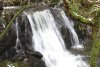 Gallery: Hell's Pools 2010; covering Dwfr Ddisgynfa Cwm-du
 Gallery: Ffynone 2012; covering Ffynone Waterfall, partial Cenarth Falls
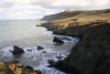 Gallery: Secret Waters 2011; covering Glangraig Waterfall
 Gallery: SENTA 2010; covering Pwll Ffrwd
 Beacon Hill 2009
 Gallery: Northern Waterfalls 2009 - Round III; covering Water Break-its-neck/Dŵr-Torri-Gwddf - Black Brook
 Gallery: Nant Feinion 2016; covering Ffrwd Fawr - Nant Feinion
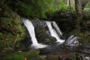 Gallery: Northern Waterfalls 2009 - Round IV; covering Nant Gwynllyn Falls
 Gallery: Pumlumon 2009; covering Rhaeadr Gwy, Nant y Sarn Falls
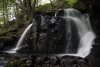 Gallery: Northern Waterfalls 2009 - Round II; covering Ciloerwynt Lower Falls
 Gallery: Cliffs, Crags and Cataracts 2010; covering Grogwynion Falls, Nant y Berws Falls
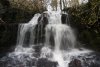 Gallery: Northern Waterfalls 2009 - Round VI; covering Rhaeadr Peiran/Peiran Falls, Mossy Seat Falls/Rhaeadr 'Mossy Seat', Nant y Gwaith Falls, Nant Cwm-du Falls, Nant y Cae Falls
 Gallery: Mid Wales 2008; covering Mynach Falls/Rhaeadr Mynach, Devil's Punchbowl/Crochan y Diafol, Gyfarllwyd Falls, Nant Bwa-drain
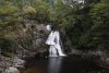 Gallery: Northern Waterfalls 2009 - Round I; covering Craig y Pistyll
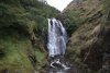 Gallery: Snowdonia 2009 - Waterfalls; covering Ffrwd Fawr - Afon Twymyn
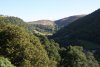 Gallery: Llangollen 2011; covering Glyn Diffwys
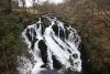 Gallery: Northern Roundup 2010; covering Afon Ceiriog
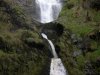 Wales 2008 - Water
 Gallery: Welsh Blue Skies 2012; covering partial Arthog Waterfalls
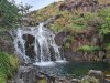 Gallery: Waterfalls Reprise 2024; covering Pistyll Cain, Rhaeadr Mawddach
 Gallery: Snowdonia 2007 - Cymoedd; covering Rhaeadr Cwm Dyli
 Gallery: Eastern Carneddau 2011; covering Fairy Glen
 Gallery: Snowdonia 2007 - Flooding; covering Swallow Falls/Rhaeadr Ewynnol, Pont-y-Pair Falls
 Gallery: Snowdonia 2009 - Glyderau Scrambling; covering Devil's Kitchen/Twll Du, Devil's Appendix