
Including Salmon Pool and Craig Pwll-du.
From Cardiff, take the A470 to Brecon. From Brecon, take the fourth turnoff at the roundabout, along the A40 to the next roundabout. Take the second turnoff, along the A470. When the A470 turns left off the current road, take it, and follow it to the T-junction at its end. Turn left again to remain on the A470. After just over 2.5 miles, turn right onto a narrow lane, signposted to Llanstephan, which immediately crosses a very narrow suspension bridge. (The junction comes without any warning, but the A470 will have recently passed the turning to Trericket Mill on the left.) Turn left at the next junction. When the road crosses a bridge over the Bachawy/Bach Howey river, park in a lay-by. SO 1063 4285.
The waterfalls in this gorge have no paths to reach them. They are protected by 30-40 metre cliffs, and even simple mistakes when locating the waterfalls could be serious. This is one area that should only be visited by expert visitors. My own access route to these waterfalls was compromised by starting on the wrong bank, and I have not visited them from the relatively safer bank, which is what I will describe here. As a result, I cannot give precise directions, and the final approach route is left as an exercise to the reader. Map reading skills are essential, and so is the ability to know when the map does not reflect reality, which frequently happens here. In many cases, new forestry tracks are missing from the map, and in the worst case, the map does not show any cliffs in places where the cliffs are dangerously tall. The forestry was being actively logged during my visit, and new tracks were being constructed. There may now be other tracks in addition to the ones mentioned here.
A footpath begins at a stile from the lay-by by the bridge. Take the footpath into a field, and turn right to locate the path that emerges from under the road bridge. Follow it to the left, initially just inside the woodland, then zigzaging up to the southeast end of the Ciliau farm. Ignore side tracks that leave on the right and left beside the farm, and walk through the farmyard, to continue on the track heading roughly northwards on the other side - that is the same direction as you were using to walk past all of the farm buildings. After 250 metres, the track turns sharp right at a junction. When the track turns left into a field 100 metres later, continue ahead into another field instead, following the hedge line ahead in roughly the same direction. At the far end of the field, the path passes into the field on the right. Continue ahead along the same hedge line, to gain a track at the end of the field, which passes into the next field on the left. Continue ahead with the hedge line (now turned a little to the left), along the edge of this field and the next few fields, to reach a very obvious major track running left-to-right.
Turn right on this new track. It passes a thin line of trees at the end of the field on the right, where the track bends to the left, then after running along a field without a fence on the right side of the track, it reaches the edge of the forestry land (the trees may not have regrown since being felled, and if so it's important to locate the line where the forest used to be). The forestry edge should be lined by a fence heading down into the valley (a bearing of roughly 202°, which is shown on the 1:25'000 scale OS Explorer map). Cross the fence into the forestry land and follow that fence line down to the valley. When the fence and forestry edge turns right, continue ahead, holding the same bearing as before. Cross any new forestry tracks (not marked on the map, and left to decay, so they may not be recognisable), watching out for those cliffs just up ahead.
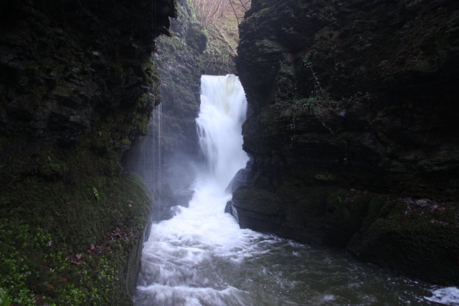
In the valley below is a large gorge. To the right are 30 metre cliffs. To the left are 40 metre cliffs. Ahead is the only part of the gorge that does not have tall cliffs, where the river runs in a semi-circle around the large sloping bank (which has smaller cliffs only for its central portion). The route should at this point be near the top of that bank. By following the right edge of the sloping bank down (close to the 30 metre cliffs), it's possible to reach the Salmon Pool waterfall. Ascend the bank again, and descend the other side, near to the 40 metre cliffs. Near the bottom, locate a ledge running on the left cliff (looking upstream) a few metres above the river, and find a place where you can get onto it. Follow the ledge into the gorge. Just before it runs out is the viewpoint for the very dramatic Craig Pwll-du waterfall.
There is another set of waterfalls upstream, though they lack the drama of the previous two. To reach them, go all the way back up to the major track you used at the top of the forestry (not the new forestry track). Turn left and follow the track all the way around to the Penisarplwyf farm. Ignore the tracks on the left at the farm, and walk ahead past the farm buildings into the farm yard. Just after the last building on the right is a path heading diagonally to the right between hedges (it may be fenced off - find a way to get onto the path). Follow the path to enter a large, roughly triangular field. Continue ahead to the far point of that field, then follow the stream and hedge line on the right all the way down to the river, where there is a footbridge just upstream. Find a place to descend to the waterfalls, which lie on the junction of the small stream and the river. For the best view, it is perhaps better to cross the bridge and approach from the far bank (such as descending beside the little stream that joins from the far bank downstream of the bridge), but watch out for the small cliffs beside the waterfalls.
You can return using the same paths and tracks. If you prefer a change of scenery, it's also possible to use tracks on the other side of the river. Be warned that the maps show paths that no longer exist, and you should avoid the path that used to run through the valley's woodland. From the far side of the footbridge, ascend the bank to the hedges that line the fields above. Follow these to the right (downstream). Just after crossing a small tributary stream (which has its waterfall immediately below), enter the field on the left - this is a public right of way but there may not be an obvious way into the field. Walk upstream along the right bank of the little tributary stream, to a gateway into the next field ahead.
Ahead-left, at the head of the tributary stream, is the Pwllperran farm, and the public right of way passes through another little field to reach the farm. However, the field layouts have changed, so the easiest way is to head a little to the right of the farm, through a gateway onto a track. (To the left, the track leads back to the farm.) Turn right on the track, and stay with it as it becomes grassed over, then clips the corner of the valley's forestry (which may have been felled or regrowing - tracks will exist which are not shown on the maps). At this point, take the forestry track heading ahead-right into the forest - you may need to leave the grassed-over track to locate it. It quickly joins a forestry track on a hairpin bend. Continue ahead, and follow the forestry track as it descends towards the bottom of the far end of the valley. It passes some tracks on the right, then a more substantial track climbing on the left, then a track doubling back on the right some time later. Just before the track breaks out into open fields ahead, take the final track that doubles back to the right. It soon turns left (with an overgrown track to the right on the corner), resuming the descent almost to the bottom of the valley. It then climbs a little to break out into open fields. Follow the edge of the valley's woodland (keeping the valley's trees on on your right) to reach the trees above the road. Descend the corner of the open field to the road. Turn right to get to the start of the walk.
| Waterfall | Grid reference | GPS coordinates | Image |
|---|---|---|---|
| Salmon Pool | SO 11928 43477 | 52.082616°N, 3.286673°W | |
| Craig Pwll-du | SO 12103 43552 | 52.083318°N, 3.284139°W | |
Whilst every care has been taken in the compilation of this description, neither the author nor his fellow walkers can accept responsibility for loss or injury arising from any errors, omissions or inaccuracies in this description. This description is intended as a guide only, and you should select a route to suit your own abilities, at your own discretion. Ability requirements are a guide only. Route maps are approximated. You follow this description at your own risk.