Including Nant Bwrefwr, the Blaen-y-Glyn/Caerfanell waterfalls and Torpantau Falls.
From Cardiff, take the A470 to the end of Merthyr Tydfil. From Merthyr Tydfil, take the A465 towards Abergavenny, then almost immediately take the first exit. At the staggered junction with the A4054, continue ahead-right. Follow the road through Pontsticill, and turn left when the road ahead shows as a dead-end, near the end of the reservoir. Take the next right, beyond the end of the second (Pentwyn) reservoir. Follow the road up to a pass. The upper parking area is along a dirt track to the left just after the summit of the pass. SO 0551 1749. The lower parking area is 1 km beyond it on the left, at the bottom of the steep hill. SO 0631 1704.
There is a choice of two main routes, easy and moderate, with a moderate extension and a hard extension. The easy route misses out on most of the waterfalls. The moderate extension picks up two extras that the moderate route misses out on, and the hard extension picks up a further two sets of waterfalls, including the largest on the river. To see all of the waterfalls, follow the moderate extension, then moderate route, then hard extension. For the moderate, moderate extension and hard extension routes, start at the upper parking area. For the easy route, start at the lower parking area.
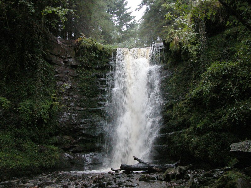
The easy route starts from the lower parking area as an easy walk up the left bank of the river (most of the waterfalls are badly obscured, but many will be seen later). Not long after Nant Bwrefwr joins from the left the path swings hard left, and a poor quality path continues ahead, beside a stile to the right. Stop here, and try to see the waterfall ahead. Then return to the last proper track that branched off on the right (it's now on the left), and follow it to the main Blaen-y-Glyn waterfall (sometimes referred to as Caerfanell Falls). Cross the bridge in front of the waterfall, and turn right on the other side. Follow the side of the river downstream to reach the road. Turn right on the road, cross the river, then turn right into the lower parking area.
The moderate extension is to head up along the right side of the Nant Bwrefwr stream from the upper parking area, up to the top of the fenced section, to see the first three sets of waterfalls (the lowest is a double waterfall, visible from the parking area). Then turn around and return to the parking area.
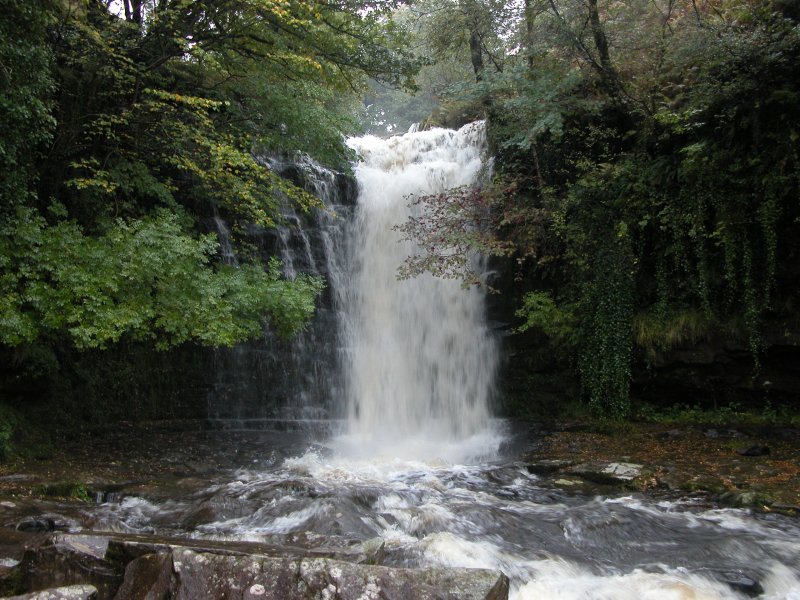
The moderate route heads down the left side of the Nant Bwrefwr stream from the upper parking area, past many more sets of waterfalls (the best of which is tucked out of sight part way down, and needs a short detour back up the stream to see it) to reach the main path at the bottom. There is another waterfall on the other side of the path. Turn left, then take a branch to the right to the base of the main Blaen-y-Glyn waterfall (sometimes referred to as Caerfanell Falls). Cross the bridge, and turn right. Head downstream past a few waterfalls, until the one that has a man-made weir at its top. Turn around and head back up past the main waterfall, keeping the river on your left. Follow the path all the way to the top waterfall, which is a little over 1 km upstream of the main waterfall in a narrow gorge, and is the only one that is about the same height as the main waterfall. Now you can choose which route to follow.
There are three routes from here, one of which is the hard extension (described below). If you only want to return to the parking area, either return the way you came, or if the river level and your river-crossing ability allows it, ford the river upstream of the waterfall and pick up a poorly defined path leading away from the river on the far bank, heading slightly downstream. After branching away from the river for about 75 metres, it reaches a junction with the larger main path. Turn left and follow the path to the edge of the forestry. Pick up an obvious track leading into the forestry, follow it until it swings left to reach a junction with a larger track. Turn right to reach the parking area.
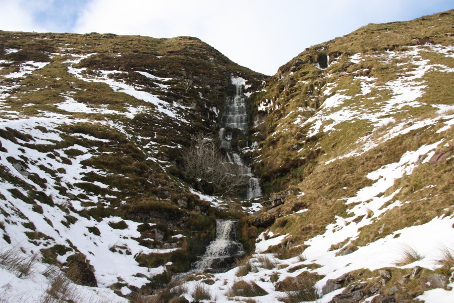
Alternatively, from the last waterfall on the moderate route, continue along the hard extension. This is as hard as you choose to make it. Leave the river, heading up the right bank, away from the waterfall (there is no path). Pick up a fairly well defined path running parallel to the river, about 200 metres from it. Turn left, following the path as it slowly swings left to cross a stream, before reaching the river again. Along this route, you should get some partially obscured views of the largest waterfall; Torpantau Falls, tumbling down the steep scarp on the left in a series of cascades - this can be little more than a trickle in low flow, but fills out nicely in higher flow. If the river level is too high for you, return the way you came. Otherwise, ford the river at the obvious crossing. The path then splits. If you're happy with the views you already got of Torpantau Falls, turn left and left again, gaining the main path heading back along the river (the same one used to get back to the forestry - see the paragraph above).
If you want a better look at Torpantau Falls, continue ahead-right, taking your pick of the multiple sheep tracks that then head to the right. Once you have reached the main Blaen Caerfanell stream, continue along its left bank for as much as 1km, passing some smaller waterfalls, to arrive at the foot of the main Torpantau Falls. Return to the ford, then take the route from the ford back to the forestry, and from there to the parking area (see the last paragraph for the moderate route).
| Waterfall | Grid reference | GPS coordinates | Image |
|---|---|---|---|
| Nant Bwrefwr | SO 05878 17408 | 51.847307°N, 3.367782°W | |
| Caerfanell Falls/Blaen-y-Glyn | SO 06080 17466 | 51.847862°N, 3.364866°W | |
| Torpantau Falls | SO 05128 19192 | 51.863215°N, 3.379157°W | |
Whilst every care has been taken in the compilation of this description, neither the author nor his fellow walkers can accept responsibility for loss or injury arising from any errors, omissions or inaccuracies in this description. This description is intended as a guide only, and you should select a route to suit your own abilities, at your own discretion. Ability requirements are a guide only. Route maps are approximated. You follow this description at your own risk.