

Including Berw Nant yr Ychen, Pen Pych Waterfall/Berw Wion, Nant Melyn Waterfall, Nant Carnfoesen Waterfall, Rhondda Fawr Waterfall and Nant y Gwair Falls.
From Cardiff, take the A470 to the end of Merthyr Tydfil. From Merthyr Tydfil, take the A465 to the left towards Hirwaun, follow it over the hill, and down to the next roundabout. Take the second turnoff to the next roundabout. Take the first turnoff and continue up to the top of the hill on the A4061, passing a viewpoint on the right. Follow the road down a couple of hairpin bends into Blaenrhondda. Take the second road to the right, and follow it for 1 km. Turn left just after a section of road with no houses on the left, and then left again at the next junction. When the road forks, turn right into the Penpych Woodland Park, then double back to the right into the parking area. SS 9222 9902.
The first part of this walk is relatively easy, and makes a nice short walk. The second part must not be underestimated. It is a tough walk, and is very poorly maintained. Good footwear is essential. Good visibility is also needed. High water levels are good for most of it, but bad for the part near Nant Melyn and Nant Carnfoesen. Take care when walking around above the crags of Pen Pych, as there are occasional deep fractures in the ground, which must be avoided.
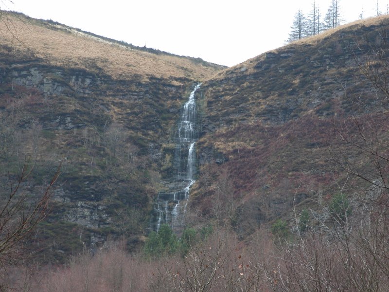
Take the very easy track from the end of the parking area, which zigzags at first before climbing steadily. Berw Nant yr Ychen can be seen on a distant cliff through gaps in the trees. The track ends at a fenced viewpoint, with a small waterfall below it, and the tall Pen Pych Waterfall/Berw Wion ahead. A smaller stepped path continues over a tall cascade between those two waterfalls, to the base of the Pen Pych Waterfall/Berw Wion. It then swings right and climbs up to the top of the cliff. For the easy walk, turn around at the base of the Pen Pych Waterfall/Berw Wion. (To the left at the top of the cliff is a path over the head of Nant yr Ychen, over to the next stream. Upstream are several of the smaller Nant y Gwair Falls, but these should only be accessed by expert visitors. Downstream are a couple of larger waterfalls that are in extremely risky, exposed locations. The first may be viewed with great care from above by expert visitors, but the second should not be viewed from here, even by experts.)
Continue following the path around the edge of the cliff that runs around the Pen Pych buttress. Stay near the cliff edge, taking a right fork when the path splits, some way after Pen Pych. After crossing the remains of a stone wall, take another right fork, descending through forestry. When the path reaches a junction with another proper path, turn left, heading a little uphill, and follow it until it descends to a substantial metal bridge over the Rhondda Fawr. On the other side of the bridge is a junction of paths.
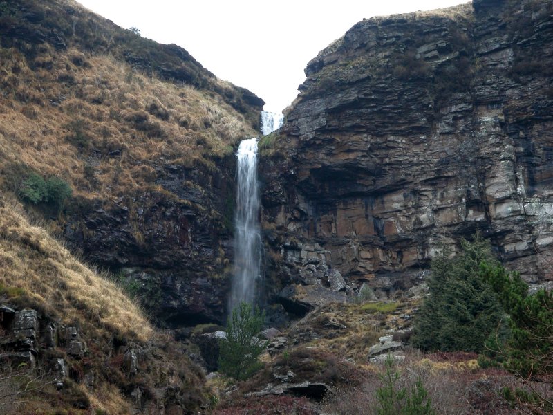
Turn left and follow the path to a junction of two streams. Cross the stream just upstream of the junction where a metal pipe acts as a bridge (take care in high water). Head up the right side of the other stream and cross a bridge, just before a tiny reservoir. Head up the left side of the reservoir above a deteriorating wall, and follow what remains of a path along the left side of the stream up to the Nant Melyn waterfall.
It is possible to see the Nant Carnfoesen waterfall from the path, but for the best view, cross the stream just upstream of the tiny reservoir, and head up the left bank of the other stream that enters the reservoir. Follow it up to the waterfall - there is no real path.
When you're done, return to the substantial metal bridge, and continue past it along a path running near the edge of a cliff. Take a small path that forks off on the right, and descends to the base of the Nant Drysiog waterfall, at a junction of poorly-defined paths; one ahead, one doubling back hard to the right, and one leading down ahead-right.
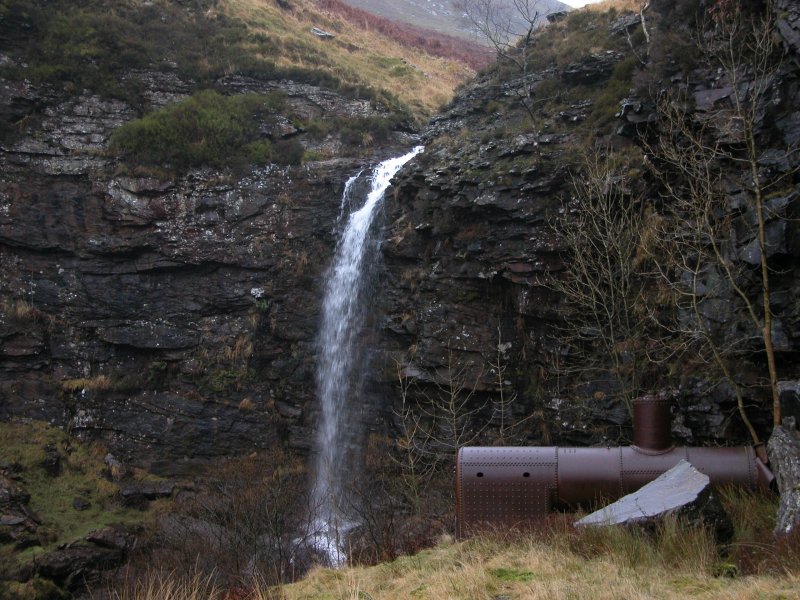
Take the path that doubles back on the right, and follow it to the main Rhondda Fawr waterfall, beside an old steam engine boiler, and disused mine level - there are several more little cascades below it, most of which can be seen best from the path. Return to the junction of paths.
Head down to the right past one more waterfall on Nant Drysiog hidden behind a concrete pipe, to another one hidden below the buildings below it - it can be tricky getting into a good viewpoint for this one.
Take the obvious track/road heading along the edge of the valley, starting at the buildings. Follow it for a long way, continuing ahead (middle track) at a junction of tracks, until it reaches the edge of Blaenrhondda, and becomes a more substantial road. Turn left when it ends at a junction, pass a road on the left, then turn right at the next two junctions to cross the river. Turn left at the next junction. Take a path to the right some way along here, which leads back to the parking area (or stay with the road, turning right as needed, to get back to the parking area).
Optionally, the second path that forks to the left inside the initial forest (at the start of the walk) steadily descends to some cascades. Beyond there, it reaches the next stream, where there are a couple of little spout waterfalls downstream, reachable with care by experienced walkers. Upstream, experienced walkers can reach several more, each being passable by very carefully ascending the slope on one side a little way before it (the left side is generally easier). Upstream of these is the base of the immense Berw Nant yr Ychen waterfall. After reaching the step of the waterfall with a large undercut, it becomes much more serious - do not continue beyond here. The upper steps can be seen from the main walk anyway, so it's not worth the risk.
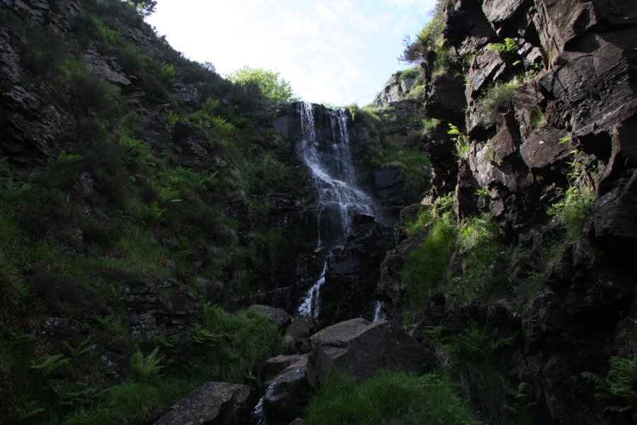
Optionally, to view the bottom of Nant y Gwair Falls, expert visitors can use the following route. Start at the parking area, and walk down the lane to leave it. Before joining the road, take the second lane to the right, running along the edge of the stream. Follow it as it deteriorates into a track, then becomes a path through the park (ignore a path to the left that tries to cling to the stream, and instead stay on the path that runs about 50 metres away from the stream through the park). Eventually the stream swings right, and the path is forced to cross it by a bridge. Cross the stream, and take the path that runs as close to the stream as possible, as the valley grows around it. Eventually the path dies out. Continue fighting upstream through the undergrowth, up several little cascades, to reach the largest of the waterfalls, pouring down the unstable crags. Take care.
| Waterfall | Grid reference | GPS coordinates | Image |
|---|---|---|---|
| Berw Nant yr Ychen/Virgin Falls | SS 91587 99230 | 51.681334°N, 3.569489°W | |
| Pen Pych Waterfall/Berw Wion | SS 91801 99709 | 51.685680°N, 3.566543°W | |
| Nant Melyn Waterfall | SN 91691 01584 | 51.702511°N, 3.568717°W | |
| Nant Carnfoesen Waterfall | SN 91713 01768 | 51.704169°N, 3.568456°W | |
| Rhondda Fawr Waterfall | SN 92246 01519 | 51.702034°N, 3.560669°W | |
| Nant y Gwair Falls | SS 90971 98747 | 51.676874°N, 3.578244°W | |
Whilst every care has been taken in the compilation of this description, neither the author nor his fellow walkers can accept responsibility for loss or injury arising from any errors, omissions or inaccuracies in this description. This description is intended as a guide only, and you should select a route to suit your own abilities, at your own discretion. Ability requirements are a guide only. Route maps are approximated. You follow this description at your own risk.