Including Sgwd yr Argoed.
From Cardiff, take the A470 to the end of Merthyr Tydfil. From Merthyr Tydfil, take the A465 to the left towards Hirwaun, follow it over the hill, and down to the next roundabout. Take the second turnoff, remaining on the A465, to the next roundabout. Take the second turnoff onto the A465 dual carriageway. At the next roundabout, take the first turnoff (left) into Blaewngwrach. Turn right at the mini-roundabout, then turn left just after the Dunraven pub onto Heol-y-Felin. Park near the school. SN 8687 0524.
Although large parts of this route can be followed without much difficulty, the waterfalls are located in unfortunate positions, hidden from easy sight. It may help to wait until the undergrowth has died back before visiting.
Continue up Heol-y-Glyn, which rapidly deteriorates into a dirt track. Just after passing the last house, another track branches off on the right. Follow the right track for 500 metres to a fork in the path, where the path to the right climbs steeply beside some cascades, and the track ahead leads to some abandoned mining buildings. A hidden stream flows in a culvert from the mining buildings to join the main stream by the path junction. Take the steep path to the right, which is the remains of a tramway incline. A large weir is hidden in the forest to the right, and can be visited by pushing through the undergrowth.
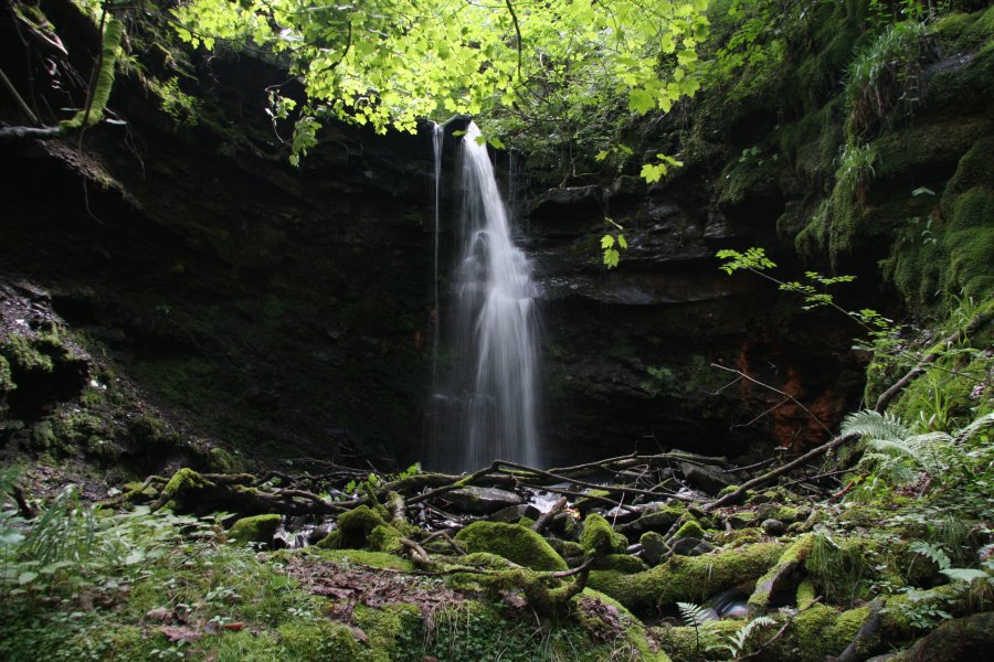
At the top of the incline, go through the gate, then look for a path heading up to the right, which becomes a track running along the right edge of the field, breaking out into the open beneath the Rhigos Mountains. The track swings left then right, before running beside the fence of another field on the right. Follow the track until you reach a gateway into the field on the right, then go through the gateway and head across the field to roughly the centre of its far side, at the top of the forested main stream valley. Descend really carefully into the valley, taking it slowly and watching out for crags and hidden drops. Head slowly upstream to Sgwd yr Argoed (which lies almost directly under the upstream corner of the field), and the taller inlet waterfall beside it.
Return to the track, and follow it to the right, taking the right path when it splits, to arrive at the Blaengwrach Farm. Just behind the farm, a track heads to the right. After passing the back of the farm on that track, follow the left side of the fence that heads over to the stream valley. From there, a poorly defined path crosses a fence and follows the left side of another fence to drop down to the stream at the head of a waterfall. View it from above.
Return to the main track past Blaengwrach Farm, and follow it as it zigzags and bends left. It then continues in roughly that new direction, passing some other tracks, and turning some sharp corners, to arrive at some settlement tanks. These may be fenced off and gated to prevent access, as all that lies beyond them is an active opencast mine. Instead, backtrack to the last stream (Nant Pen-y-cae), and follow it downstream until you are below the settlement tanks (don't go too far downstream, as it develops a significant gorge). Then turn right, heading away from the stream, crossing the open land below the settlement tanks, to reach the Nant Selar stream. Locate somewhere to cross it, and ascend the far bank to the edge of the trees that line the stream. Follow the valley downstream until it joins the Nant Pen-y-cae. You should be able to see the next waterfall at the junction, but take care when approaching it to avoid the steep sides.
Continue downstream, staying near the top of the Nant Pen-y-cae valley for another 100 metres, and try to locate and descend the path that zigzags down into the valley near to a small breeched dam, opposite a 20 metre inlet waterfall on the far bank. (If you reach an inlet stream or cliff edge on your own bank before you locate the zigzagging path, you have just gone too far.) Head downstream to reach the abandoned mining buildings, then follow the track back to the start of the walk.
| Waterfall | Grid reference | GPS coordinates | Image |
|---|---|---|---|
| Sgwd yr Argoed | SN 87304 04323 | 51.726263°N, 3.633060°W | |
Whilst every care has been taken in the compilation of this description, neither the author nor his fellow walkers can accept responsibility for loss or injury arising from any errors, omissions or inaccuracies in this description. This description is intended as a guide only, and you should select a route to suit your own abilities, at your own discretion. Ability requirements are a guide only. Route maps are approximated. You follow this description at your own risk.