

Including Rhondda Fawr Waterfall, Nant Melyn Waterfall and Nant Carnfoesen Waterfall. For those who need a little more adventure.
From Cardiff, take the A470 to the end of Merthyr Tydfil. From Merthyr Tydfil, take the A465 to the left towards Hirwaun, follow it over the hill, and down to the next roundabout. Take the second turnoff to the next roundabout. Take the first exit and continue up to the top of the hill on the A4061, passing a viewpoint on the right. When the land begins to drop away into the Rhondda valley, park in a parking area on the left. SN 9222 0208.
This walk was an official route, but must not be underestimated. It is a tough walk, and is very poorly maintained. Good footwear is essential. Good visibility is also needed. High water levels are good for the first half, and bad for the second half. The bracken can make route finding harder in summer.
Cross the road from the parking area, go through the gateway, and turn left onto a track, past some old remains of houses. Follow the track as it steepens, until a small cascade on the left signifies the second stream crossing the path (it may be almost dry in summer). Take the almost invisible stepped path that runs down the left side of the stream - it's badly overgrown, and difficult to follow. Stay beside the stream as it joins another, and swings left. A little way before the stream plunges over a cliff, take a path to the left (ignore the shortcut path to the right, as it bypasses several waterfalls). The path leads down to the base of the Nant Drysiog waterfall. Cross the waterfall outlet, to a junction of poorly-defined paths; one diagonally up to the right, one continuing ahead, and one leading down to the left.
Take a quick detour down to the left to see one more waterfall on Nant Drysiog hidden behind a concrete pipe, and another one hidden below the buildings below it - it can be tricky getting into a good viewpoint for this one. Return to the junction of paths.
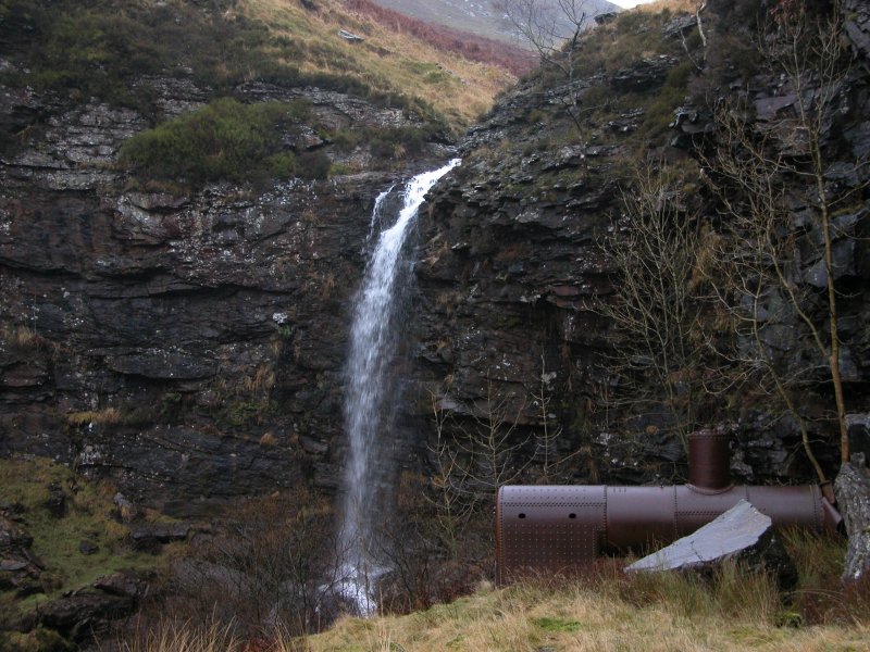
Take the path that continued ahead, and follow it to the main Rhondda Fawr waterfall, beside an old steam engine boiler, and disused mine level - there are several more little cascades below it, most of which can be seen best from the path. Return to the junction of paths.
Take the path that was diagonally up to the right (now doubling back up to the left), and follow it to a junction with another path (to the right is the other end of the shortcut). Turn left and follow the path past a bridge to a junction of two streams. Cross the stream just upstream of the junction where a metal pipe acts as a bridge (take care in high water). Head up the right side of the other stream and cross a bridge, just before a tiny reservoir. Head up the left side of the reservoir above a deteriorating wall, and follow what remains of a path along the left side of the stream up to the Nant Melyn waterfall.
It is possible to see the Nant Carnfoesen waterfall from the path, but for the best view, cross the stream just upstream of the tiny reservoir, and head up the left bank of the other stream that enters the reservoir. Follow it up to the waterfall - there is no real path.
When you're done, return to the metal pipe bridge, cross it, and turn left. Stay on the right bank of the stream, along the remains of a path made from stone slabs. Just past a set of cascading inlets, the path doubles back to the right, and climbs up to a fence with a gate. There are a few small cascades visible further up the stream. Head through the gate, and continue across the field, approximately perpendicular to the fence, to arrive back at the gateway and parking area. There is no clearly defined path over the field.
| Waterfall | Grid reference | GPS coordinates | Image |
|---|---|---|---|
| Rhondda Fawr Waterfall | SN 92246 01519 | 51.702034°N, 3.560669°W | |
| Nant Melyn Waterfall | SN 91691 01584 | 51.702511°N, 3.568717°W | |
| Nant Carnfoesen Waterfall | SN 91713 01768 | 51.704169°N, 3.568456°W | |
Whilst every care has been taken in the compilation of this description, neither the author nor his fellow walkers can accept responsibility for loss or injury arising from any errors, omissions or inaccuracies in this description. This description is intended as a guide only, and you should select a route to suit your own abilities, at your own discretion. Ability requirements are a guide only. Route maps are approximated. You follow this description at your own risk.