Including Fairy Glen.
From Cardiff, take the A470 to Conwy. From Conwy, take the A55 Westbound (initially signposted to Conwy). At junction 16, take the first turnoff (left) signposted to Penmaenmawr. Immediately take the first left, signposted to Dwygyfylchi. After passing The Gladstone pub, pass a private access lane on the right, then take the next proper road to the right. Continue ahead at the staggered crossroads, then turn left at the end of the road. Follow the road to Capelulo, and turn right onto the tiny lane immediately before The Fairy Glen pub. After 100 yards, park in the gravel parking area on the right. SH 7440 7648.
(Note that this walk includes the Fairy Glen ex-attraction near Conwy, not the current attraction near Betws-y-Coed.)
Do not underestimate this walk - it is longer and harder than you may expect. Although the glen apparently used to be run as a commercial venture with proper access paths, it has been left to become overgrown. The access path now runs through a private garden, where the owners do not want visitors to use their garden as an access route. Although a fragment of public right of way descends to the waterfalls close to the paths above, the fragment is not connected to any other footpaths, and so at least one piece of private land will need to be crossed to reach it. The loop route described here crosses the nearest field, and you should obtain permission accordingly.
Follow the lane onwards, away from the pub, passing a side road on the left, until the lane becomes a dirt track. Take the track doubling back to the right, slowly climbing up to the plateau in a curve and zigzag. Once on the plateau, a stone wall starts to run beside the path. When the track turns away from the wall, keep left on a path beside the stone wall, which soon gains another track. At a sharp right bend in the track just after joining it, cross a stile over the stone wall to the left, and follow a wall down to the stream. Cross it and continue following the wall on the other side.
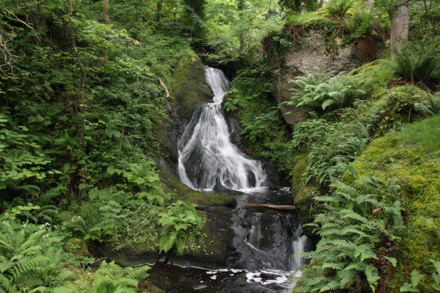
The wall turns a sharp right angle bend to the right (the junction of some fields). Continue to follow it. Then when it turns another sharp right angle bend to the right, find a point to cross the wall (there is no stile) into the field on the left. Follow the remains of a low wall down through the middle of the field, towards the stream. (There is a right of way down to the stream at the far right of this field, but this leads down a crag, and is a more risky approach.) Cross the stream, and start looking out for the remains of a stepped path running downstream on the left bank (when looking downstream). This can be followed with care to the bottom of the main Fairy Glen waterfalls - a 7 metre drop followed by a 4 metre drop. Cross the stream below the lower of these, onto a flat area that was once part of the commercial glen walk. Another waterfall lies below the flat area. (The right of way descends the crags above here.)
It would be possible to return the same way, over the field, then continue to follow the path running along the wall above until a path splits off to the left, which passes between some walls then drops down the valley. The route described below gains the same path eventually.
Follow the old path down the right side of the stream, until a sloping path leads up on the right. Ignore the glen path ahead, as it becomes too badly overgrown, and leads to the private garden. Ascend the sloping path on the right, continuing upwards through the undergrowth to reach the wall at the edge of the glen. Follow it to the left, staying at the edge of the wall. When the forest and wall finally end, and a more substantial path joins from the right, follow that path down ahead, dropping into the valley below the glen. Turn right on the road at the bottom, cross the bridge and turn right again to return to the start of the walk.
If you want to avoid crossing the private field (though still within the glen itself, which is probably also private), head up the lane away from the pub. Take the first left, over the bridge. Just before it enters private property, take a path to the left, which turns right then climbs up to the edge of some stone walled fields. Follow the right side of the walls, staying next to the wall - the path soon dies out. At one point, the wall turns very sharply right over a tiny stream bed, then soon afterwards turns extremely sharply left. Start descending here, but still heading along the valley (a bit more down than along at first), to locate the remains of a sloping path heading down into the valley - it only starts about two thirds of the way down, and can be difficult to locate from this direction. Be really careful to avoid the crags. At the bottom of the valley, head upstream along the old access path to the bottom of the waterfalls. Return the same way.
| Waterfall | Grid reference | GPS coordinates | Image |
|---|---|---|---|
| Fairy Glen | SH 74216 75818 | 53.264399°N, 3.887327°W | |
Whilst every care has been taken in the compilation of this description, neither the author nor his fellow walkers can accept responsibility for loss or injury arising from any errors, omissions or inaccuracies in this description. This description is intended as a guide only, and you should select a route to suit your own abilities, at your own discretion. Ability requirements are a guide only. Route maps are approximated. You follow this description at your own risk.