
Including Pwll Crochan, Pistyll Mawr, Cwm Nantmelyn Waterfall, Waterfall Cave Resurgence Waterfall, Ogof Clogwyn, Devil's Waterfall and Pwll Rhys.
From Cardiff, take the A470 to the A4060 junction just before Merthyr Tydfil. From Merthyr Tydfil, take the A4060 to its junction with the A465 at Dowlais Top. From Dowlais Top, take the A465 towards Abergavenny, to Brynmawr.
For the Brynmawr parking (which is part way along the upper section, not on the central loop of the walk), take the A465 exit slip road to Brynmawr. At the first roundabout, turn right to cross the Gateway road bridge. Shortly after the bridge, there is a small parking area on the right, frequented by dog walkers. SO 1975 1210. If that fails, take the second exit at the next roundabout, into Brynmawr. Take the first left, then the first left again, then the first left again, onto a tiny residential lane. Find somewhere to park. SO 1956 1210. Where the lane turns right, a path leads off ahead, which reaches the subway leading towards Pistyll Mawr, and stairs leading up towards the Gateway road bridge. Walking up the stairs onto the roundabout, crossing roads to reach the Gateway bridge road, and walking up to where the pavement has a road crossing before the bridge, reaches the start of the route. This is a useful access point to the walking route for residents of Brynmawr. If that also fails, there is more parking in Brynmawr itself.
For the Blackrock, Clydach South and Gellifelen parking, continue on the A465 past Brynmawr, and down the Clydach Gorge. At the bottom, take the exit slip road on the left, which is the first exit since the Brynmawr exit, signposted to Clydach and Llanelly Hill. Follow the slip road to a junction.
For the Blackrock parking, take the road on the left, and follow it back up the valley for 2 km, to a layby parking area with a bus stop on the left (if needed, there is some more space shortly afterwards, in a disused quarry's entrance on the right). SO 2149 1255. At the end of the layby is a footbridge crossing the A465, where the route starts.
For the Clydach South and Gellifelen parking, take the road ahead-right, then right again at the next junction, following signs for Clydach South and Llanelly Hill, passing under the A465 and heading back up the valley. It swings left and climbs to a junction. Turn right, and continue to a fork (where there is some parking space if needed at a football club and on a gravel area to the right). For Clydach South parking, take the right fork, continuing on the most obvious road ahead whenever it splits. Find somewhere convenient to park, preferably near the end of the road, where there is a small parking area. SO 2263 1279. For Gellifelen parking, take the left fork, and follow it uphill, crossing a dismantled railway. When the road hairpins around to the left, continue ahead, around a hairpin to the right, to a junction. Aim down to the right, take the first left, and drop down to a parking area beside some railway tunnels. SO 2149 1213.
The Clydach Gorge is a strange cross between wild gorge, and urban/industrial influence. There are many paths, but most are not really designed for countryside walks, and are better as utility footpaths for local residents. As a result, there are no convenient routes that take you easily from waterfall to waterfall; if this route seems a little disjointed as a result, that's because it is. The urban influence, however, means that almost all waterfalls have a convenient parking space nearby. As this is intended to be a walking guide, it will offer three parking options on the central loop, as well as a fourth parking option that is part way along the upper section. I would recommend the Clydach South (Danycoed) parking option, as it means the walk ends downhill, with the biggest uphill section being near the start, and offers interesting industrial remains to look at afterwards. The central loop of the walk, which contains most of the parking options, is 5.1 km. The optional upper section is 5.9 km, of which 1.3 km is the detour to Pistyll Mawr. The optional detour is 600 metres (800 if you are not also following the upper section). The optional lower loop is 3.8 km. The total walk, including all optional extensions, is 15.3 km. Most of that length is on paved cycle paths and minor roads, with about 1 km being on gravel paths, about 4 km being on trodden paths, and a 250 metre optional extension having no path. The distance gets covered relatively easily, but there are some steep sections, with very steep drops next to the path in a few places. It is a gorge, after all.
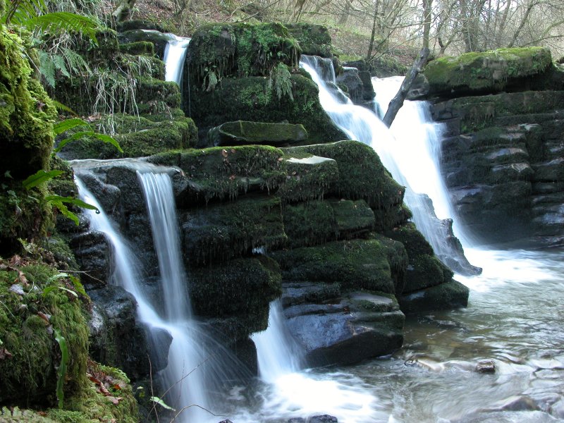
From Clydach South, take the footpath at the end of the road through the village (where you should be parked), and follow it up the valley. Officially, this part of the valley is called Coed Ffyddlwn (faithful trees), but it is also the bottom end of the part referred to as Cwm Pwca, Puck's Valley, where Shakespeare's A Missummer Night's Dream is based. As much of the valley was too steep for logging during the industrial revolution, it remains as one of the few ancient beechwoods to have survived in this area of Britain, and certainly one of its finest. Early on, the path splits and rejoins, but remains level until it crosses a bridge over a small waterfall, to reach a junction with a steep tramroad on the left. Continue ahead along the remains of a level tramroad to a set of powerful cascades, and then the lower Clydach waterfall (traditionally Pwll Crochan). For this last section, a ditch on the left of the path was once a leat which carried water from the waterfall to the Clydach Ironworks. Return to the steep tramroad, and follow it up until it reaches a road beside some lime kilns at Llanelly Quarry, and a dismantled railway line (Merthyr, Tredegar and Abergavenny Railway). Follow the road up onto the railway line, then take the railway line to the right. Follow it around a long curve (which has several small waterfalls in wet weather on the left side of the cutting) to an embankment and some tunnels, where a stream down to the left has a small cascade. The inlet valley to the right here is the heart of where the Clydach Gorge gets called Cwm Pwca, and the location of Shakespeare's Cave. Either go through the right tunnel (you will need a torch), or follow the path around to the right, staying level when it joins a road, to the other end of the tunnels. This is the Gellifelen parking area, where a small waterfall is up beside the tunnels, at the outflow of an adit.
From Gellifelen, there are two optional parts that may be of interest. The upper section takes in a few interesting waterfalls. The optional detour takes in three waterfalls. The upper section follows the right bank of the continuing dismantled railway line, heading away from the railway tunnels, soon passing the old station house on the right. The optional detour is to the right, just after passing the old station house, while the main upper section continues ahead. I recommend visiting the optional detour first.
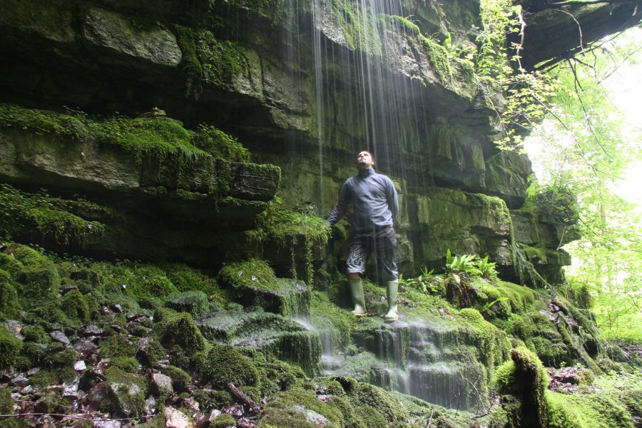
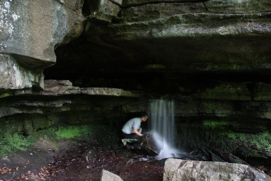
From the station house in Gellifelen, the optional detour is to take a path that heads down into the gorge, just past the old station house. This descends into the beechwoods, where it bends left then immediately right down some wooden steps. On the other side of the gorge is the Waterfall Cave resurgence waterfall - best seen in winter when there is less foliage. The path leads directly to the Ogof Clogwyn cave entrances, with a short waterfall dropping from its main entrance. A further cascading waterfall can be seen in the main river, just upstream. Return to the station house at Gellifelen.
Back at the station house in Gellifelen, the upper section continues along the dismantled railway line, away from the railway tunnels. After about 700 metres it reaches a junction at some houses. Continue ahead along the dismantled railway line. After 750 metres, the path passes over the Pistyll Mawr waterfall, shortly before passing under the Gateway road bridge, but it cannot be safely seen from here, or from the Gateway bridge, as it is guarded by huge crags. Shortly after passing under the Gateway road bridge, the path reaches the road, at the smaller Brynmawr parking area.
From the smaller Brynmawr parking area, there are two ways on, both of which involve crossing the road to the pavement on the far side. The detour to Pistyll Mawr, which can only be followed by experienced visitors, is to turn right towards Brynmawr, while the way on around the loop is to turn left towards the Gateway road bridge.
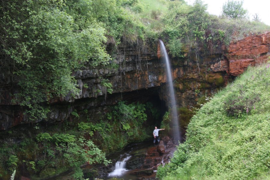
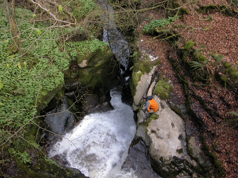
The detour to Pistyll Mawr follows the pavement down towards Brynmawr, to reach a roundabout. Cross the road to the left, to reach steps down to a junction. Ahead is the Brynmawr residential lane parking. To the right is a subway passing below the roundabout, signposted as a route to access the geological SSSI. Follow the subway, crossing the river in the middle of the roundabout, onto a path on the far side of the roundabout. This remains on the side of the A465, but ends at a locked gate leading out to the road. The only way downstream is to cross the wooden fence to the right (away from the road, not towards it), to access the river bank, but since there is no path, only experienced visitors should consider doing so. Keep the river to your right, and continue down the valley, close to the road. A culvert soon gets in the way, and the only way on is to follow the right side of the culvert, taking care not to slip in. Where the culvert gains a bank made from large boulders, the river falls down the waterfall at the pothole entrance to the artificial Coal Tar Cave, which is hidden through thick undergrowth to the right - be very careful not to fall down it yourself if you try to view it. A short distance downstream along the culvert, it turns right to reach Coal Tar Cave's resurgence adit, with an impressive 10 metre spout waterfall above it, traditionally known as Pistyll Mawr. (Before Coal Tar Cave was constructed during the Industrial Revolution, the entire river flowed over this waterfall.) Return to the pavement opposite the smaller Brynmawr parking area
Back at the pavement opposite the smaller Brynmawr parking area, follow the road uphill around a long curve and over the Gateway bridge over the valley, to reach a roundabout. The path you need to reach is down in the valley to the right, but 600 metres of extra walking gets added on by a very poor path layout (a common theme with every bridge over the A465, which all have lengthy loops pointing in the wrong direction instead of stepped paths). At the roundabout, the road you want is the second on the left, but to get there, you have to head to the right around the roundabout, crossing two roads, to reach the path on the left side of that road. Follow it around a very long curve next to a slip road, signposted to Abergavenny, descending to the side of the A465, after which the path heads into a forest. After 250 metres, the path crosses a stream, Cwm Nantmelyn, which has a small cascade just upstream of the footpath bridge. Take a small path beside the stream to a much bigger waterfall, then return back to the footpath bridge. Continue along the path to reach a junction, where to the left reaches a bridge crossing the A465. (There is a man-made waterfall 400 metres down the valley on the northern side of the road, but this cannot be seen from any paths). Cross the A465 using the bridge, and follow the path all the way up to the houses on the dismantled railway line. To the right here would lead back to the smaller Brynmawr parking area (a nice shorter walk for residents of Brynmawr), but this is not the main route. Turn left and return to Gellifelen.
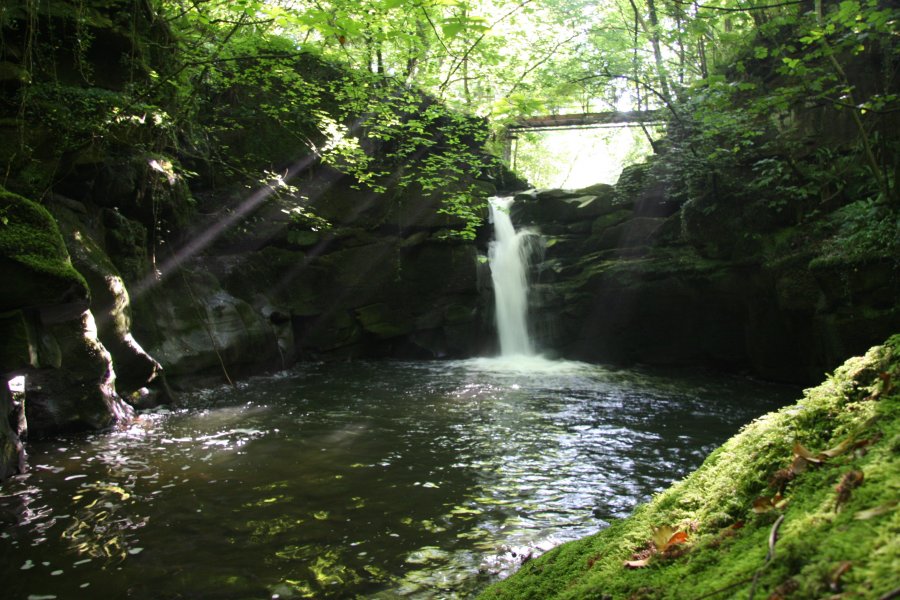
Back in Gellifelen (again), once you are finished with the upper section and optional detour, continue around the central loop. Head along the road away from the railway line and tunnels, taking the left branch when the road forks. After a short distance is a footpath on the left, just before a house. Follow it down a very steep route beside a stream gully, to the bottom of the gorge (to the left is a path to Pwll y Cwm, a major cave resurgence). The path crosses the Devil's Bridge, over the top of the Devil's Waterfall (traditionally Pwll Cwn), the largest and most powerful waterfall in the valley. The bridge is the best viewpoint - there is no safe way to access it from below. (The only way to get close is to use the cavers' route to reach Shakespeare's Cave, and wade up the river in knee-to-waist deep water, until it becomes too deep. This is far too serious for most walkers.) Cross the Devil's Bridge, and follow the path up to the A465. Follow the side of the A465 up the valley a short distance to a bridge over the road. Go over it to reach some houses and a layby, which is the Blackrock parking. The way on is to the right. (The Drum & Monkey pub was previously located near the houses, which was a good place to stop for refreshments. However, this was removed to allow the new road construction.)
From Blackrock, take the main village road, heading down the valley. Follow the road for a while, passing some lime kilns (Blackrock Limeworks) on the left. Shortly afterwards, take a path to the right (signposted incorrectly as Cwm Pwca), which descends a zig-zag to reach the path running along the valley just above the A465. Turn left. If you are unable to use the path, several other paths drop down to it from various points further along the road. Follow the path for about 550 metres, until it becomes a back lane. After just over 200 metres, take the first lane that heads down to the right, shortly before the first lane rejoins the Blackrock village road again. Almost immediately, take a path down to the left, which descends steps to a junction. Turn right over a bridge, then down a long zig-zag back into the Clydach South housing estate. (To the right is a footpath that leads behind the houses, back to the Clydach South parking area, which can be used if you do not plan on following the lower loop.)
Now back in Clydach South, the lower loop begins. Follow the road back out of the estate. If you just arrived over the bridge from Blackrock, this will be the obvious road ahead-right, then turn left at the T-junction. (To the right would be the road leading to the Clydach South parking.) Just before a football club and some playing fields on the left, take a path down to the left, to the Clydach Ironworks (1793) - the destination for the minerals prepared in the lime kilns, and transported down the tramroads. Cross the iron bridge (Smart's Bridge, 1824) over the river at the iron works, turn right onto a track, and follow it to a junction at the end of a road (or if you missed the iron bridge, exit the far end of the ironworks, and turn left on the road to reach the same place). Ahead-left is a sloping footpath up to a bridge crossing the A465, but the best way on is straight ahead onto a bridleway running along the riverbank. Part way along here is a waterfall in the river to the right, but it cannot be reached through the thick undergrowth, and is best seen from the bridge on the way back. The path passes under the A465 (keep left, and avoid the riverbank under the bridge). The path reaches the sliproad from the A465, and crosses it, passing through some trees to reach the Blackrock village road. Turn right and cross the Blackrock road as it bends right, taking a smaller road continuing ahead on the bend.
When the road forks, take the right branch. Just before it crosses the river, take a lane on the left, which passes through a private-looking driveway gate (signed as belonging to Forge House). After passing a couple of houses, take a narrow path tucked behind the houses on the right. After 250 metres, just after passing a bridge to the right, this reaches a powerful waterfall, Pwll Rhys (aka. Pwll-y-Rhechu/Rhychu), whose best viewpoint is a path on the right immediately after the waterfall. (Optionally at this point, a path up to the left reaches Maesygwartha, where the lane to the left can be used to create a variety of alternative loops back to Blackrock. However, there is no footway, and cars are allowed to drive past at 60 MPH, so this route guide does not use those lanes. Alternatively, the first path on the left in Maesygwartha drops back down to Forge House. The path continuing along the river beyond the waterfall leads to Gilwern, but this adds distance with no more waterfalls, so that route is not used here.)
Cross the bridge above the waterfall, and follow the path up to a cycle path. Turn right onto the cycle path, which used to be the main road. (At this point, a lane to the right can be followed back to Forge House if you dislike the cycle path). Follow the cycle path to the A465 slip road. (At this point, the road passing beneath the A465 to the left can be followed back to the Clydach Ironworks, but it is a dreary trudge with no reward.) Follow the slip road's pavement, which follows the road as it turns to the right, becoming the Blackrock village road. Cross the road back onto the path used to get here, but just ahead, at the junction with the path back over the sliproad to the left, continue ahead on the Blackrock road, towards Blackrock. After 350 metres, turn left onto a footbridge that crosses the A465. As the bridge turns right on the far side of the road (where it bounces quite uncomfortably in time with your steps), look down into the river a little upstream, to see the waterfall which could not be seen earlier. The view is best in winter. The path descends back to the junction near the Clydach Ironworks, completing the loop. Return through the Clydach Ironworks to the road at Clydach South. Turn right onto the road, and follow it through the housing esate, continuing on the most obvious road ahead whenever it splits, to arrive at the Clydach South parking area.
| Waterfall | Grid reference | GPS coordinates | Image |
|---|---|---|---|
| Pwll Crochan/Clydach Lower Waterfall | SO 22236 12661 | 51.807157°N, 3.129299°W | |
| Waterfall Cave Resurgence Waterfall | SO 21376 12429 | 51.804951°N, 3.141717°W | |
| Ogof Clogwyn | SO 21299 12388 | 51.804571°N, 3.142824°W | |
| Pistyll Mawr/Coal Tar Cave Resurgence Waterfall | SO 20068 12178 | 51.802509°N, 3.160625°W | |
| Cwm Nantmelyn Waterfall | SO 20194 12314 | 51.803749°N, 3.158829°W | |
| Devil's Waterfall/Pwll Cwn | SO 21551 12501 | 51.805623°N, 3.139195°W | |
| Pwll Rhys | SO 23753 14108 | 51.820374°N, 3.107619°W | |
Whilst every care has been taken in the compilation of this description, neither the author nor his fellow walkers can accept responsibility for loss or injury arising from any errors, omissions or inaccuracies in this description. This description is intended as a guide only, and you should select a route to suit your own abilities, at your own discretion. Ability requirements are a guide only. Route maps are approximated. You follow this description at your own risk.