Including the Cwm Gwrelych Waterfalls.
From Cardiff, take the A470 to the end of Merthyr Tydfil. From Merthyr Tydfil, take the A465 to the left towards Hirwaun, follow it over the hill, and down to the next roundabout. Take the second turnoff, remaining on the A465, to the next roundabout. Take the second turnoff onto the A465 dual carriageway. Take the first exit off the road after about 4.5 miles. Turn right at the traffic lights (the start of Glyn-neath), and continue as the road passes beneath the A470, and crosses the river into Pont Walby. Shortly after this, the road turns sharply left. Park on the roadside shortly before the corner. SN 8911 0658. (If needed, there is a lay-by 500 metres further up the road on the left.)
Two footpaths lead off to the right on the corner. The lower of these, directly opposite the Ynys y Nos lane, is the start of the walk. It begins as little more than a private driveway, but soon turns into a path and passes below a large viaduct. The river flows just below the path, and on its far bank, a tiny inlet stream contains the tallest of the area's waterfalls, but there is no path to them, and the waterfalls are not really worth the effort, tucked far up into the narrow inlet valley. (Above the far side of the river is an active opencast mine, whose land must not be entered.)
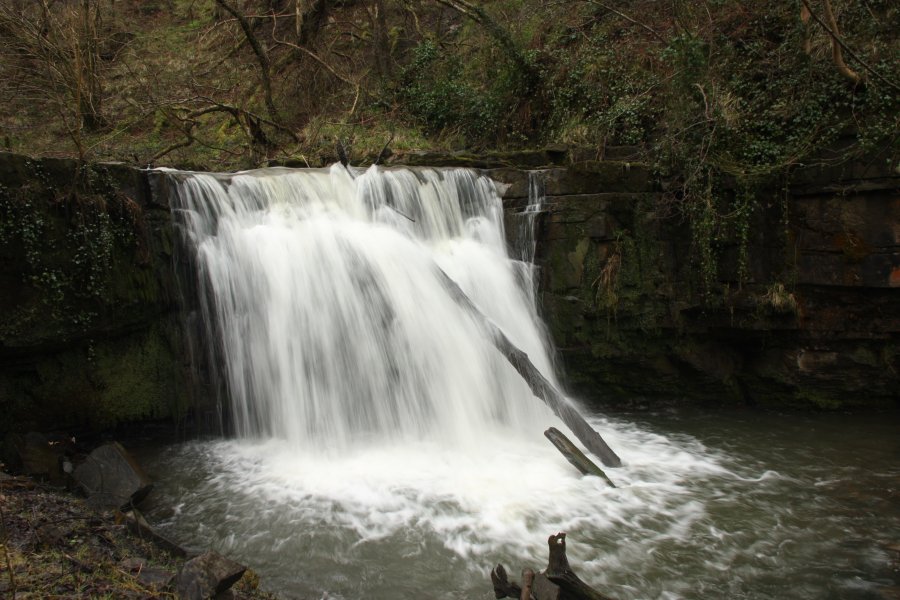
The path then swings away from the river and climbs up to a junction. Take the right fork for now, staying close to a fence. After 300 metres, the paths rejoin, and immediately split again. Again, stay to the right, near the fence. After another 300 metres, a small stream on the far bank appears to have some cascades, but in reality it has nothing to offer. 75 metres further on, the main waterfall appears in the river below to the right. This may be obscured by foliage in summer, but does not have any proper path to get a better view.
The path then curves away from the river, and reaches a junction with a mine adit ahead. Turn right and follow the path as it climbs up some steps towards a stream with some small waterfalls. Above the small waterfalls, the path reaches a major track (the remains of a tramroad) where there are some further small waterfalls. Turn right and follow the track over the stream. After 100 metres, an overgrown side track heads down to the right. Follow it as it heads down towards the river, then swing left instead to cross a bridge over a marshy patch. Some cascades can be seen on a stream on the far bank. As it heads upstream, the path passes over a set of very pretty cascades, and another cascade tucked into a meander. 450 metres after the bridge, some larger waterfalls appear on the right. The first has a path down to its viewpoint. Just after the second waterfall, the path reaches the track again at a junction.
From here, the track could be followed up the valley to the right for just over 1 km to reach the road at Rhigos. However, the track was blocked by a landslide during my visit in 2016, and there are no further waterfalls on it anyway. Therefore, it is not part of this walk route. Turn left on the track instead, and follow it back down the valley. Keep to the left when it splits, to reach the stream with the small waterfalls again. For a change of scenery, continue along the track this time. After 175 metres, continue past a track that doubles back on the left. After another 250 metres, another track leaves off on the left. As of 2013, there is an information board on the right side of the main track at this point. Take the track to the left, which descends to the other path near the bottom of the valley. To the right, this path forks immediately. Take the right fork, and follow it until the two branches rejoin. Continue ahead, descending back to the river, and then onwards to the start of the walk.
| Waterfall | Grid reference | GPS coordinates | Image |
|---|---|---|---|
| Cwm Gwrelych Waterfalls | SN 89811 05772 | 51.739785°N, 3.597237°W | |
Whilst every care has been taken in the compilation of this description, neither the author nor his fellow walkers can accept responsibility for loss or injury arising from any errors, omissions or inaccuracies in this description. This description is intended as a guide only, and you should select a route to suit your own abilities, at your own discretion. Ability requirements are a guide only. Route maps are approximated. You follow this description at your own risk.