Including Pistyll y Llyn and Pistyll Hengwm.
From Cardiff, take the A470 to the roundabout at Cemmaes Road. From Cemmaes Road, take the first turnoff (left) at the roundabout, onto the A489 to Machynlleth. Follow it to the A-road junction in Machynlleth centre. From Machynlleth, turn left onto the A487 towards Aberystwyth. After passing a roundabout, then a double mini-roundabout, then another normal roundabout, take the second left onto a small lane, signposted to Glaspwll. Follow it to the bitter end (just before this you may be able to get a distant view of Pistyll y Llyn from the road), where a small sign states that the road ahead is not to be used by cars, and there is some space to park on a forestry track on the left. SN 7568 9630.
After dry weather, the waterfalls can almost disappear, and being north-facing, are badly affected by sunlight. I suggest following this route after plenty of rain, on a day with complete cloud cover, and a high cloudbase. I have not had a chance to follow all of this route myself, so take a map, and prepare to use your own initiative.
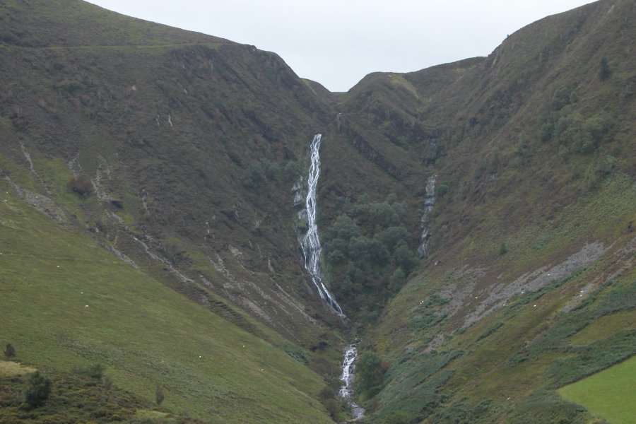
Follow the road around a tight bend to arrive at the farm. Pass between the farm buildings, then take a track ahead-left that passes above a series of barns, following signs for the waterfall. One field beyond the barns, take the left track when it splits, then when another track comes in from the left, turn right, picking up a level track that follows a fence line. Follow the fence line for a long way, taking care to avoid straying off the path into the very boggy grass that appears on the right. Pistyll y Llyn dominates the view at the end of the valley, dropping down a 91 metre horsetail (the second tallest of all single-drop waterfalls in Wales). The waterfall above and cascades some way below give a total descent of about 160 metres, making it equal tallest in total height of all waterfalls in Wales. However, the amount of stream involved in this height is quite significant, and Maesglase probably deserves the title more.
The path passes a tiny patch of forestry on the left then breaks out into the open, and heads towards a little tributary stream valley (which may be dry). A small clump of trees on the left surround a mine shaft. Follow the stream up to a junction of streams (either may be dry), ignoring the paths that head over to lower benches of the waterfall. At the junction of streams, follow the left bank of the right hand stream up to a little clump of trees, where there is another path. Follow it carefully to the right, as it climbs fairly steeply up the side of the valley, over an increasingly steep slope. Eventually it reaches the top of the waterfall and turns left to follow the stream.
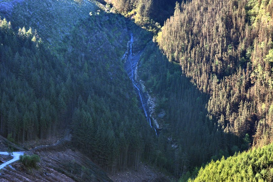
Here, it passes through a narrow parting on the edge of a forest, never straying more than about 75 metres from the stream, to reach a track. Take a short detour; follow the track to the right, then left at a junction to see Llyn Penrhaeadr, the lake that is the source of the waterfall's stream. Return to where you joined the track, and continue in the other direction (to the left when looking from the path). Follow the track as it winds its way to a junction with another track, and turn right. After passing the Hafodwnog buildings on the right, the track turns sharply left (with a side track on the right), then sharply right. On the right turn, take a poorer track to the left, a part of the Lôn Las Cymru cycling route. Follow it around the top of Creigiau Bwlch Hyddgen, keeping a look out to the right for Pistyll Hengwm, which can be seen at the end of the valley, in front of the Pumlumon mountains.
Eventually, the path crosses to the left side of the ridge, and drops down through forestry. Ignore a fire track that forks off to the right near the end of the forest, then when the track reaches the bottom of the forestry, follow the bottom edge of the forest to the right, ignoring a track joining from the left. Now running along the edge of fields with the forestry on the right side, when a track joins from the forestry on the right, leave the forestry edge and follow the track ahead-left that diagonally crosses through fields instead, towards a lower block of forestry. Remain with it as it descends all the way back to the start of the walk.
| Waterfall | Grid reference | GPS coordinates | Image |
|---|---|---|---|
| Pistyll y Llyn/Cwm Rhaiadr Falls | SN 75388 94248 | 52.531801°N, 3.838470°W | |
| Pistyll Hengwm | SN 77436 93216 | 52.522993°N, 3.807914°W | |
Whilst every care has been taken in the compilation of this description, neither the author nor his fellow walkers can accept responsibility for loss or injury arising from any errors, omissions or inaccuracies in this description. This description is intended as a guide only, and you should select a route to suit your own abilities, at your own discretion. Ability requirements are a guide only. Route maps are approximated. You follow this description at your own risk.