Including Rhaeadr Porth-llwyd.
From Cardiff, take the A470 to Llanrwst. From Llanrwst, turn left onto the B5106, signposted to Trefriw. Follow it to Dolgarrog. Continue past the surf site and pipeline, until just before the bridge over the river (where you can also check the water levels), where there is dedicated roadside space for parking. SH 7691 6770.
WARNING: The Afon Porth-llwyd is an extremely dangerous river. The water originates in two reservoirs, which cause the river to flash flood suddenly and without warning, with a flood pulse powerful enough to kill. Even in dry summer conditions, it is possible for the river to flash flood, if the water is not drawn to feed the turbines. The best advice I can give you is to stay a long way away from the river. The power station authorities have also made it very clear that they do not want anyone to risk their lives by walking along the river bed. Several signs point out the dangers, and advise the use of safe paths.
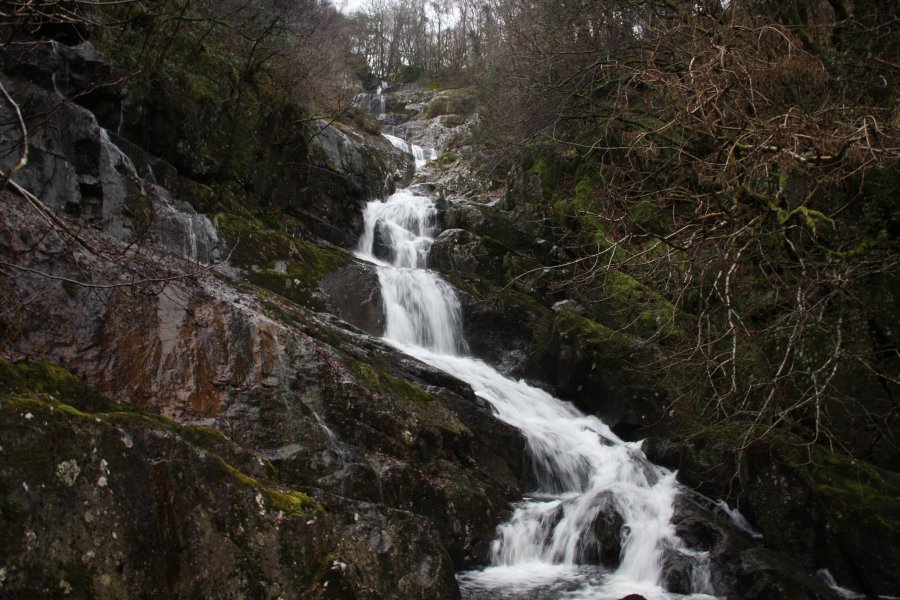
Under normal summer and winter conditions, the hydroelectric power station takes all of the water from the river, leaving it completely dry. Apart from the dribbles of water provided by small streams, the waterfall is normally dry. It is in autumn or winter that the river is most likely to carry water. This apparently happens most reliably in February, but can happen as early as October or November, needing about 3-4 days of heavy rain for the leats or reservoir to overflow. When the reservoir overflows, the amount of water can be intimidating, and most of the smaller waterfalls disappear under the white water.
This area has a fascinating history. On 2 November 1925, the poorly made Llyn Eigiau dam was overwhelmed and burst, after heavy rainfall. The floodwaters then burst the Coedty Reservoir below, and swept down the gorge, removing all of the boulders and trees from the walls and floor, and depositing them on top of the old Porth Llwyd village. The river's course around the village was completely changed. 10 adults and 6 children were killed, the majority of residents were saved by being at the local cinema and aluminium works.
Shortly before the river bridge, a memorial path leads into the forest behind an information sign. Follow the path through the flood-dumped boulders that cover the old Porth Llwyd village, heading towards the river. After heading upstream and passing a waterfall created by the flood (the view may be obscured by trees and boulders), the path swings left to a junction with a wooden balcony looking over some very large boulders - the site of the old waterfall. Take the right path to head back over to the river and continue upstream past another waterfall. Eventually the path dies just beyond a fence, with a faint glimpse of the last of the lower waterfalls (the gorge becomes extremely hard beyond here, and should not be followed). The line of older trees and boulders, about 14 metres up the walls, marks the level of the 1925 floodwaters. The clean washed line 2 metres up the walls marks the current flash flooding level.
Turn back downstream. Just after passing back through the fence, take a right fork to return to the junction with the viewpoint, then continue ahead-right to reach a lane. Follow it ahead. Turn left at its end to reach the main road through the village. On the left is an old village hall, built on the site of the old riverbed. The start of the walk is to the left, but the way on is to the right along the pavement of the main road.
Continue along the main road. On the left is the hydroelectric power station, a war memorial and the Surf Snowdonia centre. Just before the surf centre, the road crosses a bridge over the water pipeline supplying the power station. The pipe on the left (looking uphill) sits on what was previously an incredibly steep railway incline, used to lift engines and supplies up to the top of the escarpment. Walk up the right side of the pipes (heading away from the power station) to the next road. Then continue up the left side of the pipes, until a stile gives access to a footpath in the forest on the left, shortly before the pipelines get much steeper. Follow this path as it zigzags steeply upwards, known as The Zigzags. (There are also steps up the middle of the pipeline. In theory that is not a public right of way, although many people do use them to ascend the slope instead.) At the top of The Zigzags, the path again reaches the pipes, and turns left at the pipes to leave the forest at a large pipe junction. Ahead are an abandoned pipeline and the main pipeline. To the right is a building, with a shorter pipe coming in from its far side.
Expert walkers can now optionally approach the main waterfall from the southern bank. (Non-experts should skip this paragraph - the waterfall will be seen later anyway.) This requires experience with walking around crags and through undergrowth, and I would advise a GPS with 1:25'000 scale maps to aid navigation. Skirt the left side of the building, to reach the short pipe running out of its far side, and duck under the short pipe (or use the access lane to pass around it). Locate a wall running horizontally away from the pipe, heading back into the forest. Follow the upper (left) side of the wall, until it descends to a small stream and fence. Cross the stile to the junction of routes. To see the upper waterfall, follow the fence to the left from the junction of routes, to a stepping stone river crossing above the main waterfall, and below a little upper waterfall. To see Rhaeadr Porth-llwyd, follow the wall on the far side of the fence from the junction of routes, until it dies out. Try to continue very carefully along the same line through the trees and undergrowth, taking great care to avoid the steep slopes, clambering down to lower ledges if needed, to reach a ledge overlooking the top of Rhaeadr Porth-llwyd - most of it can be seen from here. My advice is not to ford the river, due to the dangers associated with flash flooding. From the junction of routes, it would be possible for expert visitors to descend into the gorge to the bottom of the waterfall, to see its lower steps, but I advise against this due to the risks of the river. This route guide does not cater to expert visitors who choose to ignore this advice - you're on your own. Return to the pipe junction.
From the pipe junction, head up along the left side of the abandoned pipeline, continuing in the same direction when it ends, to reach a leat carrying water to the reservoirs. Cross the leat using a footbridge, and turn right on the track on the other side. (The public right of way continues ahead and turns right later, but it then requires crossing the leat without a bridge. The track owners have allowed people to use their track, so that is the route this walking guide will take.) Follow the track back over the leat, then along the edge of the leat, until it ends at a public road. Decide if you would like to do the extended walk, which adds an extra 10 km of walking on gentle tracks and roads, to visit the two reservoirs that caused the disaster. If you would like the basic walk, turn right on the road, and follow it over the river until it bends to the left and a path leads off over a ladder stile on the right; skip the next paragraph.
For the extended walk, turn left at the road and follow the road over a stream (which supplies most of the water in the river when the reservoir is not overflowing), and then over the leat. Here, the road ends, and two tracks continue. Follow the right track along the side of the leat, passing above the rebuilt Coedty Reservoir. The overflow tipper gates are responsible for the current flash flooding behaviour. Continue for 4 km to reach the remains of the Llyn Eigiau dam's wall, which was intentionally breached at its outflow, after the disaster. The mountain views from this path are quite spectacular. Turn right on the track to cross the outflow, and right at the next junction, to return back down the valley. After 350 metres, a gap in the dam wall on the left is the accidental breach that caused the disaster, with the small valley being created by the floodwaters. A small path on the left of the valley allows access to the dam wall. Continue along the track to the parking area after another 1.3 km. Follow the road onwards for 3.3 km, passing a farm and farm tracks, to a junction with another road. Turn right and follow the road, taking the right fork early on. 120 metres after crossing a leat for the second time (where there is a track on the right), the road bends right and a path leads off over a ladder stile on the left.
From this point onwards, I have not followed this route, and therefore cannot be certain that the description is accurate. Visitors should ensure that they have an appropriate map, and be prepared to use their initiative. The grading of this part of the route is based on accounts from other people, and from various maps. However, it is possible that the grading is inaccurate. If you are concerned, please return down The Zigzags instead.
Cross the ladder stile into a field. The path runs close to the top of the river's trees, crossing a small stream, and continuing to the wall at the end of the field. It passes through the bottom of the next field, and into the bottom of the one after it. It then turns right to pass through a tiny triangular field, into the next field. It then passes through a gap in the wall some way above the valley's trees, into the next field that sits above the river valley. Up on the left is the ruin of a farm, but the path heads back over to the edge of the valley's trees again. At the end of the field, it again passes into the bottom of the next field, then begins to descend through the trees into the valley. Be careful here, as the drop down into the valley is quite significant.
A path joins from the right, which can be used to visit the upper waterfall at the stepping stone crossing. My advice is not to ford the river, due to the dangers associated with flash flooding. Continuing on the main path above the river, it skirts a large cliff, and at one point offers a view back towards the upper benches of Rhaeadr Porth-llwyd. Do not be tempted to get too close in order to get a better view - it is a very long way down to the bottom of the cliff. The path then swings away from the river, and reaches a path junction at some walls. Turn right to descend on an overgrown track, to a much more major track beside a house and barn. Turn right, and follow the track down a series of zigzags (passing two side tracks on the left), to reach the main road. Turn right to reach the start of the walk.
| Waterfall | Grid reference | GPS coordinates | Image |
|---|---|---|---|
| Rhaeadr Porth-llwyd | SH 76368 67588 | 53.190966°N, 3.851886°W | |
Whilst every care has been taken in the compilation of this description, neither the author nor his fellow walkers can accept responsibility for loss or injury arising from any errors, omissions or inaccuracies in this description. This description is intended as a guide only, and you should select a route to suit your own abilities, at your own discretion. Ability requirements are a guide only. Route maps are approximated. You follow this description at your own risk.