Including Ffrwd Fawr - Afon Twymyn and Nant Ddeiliog Falls.
From Cardiff, take the A470 to the Llangurig roundabout. From Llangurig, take the second turnoff (right) at the roundabout, continuing on the A470. After 5 miles it reaches the Llanidloes roundabout. Take the first turnoff (left) to enter Llanidloes on the B4518. At the little roundabout, take the third exit (right), then just after crossing the bridge, turn left to continue on the B4518 towards Staylittle. Ignore the two roads that lead off on the left immediately after passing through Staylittle. Shortly after the next cluster of houses, take a road to the left, signposted to Machynlleth. After 1.6 miles, in the middle of the desolate remains of the Dylife mining site, turn right on the village lane towards the Star Inn. Park in a gravel area immediately on the left. SN 8615 9403. The Star Inn lies a short distance further down the road.
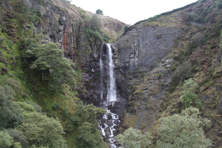
From the parking area, turn right onto the village lane, to reach the main road through Dylife. Turn left onto the main road, towards Staylittle, passing the impressive lead mining remains. After 1.3 km, arrive at a layby with an information sign, and a superb view over the very dramatic Dylife Gorge, containing the Afon Twymyn river. The gorge is one of the most impressive spectacles of the plateau, and well worth a look.
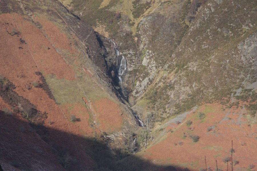
The main waterfall is tucked down to the left at the head of the gorge, but the view from the lay-by is annoyingly obscured. Continue along the road. At the first right bend, take the obvious track on the left. Ignore side tracks to the right and stay with the main track, near the hedges. Ffrwd Fawr, the most dramatic of the plateau's waterfalls, can be seen plunging 40 metres into the head of the gorge. At the third field on the left, you may want to head over the field to get the best view of the waterfalls below it, then return to the track and continue along it. The far side of the gorge swings away, and on the far side of the wider section, the Nant Ddeiliog Falls can be seen falling out of a small side valley.
The basic walk ends here, since all of the waterfalls have been seen. However, if you would like to extend it, there are some opportunities, but I have not followed any. My suggestion is the following route, which you will need to have a map for. Continue along the track, which soon fords a (potentially dry) stream, and runs along the top of the scarp, next to a large field. (An alternative path branches off to the left shortly after the stream, which drops steeply down to the Pennant-isaf farm. This path misses out on some of the views, and requires more walking on-road.) Continue along the scarp-top until the track joins a much more substantial track which is turning a hairpin bend. Continue ahead-left on the substantial track.
Stay with the track as it takes its position on the middle of a hill ridge. When it turns hard left to leave the ridgetop (it drops down to the Pennant-isaf farm), continue ahead on a grassy track that remains on the ridgetop. Note that this section of the route is not shown as a public right of way on the map, but appears to now be a concessionary footpath. For the first field on the left, the grassy track has a fence on both sides. For the second field, it has no fence on the left side, and instead it runs along the edge of the field itself. For the third field, there is a fence on the left side again. At the start of the fourth field on the left, take a track heading diagonally over the field to the left, which becomes much more substantial as it descends and zigzags down to a country lane close to a bridge over the Afon Twymyn river.
Continue ahead on the country lane to cross the river. At the little Cilcwm village, two farm tracks head up to the left. Take the left track towards the Cilcwm-fawr farm. At this point, the right of way passes through the farm and along the slope behind it. However, a concessionary path provides a much better route. Just as the track turns left at the start of the farm, follow the footpath signs through an enclosure on the right, curving up into the field above the farm. Follow the path along the bottom edge of the field, passing the farm buildings, until a gate offers a way onto open access land, near the bank of a tributary stream - take care, as erosion has historically caused parts of the bank to slip into the stream, and the footpath may have been diverted as a result.
Follow the path down to the bank of the river. Head upstream along the right bank of the river, crossing the tributary stream. At the next tributary stream, a new, long field starts on the river bank. Cross the tributary stream upstream of a meander (there may be a waterfall hidden in the trees to the right, but I have not checked this), and continue beside the right side of the field, just below the trees that line the side of the valley. At the point where a track descends from the forest on the right, enter the field through a gateway on the left. Head over to the field's upstream end. In the middle of the field's upstream end, a stile crosses the fence, and the path continues upstream. After 100 metres, the official way on is to ford the river, and continue upstream on a track that runs on the left bank. (If the river level is too high, the right bank appears to be a concessionary footpath, which can be followed up to the alternative lifestyle encampment.)
Now on the left bank of the river, continue upstream along the track, until the river turns a couple of left bends at its junction with the Nant Ddeiliog stream, and the track ends at the river's edge (a smaller path continues upstream). According to the map, there is a footbridge here, and the right of way crosses it, but the bridge appears to have been moved a little further upstream. Cross the river to a field containing an alternative lifestyle encampment. Now back on the river's right bank, turn right and head back downstream to the junction of the Nant Ddeiliog and the Afon Twymyn. Head a short distance upstream along the Nant Ddeiliog, where there is a track belonging to the camp. Look for signs pointing into the trees to the left, towards the ongoing path, just before the track crosses the Nant Ddeiliog.
The path passes through a line of trees separating the field from an upper field, and then skirts the right edge of the upper field staying just inside the trees. It swings left as it climbs towards the top of the field and breaks out into the uncultivated land above, where it is named the Postman Path (Llwbwr y Ceirw in Welsh, meaning the Stag Path). After heading along the top of the field for a while, it starts some zigzags to climb the steep side of the gorge, above a tributary of the Nant Ddeiliog, which splits into two near the top. At the top, above the right branch of the tributary (ignoring a path to the left near the top), it crosses a fence into the left-hand of two fields, and follows the fence between the fields. At the far side, it swings right beside a dry gully, towards a small stream valley. Just before the stream, it turns left again to drop down to a major track.
Turn right on the track to cross the stream, after which it swings left to climb back up to some fields. When the track dies out, continue along the left edge of the field, to a house and track in the far corner. Follow the track past the house, which becomes the main village lane. A private driveway forks off to the left then another forks off on the right. Continue on the main village lane to pass the Star Inn on the right. A short distance further on is the parking area and the end of the walk.
Note that the Star Inn is a bed and breakfast, which also serves lunches and dinners, by appointment only. If you would like to start or end your walk with some refreshments there, please see the Star Inn's website to make arrangements.
| Waterfall | Grid reference | GPS coordinates | Image |
|---|---|---|---|
| Ffrwd Fawr | SN 87192 93977 | 52.531940°N, 3.664446°W | |
| Nant Ddeiliog Falls | SN 86724 95298 | 52.543714°N, 3.671794°W | |
Whilst every care has been taken in the compilation of this description, neither the author nor his fellow walkers can accept responsibility for loss or injury arising from any errors, omissions or inaccuracies in this description. This description is intended as a guide only, and you should select a route to suit your own abilities, at your own discretion. Ability requirements are a guide only. Route maps are approximated. You follow this description at your own risk.