Including Craig y Ffrwd and Craig y Llo.
From Cardiff, take the A470 to the Llangurig roundabout. Select your route below:
For the main walk, from Llangurig, take the second turnoff (right) at the roundabout, continuing on the A470. After 4 miles turn left on the B4518 (signposted to Tylwch), and follow it into the Llanidloes town centre. From Llanidloes, turn left at the 400 year old Market Hall, towards the Hafren Forest (turn left after crossing the bridge). After 3 miles, it forks, with no road markings to say which is the main road, but with a sign pointing to Hafren on the right. Take the road ahead. It swings left, crosses a bridge, then swings right. Take the next road on the right. Eventually, it climbs up to a farm at the edge of some forestry, where there is some space to park just inside the forest. SN 8795 8509.
For just Craig y Llo, from Llangurig, take the first turnoff (left) at the roundabout, onto the A44 towards Aberystwyth. After 11 miles, take an unmarked lane on the right - the first turning to the right since a lay-by on the right with its own phone box, and the third proper road on the right (ignoring driveways) since the end of Llangurig. Follow the narrow lane over a cattle grid and through a gate. After passing a second cattle grid, the road enters a tiny woodland as it turns a tight corner over a stream. Then it breaks back out into the open for a little while before entering a much larger woodland in the newly developing valley on the right. There is some space to park on the right as soon as the road enters the woodland, and some more on the left 300 metres later. If possible use the lower space, as the upper one is the only passing space for several hundred metres in both directions, and sits above a very steep drop. SN 8998 8395.
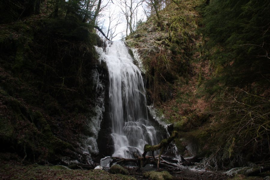
Head back down the road past the farm, and go through the first gate on the right. Follow the fence on the left of the field until you can see the fence running along the edge of the forest ahead, then swing right towards a gate leading into the forest (about 75 metres from the field's left fence). Go through the gate and down a sloping track to reach the stream. Head upstream on the left bank, over various fallen trees, to reach a cascade then the Craig y Ffrwd waterfall.
I have not followed the off-road part of the route from here, but the details given here should be enough for you to follow it; return to where the track reached the stream, and continue along the track in the other direction (which heads up the right bank pointing significantly downstream). It arrives in a field near a small building. Continue past the small building towards the end of the field, and cross a stream into another field on the right. Head diagonally up to the right, keeping trees on both sides, to reach a track (it is perhaps best accessed using the field's gateway, which enters the track on its first corner, a little to the right of where the right of way officially reaches it). Turn right and follow the track uphill. The official right of way cuts and extends various corners, but the path does not seem to exist any more, and the track is the best compromise.
The track turns left (at the field's gateway), then later right, then left again (where another track joins ahead). Ignore the side track on the right on the last corner, and continue with the main track, which soon reaches the middle of the ridge, and heads down it. The track passes two clumps of trees that touch the edge of the track on the left. The next field on the right starts, and 75 metres further along, shortly after a narrow line of trees ends on the right, head across the field on the right side of the track, to reach the Hafod-Wen farm. Follow their track down to the road (there is an alternative right of way here, but like many in the area, it does not exist as a path, and the end is blocked). Turn left on the road and follow the road down to a woodland with a steep slope on the right side of the road.
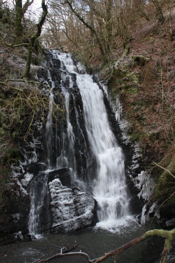
The next waterfall lies almost directly under the parking space at the start of the woodland, but is best approached from a little downstream, to avoid walking above the crag. Walk around 200 metres further down the lane, then find somewhere convenient to descend the steep slope down to the stream. Head upstream to the Craig y Llo waterfall. (A vague path climbs over the smaller crag on the right, but only leads up to the parking space.) When you have seen what you want to see, return the same way (or if you want a change, head down the road to a junction, turn left and follow the road all the way back to the start of the walk).
The waterfall lies almost directly under the first parking space, but is best approached from a little downstream, to avoid walking above the crag. Walk around 100 metres back up the lane from the lower parking space (200 metres down from the upper parking space), then find somewhere convenient to descend the steep slope down to the stream. Head upstream to the Craig y Llo waterfall. (A vague path climbs over the smaller crag on the right, but only leads up to the upper parking space.)
| Waterfall | Grid reference | GPS coordinates | Image |
|---|---|---|---|
| Craig y Ffrwd | SN 87908 84926 | 52.450754°N, 3.650846°W | |
| Craig y Llo | SN 89760 83794 | 52.440959°N, 3.623232°W | |
Whilst every care has been taken in the compilation of this description, neither the author nor his fellow walkers can accept responsibility for loss or injury arising from any errors, omissions or inaccuracies in this description. This description is intended as a guide only, and you should select a route to suit your own abilities, at your own discretion. Ability requirements are a guide only. Route maps are approximated. You follow this description at your own risk.