
Including Conwy Falls, Machno Falls, Pandy Falls and the Fairy Glen gorge.
From Cardiff, take the A470 to its junction with the A5 at Betws-y-Coed. From Betws-y-Coed, turn right onto the A5, signposted towards Llangollen. After 1.5 miles, turn right onto the B4406, signposted to Penmachno. Immediately turn right into the Conwy Falls Cafe parking area. SH 8107 5352.
(Note that this walk includes the Fairy Glen attraction near Betws-y-Coed, not the ex-attraction near Conwy.)
Conwy Falls and Fairy Glen are run as commercial ventures, and a fee is charged for entry in both cases. If you were parking at the Fairy Glen parking area, a separate fee would also be charged for parking (and they do not like visitors to park for long enough to do the whole walk). Note that most of this route takes place on or beside roads, as the area is almost devoid of convenient footpaths for this purpose. The route has two short sections on major A-roads, which cannot be avoided - it is of course possible to drive between sites instead.
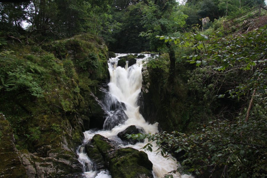
To begin with, go through the Conwy Falls site entrance on the right of the cafe (or you can leave this to the end and have refreshments before visiting the site - there is no official agreement that they will offer reduced prices to customers who pay for a meal ... but you never know, right?). There are a number of routes through their site, and you can choose what works best for you. The favourite is the circular route starting on the far left of the site, which follows the gorge down to the Conwy Falls, then returns through the woodland. If you take one of the other routes, you may still want to head up beside the gorge.
Once you have seen what you want, return to the parking area, and head down the B4406 away from the A5. After 800 metres, take the first right, into a quieter lane at a tiny village. Just before crossing the river, the Penmachno Woollen Mill is on your left. From the bridge over the river, look left to see the Pandy Falls upstream beside the woollen mill - perhaps best seen in winter when the leaves do not block the view. Look downstream to see the old Roman Bridge over the river.
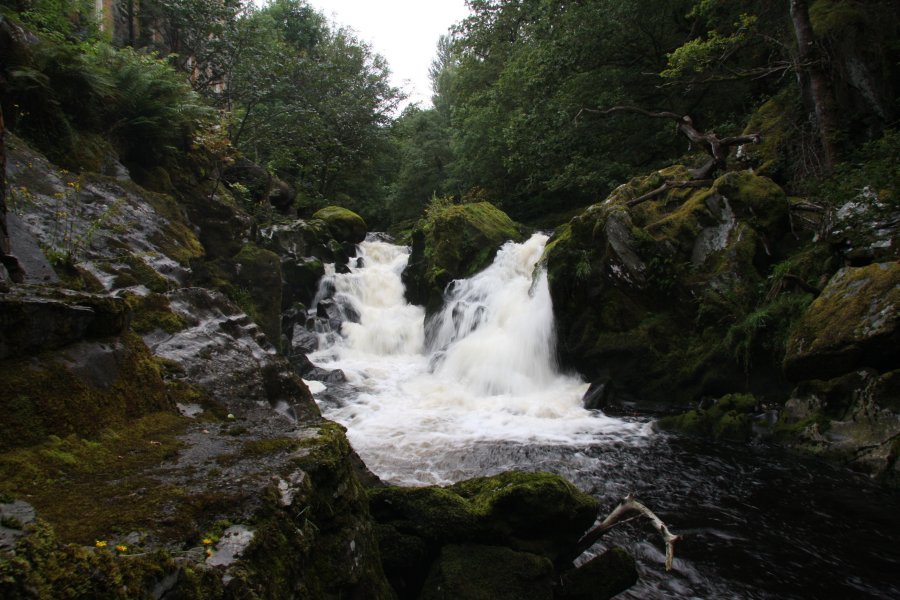
Continue along the lane until you reach a cluster of houses. The last house on the left was once the Pandy Mill, and directly opposite it is their private garden, with the Machno Falls below it. At the far end of their garden, a path leads down to a public viewing platform for the waterfall (unprotected, take care). The waterfall has had a fish pass added on its right side, so very little water actually falls down the waterfall in most water conditions.
Continue along the lane for 1 km, where there is a lay-by on the left, and the lane ahead gains a wall and fence on the right. Opposite the lay-by is an unofficial path leading down to a ledge over the upper end of the Fairy Glen gorge. Take care. Shortly before the ledge, a side path leads upstream (to the right as you approach the gorge), to the cascades at the gorge's head. Return to the lane.
Continue along the lane for 500 metres, keeping to the right when it splits into several branches after 200 metres, then ahead at the next junction, to reach the main A470 road. Cross the road, turn right and take the footpath that follows the roadside. After 500 metres, the path gives up at a junction. Carefully walk along the A470 to cross a bridge, then turn right onto the track on the other side, signposted to the Fairy Glen. Follow the track to the entrance to the Fairy Glen site.
Head through the archway on the right (where the fee is collected), and follow the path to a junction. Turn left to reach a junction at the edge of the gorge. Firstly head left to reach stone steps down into the main gorge viewpoint. Then return to the gorge-top path, and follow it in the other direction, to the mouth of the gorge. Beyond here, the path leads back up to the entrance to the site. Turn right on the track, and continue along it. It eventually turns into a path, which continues through a woodland to reach the side of the A5. Follow the side of the A5 for 200 metres to reach the B4406 and the start of the walk.
| Waterfall | Grid reference | GPS coordinates | Image |
|---|---|---|---|
| Conwy Falls/Rhaeadr y Graig Lwyd | SH 80912 53477 | 53.065221°N, 3.778667°W | |
| Machno Falls | SH 80836 53226 | 53.062949°N, 3.779708°W | |
| Pandy Falls/Penmachno Falls | SH 80629 52865 | 53.059659°N, 3.782661°W | |
Whilst every care has been taken in the compilation of this description, neither the author nor his fellow walkers can accept responsibility for loss or injury arising from any errors, omissions or inaccuracies in this description. This description is intended as a guide only, and you should select a route to suit your own abilities, at your own discretion. Ability requirements are a guide only. Route maps are approximated. You follow this description at your own risk.