Including Garwnant Waterfall and some smaller unnamed waterfalls.
From Cardiff, take the A470 past Merthyr Tydfil towards Brecon. After passing the tiny village of Llwyn-on and its reservoir, take a small lane on the left, signposted to the Garwnant Centre. After crossing a bridge, ignore a forestry lane on the right, then immediately take a fork to the right, signposted again for the Garwnant Centre. Follow the lane up to the parking area, taking note of the last track (with a barrier) on the left just before the main parking area begins at the Garwnant Visitor Centre. SO 0027 1310.
The main waterfalls lie directly beside the parking area, and if you do not plan on following the main walk, they can be viewed even by disabled visitors. Return down the parking area access lane, and take the first track to the right (the one with the barrier that you passed on the way up). Take a path that branches off on the left, which passes directly over the waterfalls. If you plan to follow the main walk, skip this paragraph, as it spoils the surprise at the end.
The main walk begins by following the exit lane out of the parking area - this is at the opposite end of the site from the entry lane, and is clearly marked on the road and on signs. 200 metres after the parking area, the road turns a hairpin bend to the right, and a track with a barrier continues ahead. Take the track ahead, and follow it past a farm on the left. It then bends a long way to the right then back to the left, after which it crosses a stream (with a rather poor little cascade on the right) to reach a path junction. Take the path heading downhill to the right. This reaches the edge of the forestry land at a gateway into some fields (note that the trees may occasionally be felled, so the edge of the forestry land may not be so obvious).
At the fields, the path splits. (Note that the Ordnance Survey maps of this area do not show the path in the correct location.) Turn left and follow the top edge of the fields, at the edge of the forestry land. At the end of the field, cross a stile marked with Taff Trail signs into the next section of path leading into the next small field (with the remains of a ruined building on the right). Continue in the same direction to the end of the field, then cross a stile, a bridge over a stream, and another stile into the next field. Immediately cross a stile to the left to return to the forestry land. Continue in the same direction as before, keeping the forestry edge fence on your right. This section may be overgrown in some places, but the route should remain obvious. After 650 metres the path passes above the Nant Ddu Lodge (hotel) and passes through the remains of a gateway where it finally leaves the fence. 250 metres further on, a water treatment works can be seen below to the right, and the path becomes a more substantial track. 400 metres later, it reaches the Cantref Reservoir dam, where Fan Fawr, Craig Cerrig-gleisiad, y Gyrn and the Cefn Crew ridge dominate the view over the reservoir.
Continue along the left side of the reservoir, taking the left branch when it splits, until the path passes through a gate and reaches the Nant y Geugarn stream, where it turns sharply left. The stream has several waterfalls. The first may be viewed from the bank of the stream at the sharp bend in the path - note that there is no formal viewpoint, and the drop to the stream is quite abrupt, so take care. Follow the path uphill past more small waterfalls. The path bends left and soon ends at a forestry track. Turn left and follow the track for 2.5 km, passing a few side tracks, until it ends at a junction with another track, where a smaller path joins from the left. Depending on tree felling state, there can be some good views of the mountains and the Taf Fawr valley during this section. Ignore the tracks and continue ahead instead, onto a path.
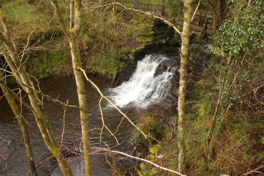
The path zigzags before crossing a bridge over the main Garwnant Fawr stream, where there is a small twin-spout waterfall upstream. The path then crosses the Garwnant Fach stream as it heads downstream. When the path crosses the next bridge to return over the Garwnant Fawr stream, continue ahead instead, on a less formal path running downstrean on the right bank. This soon passes a weir, and reaches a bridge at the head of the main Garwnant Waterfall. Cross the bridge and ascend back up to the main path. Turn right and follow the path over a few more little waterfalls in the stream, until the path joins a track (there is a shortcut to the parking area on the left). Continue ahead with the track to reach a junction of lanes just past a barrier. Turn left to return to the parking area, and the start of the walk.
| Waterfall | Grid reference | GPS coordinates | Image |
|---|---|---|---|
| Garwnant Waterfall | SO 00185 13064 | 51.807273°N, 3.449146°W | |
Whilst every care has been taken in the compilation of this description, neither the author nor his fellow walkers can accept responsibility for loss or injury arising from any errors, omissions or inaccuracies in this description. This description is intended as a guide only, and you should select a route to suit your own abilities, at your own discretion. Ability requirements are a guide only. Route maps are approximated. You follow this description at your own risk.