Including the numerous Tareni Gleision waterfalls.
From Cardiff, take the M4 to junction 45, and take the A4067 to the right towards Pontardawe. For the lower set of waterfalls, follow the A4067 to Godre'r Graig (before Ystayfera), currently after the fifth roundabout since the M4 junction. There is a dedicated parking area on the right, directly opposite the Godre'r Graig access road (the access road can be identified by the "Exhaust & Tyre" servicing garage at its start). SN 7528 0655. For the upper set of waterfalls, follow the A4067 to the Pontardawe roundabout, currently after the fifth roundabout since the M4 junction, and take the second exit onto the A474. At the next roundabout, take the fourth exit (hard right) towards Neath. Continue that way, climbing up a hill to Gellinudd. Just before the second bend in Gellinudd, take Cwmnantllwyd Road which forks off ahead-left, and soon becomes a narrow lane. At the end of the lane, turn left onto Church Lane. Follow it for a long way to reach a parking area just before the Tareni Gleision farm. SN 7547 0603.
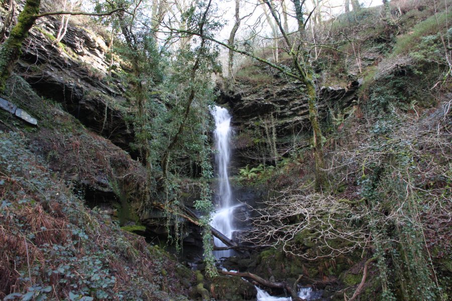
For the lower waterfalls, take the track from the end of the parking area, and cross the bridge. Turn left at the junction of paths. Follow the path to the left past a couple of streams for about 700 metres, to where a sloping path doubles back on the right. Walk up that path to reach the previous stream. Some small waterfalls are hidden in the gorge below (beginners should not attempt to see them, as they are guarded by small cliffs), but upstream is the area's crowning glory; the main Tareni Gleision waterfall. Beginners should turn back at this point, as the continuing paths have been lost to the undergrowth.
Very experienced (expert) walkers may consider ascending the slope on the left, following a fence up, to reach the next waterfall, which has a mine entrance behind its veil. The same approach may be used to reach the next one. Above that are two more, but they are tucked into a gully at the top of the tall crags, and are very risky to reach. I advise against attempting to reach them, and against attempting to reach the upper set of waterfalls from here (though it may be possible to ascend the slope on the right beyond the crags). Use the upper path instead.
For the upper waterfalls, start at the parking area near the Tareni Gleision farm. The path at the end of the parking area should in theory connect to the lower path, but its lower end has become too overgrown to be of use. Instead, follow the lane up to the farm (currently a kennels), and follow the track skirting the right side of the farm, which slowly curves left. Ignore various side tracks and continue to follow the main one in the same direction. Eventually it enters a woodland, and part way through it, it crosses a stream. The upper waterfalls are on this stream, with one being visible on the right (two above it have no proper path to them). Two further waterfalls lie a short way downstream, but are more tricky to reach safely, as the they are in awkward locations, and the cliffs around them have started to collapse. Beyond them is a fence, and on the other side of it is the top of the lower set of waterfalls. Do not attempt to cross the fence below the second waterfall, which protects against the tall crags of the lower waterfalls.
If desired, the path can be followed beyond the stream to reach views over the Black Mountain range. In theory, several tracks could be used to descend to the cycle path and connect to the lower section, but these are likely to be overgrown and hard to find.
Note that the stream has a very small catchment, and probably needs a few days of significant rainfall to become interesting.
| Waterfall | Grid reference | GPS coordinates | Image |
|---|---|---|---|
| Tareni Gleision | SN 75804 06573 | 51.744052°N, 3.800280°W | |
Whilst every care has been taken in the compilation of this description, neither the author nor his fellow walkers can accept responsibility for loss or injury arising from any errors, omissions or inaccuracies in this description. This description is intended as a guide only, and you should select a route to suit your own abilities, at your own discretion. Ability requirements are a guide only. Route maps are approximated. You follow this description at your own risk.