


Including Twyn y Crug Waterfall, Corrwg Fechan Falls, Corrwg Falls, Nant Meliorath Falls, Nant Cwm-cas Falls and Nant yr Allor Waterfall.
From Cardiff, take the M4 to junction 36. From there, follow the A4063 to Maesteg. Here it does a poorly signed right turn, followed by a left turn. Continue along the A4063 to Cymer. At Cymer, cross the A4107, and continue ahead onto Maesteg Road (watch out for the hairpin bends). At Glyncorrwg, the road turns sharply left, then drops to cross the river. Take the second right onto Heol-y-Deryn, almost immediately after the bridge. The road crosses a stream then passes a track and grassy area on the left. Immediately after that is another lane on the left which is the start of the walk. Park on the roadside on Heol-y-Deryn. SS 8749 9934.
WARNING: This route is subject to disruption, as a wind farm is being constructed in the area, as of 2016. Several tracks may be modified during the construction, and various tracks may be temporarily closed. Visitors may need to re-invent certain parts of the route.
Do not underestimate the difficulty of this walk. Most waterfalls are in awkward locations, hidden in little gorges beyond awkward forestry land. The walk is also about 15 km long, and quite tiring.
Start up the lane on the side of Heol-y-Deryn and immediately turn right. Follow it to the start of the main forestry track, and continue along that. Just before a gate that blocks the main track, another track doubles back on the left towards a house at Llwyn-y-ffynnon. Part way along this, a stream draining Twyn y Crug comes in from the right, which has the first waterfall a short way up it. There is no path up the stream.
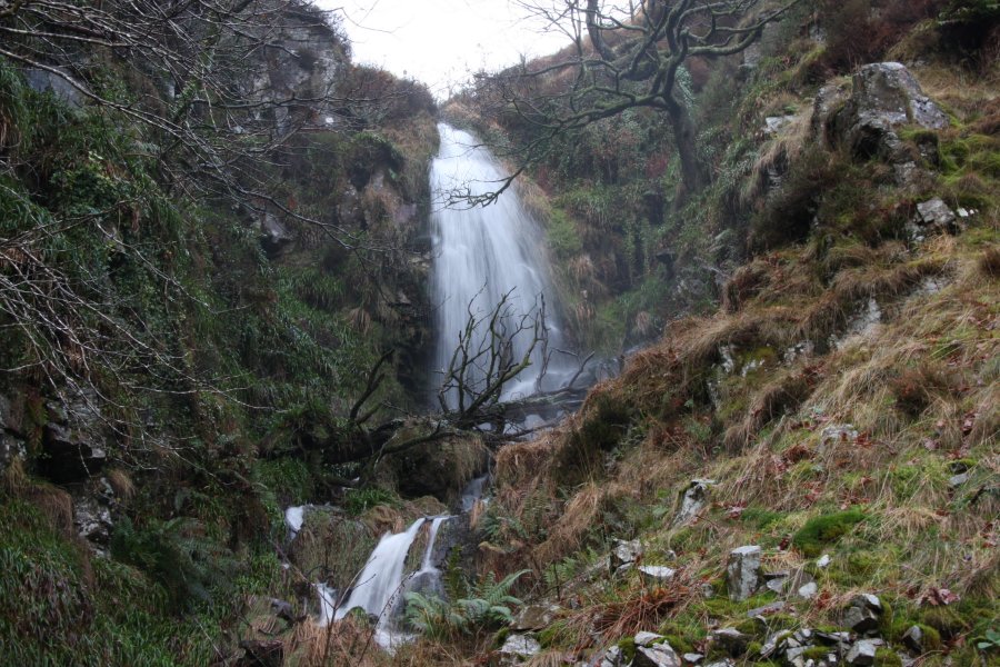
Return to the main track, and go through the gate. Stay with the track as it passes the obvious Mynydd Corrwg Fechan hill on the right, curves left for 1.5 km, then performs a series of tighter bends to pass the head of the Afon Corrwg Fechan. As it turns the bends, continue ahead-right at a track junction then take a right fork, to remain near the stream valley. Just as the track finishes its bends (and having now crossed the Afon Corrwg Fechan), so that it is facing Mynydd Corrwg Fechan again, the Corrwg Fechan Falls are down in the gully on the right. A few cascades are below it, and some streams on the other side of the river have their own waterfalls. Take great care if crossing the river to see them.
Further downstream in the little gorge are some more waterfalls, none of which are really worth the effort, but expert visitors may choose to follow the gorge edge downstream to see them. Take great care, and head back up to the track after finding the last waterfall, which has a fence leading all the way up to the track, marking the edge of the old forestry plantation. Other visitors should simply follow the track to reach the same point.
Back on the main track, continue into the Cwm Corrwg valley, where the slope below the track starts to descend more steeply. (The track skirts the head of this valley too, but that misses out on most of the good stuff.) Recent tree felling operations have changed this area, and landmarks may be hard to locate. Several small streams cross the track, some of which are significant enough for the track to dip sideways temporarily to cross them. 250 metres after the second time this happenes (Nant Gau is the third), 150 metres after another track has joined from the left, the next major waterfall, Corrwg Falls, is down in the valley to the right. Take care when descending to it as there are cliffs if you drop down too close to the side streams. The waterfall is perhaps the best in the area, but had a large amount of fallen trees blocking it during my visit.
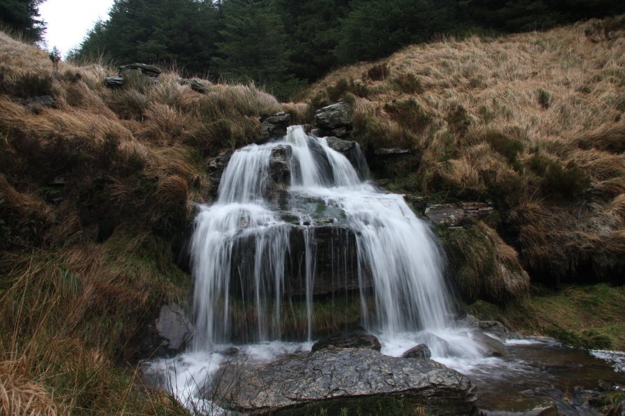
Stay in the valley and head downstream, find somewhere to cross the river, and continue downstream. Soon on the left is Nant-Pigws-y-waun, followed by the remains of the Old Blaencorrwg house, followed by a small waterfall on the Afon Corrwg. Head back upstream then turn right to follow the Nant-Pigws-y-waun stream, which has several pretty waterfalls, to reach the track returning down the valley. Turn right and follow the track as it dips firstly into the Nant Melyn valley (ignore side tracks) then rounds the next buttress. Part way around the buttress, it forks - take the left branch to continue rounding the buttress. On the far side of the buttress, the track climbs up to a junction with another track that is turning a hairpin bend, where a grassy track joins from the left. Turn right, and follow the track past some zigzags for just under 1 km, passing a wind turbine on the right part way along, until it crosses the Nant Cwm-cas. Follow the stream down to a path and fence. Just below the fence are the Nant Cwm-cas Falls. Follow the path to the right to reach the Nant Meliorath stream, which has the Nant Meliorath Falls below the path. Head down the stream, crossing a fence into open landscape, until a tramway can be seen dropping steeply down on the left.
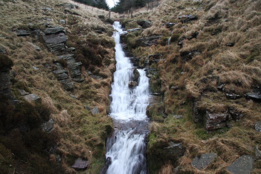
Follow the tramway down, crossing fences at the bottom to reach a track on the other side. Follow the track to the left, staying on the left bank of the main river. The track soon passes the cascading Nant yr Allor Waterfall on the left before reaching the village and becoming a road. At the end of the road, turn right then left, to arrive at the river crossing that you drove over just before the start of the walk. Cross the bridge and Heol-y-Deryn is on the right. If you still want more, do not turn right into Heol-y-Deryn, and instead continue upwards past the left side of a church, then follow the lane behind it until it crosses a stream. There is a waterfall upstream, and another just below the bridge.
| Waterfall | Grid reference | GPS coordinates | Image |
|---|---|---|---|
| Twyn y Crug Waterfall | SS 87484 99809 | 51.685730°N, 3.628996°W | |
| Corrwg Fechan Falls | SN 87991 01580 | 51.701748°N, 3.622235°W | |
| Corrwg Falls | SN 89537 02191 | 51.707547°N, 3.600066°W | |
| Nant Meliorath Falls | SN 89425 00117 | 51.688884°N, 3.601028°W | |
| Nant Cwm-cas Falls | SS 89594 99719 | 51.685340°N, 3.598459°W | |
| Nant yr Allor Waterfall | SS 88149 99346 | 51.681702°N, 3.619232°W | |
Whilst every care has been taken in the compilation of this description, neither the author nor his fellow walkers can accept responsibility for loss or injury arising from any errors, omissions or inaccuracies in this description. This description is intended as a guide only, and you should select a route to suit your own abilities, at your own discretion. Ability requirements are a guide only. Route maps are approximated. You follow this description at your own risk.