Including Pwll y March and Sgwd y Ffrwd.
From Cardiff, take the A470 to Brecon. From Brecon, take the second turnoff at the roundabout, along the A40 to Llandovery. From Llandovery, turn right on the A483 towards Builth Wells. Follow it to Llanwrtyd Wells. From Llanwrtyd Wells, after crossing the obvious stone bridge over the river, take the first left towards Abergwesyn. Follow it through the tiny village of Abergwesyn, to a parking area on the right not far past it. SN 8598 5308.
The walk starts 400 metres beyond the parking area, at a track leading up to some farms on the left, just before the road crosses the Afon Gwesyn. Head up the track, then turn right onto another track, which slowly drops to the edge of the river, and crosses it via a relatively easy ford (take care if water levels are high). On the far side, the track rises, then swings left and levels out, before dropping once again near to the river. At this point there is a waterfall hiding in the river on the left. After passing through some trees, the track turns right and zigzags up to an abandoned farm.
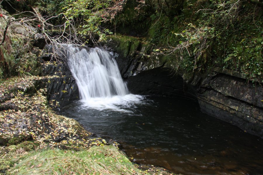
Take another track that heads above the trees to the left at the farm. This slowly descends to the river then turns a sharp right into the mouth of Cwm Gwesyn. At this point, Pwll y March is hiding in the river below, but is more tricky to reach, and should only be visited by experienced walkers. Continue on the track until you are upstream of the waterfall (there should no longer be a fence between the track and the river). Find a place where the river can be safely forded, and carefully make your way downstream on the other bank, until you reach the waterfall, which lands in an exceptionally deep scour pool.
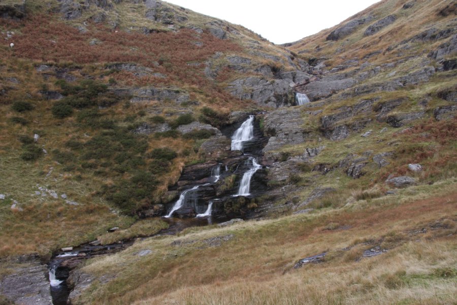
Return to the track, and follow it as it turns into a path. When this forks at the end of the fields, take the right branch, heading along the valley slightly further away from the river. Follow it for a little under 2 km to reach Sgwd y Ffrwd, a multi-tiered waterfall at the head of the valley. This is the end of the main walk, where the easiest route back is the way you came.
For experienced walkers, however, it is worth extending the walk as follows; ascend the path to the right of the waterfall, still heading up the main river. At the top, the path dies out, but roughly in the same direction as the river is the summit of Drygarn Fawr, the tallest of the Elan Valley mountains. Just keep heading in roughly that direction, towards the highest point, for 2 km. As a possible alternative route on the way back, head directly west from the summit, across the boggy ground to drop into the Nant y Rhestr valley. Follow it downstream to reach the path running on the left bank of the Irfon, at the point where it is joined by the Nant y Rhestr. Follow the path downstream through some forestry to reach the Irfon valley road. Follow that to the left to eventually arrive back in Abergwesyn, and turn left to arrive back at the parking area. I have not followed or graded this alternative extended route, but it creates a 17 km loop, of which 5 km is on roads, 5 km has no path, and 2 km shows as moorland marsh on the map.
| Waterfall | Grid reference | GPS coordinates | Image |
|---|---|---|---|
| Pwll y March | SN 85391 54383 | 52.175762°N, 3.677454°W | |
| Sgwd y Ffrwd | SN 86128 56133 | 52.191641°N, 3.667269°W | |
Whilst every care has been taken in the compilation of this description, neither the author nor his fellow walkers can accept responsibility for loss or injury arising from any errors, omissions or inaccuracies in this description. This description is intended as a guide only, and you should select a route to suit your own abilities, at your own discretion. Ability requirements are a guide only. Route maps are approximated. You follow this description at your own risk.