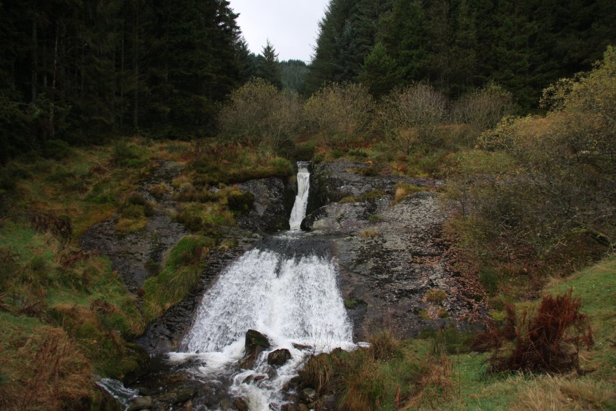
Including Rhaeadr Blaenhafren, Afon Hore Waterfall, Severn Cascades and Severn Break-its-neck.
From Cardiff, take the A470 to the Llangurig roundabout. From Llangurig, take the second turnoff (right) at the roundabout, continuing on the A470. After 4 miles turn left on the B4518 (signposted to Tylwch), and follow it into the Llanidloes town centre. From Llanidloes, turn left at the 400 year old Market Hall, towards the Hafren Forest (turn left after crossing the bridge). Follow occasional signs for Hafren for 7 miles to reach the picnic tables and forestry parking area at Rhyd-y-Benwch. SN 8573 8697.
There are many different ways through this forest, and many smaller walks and lengthy river walks are well established. Since it's easily possible to do so, I have prepared a route that takes in all of the main forest's waterfalls at once, roughly 12.6 km. There is also the option for the Severn Cascades alone, which is a specially prepared all-ability trail.
The only dedicated all-ability waterfall trail in the area, designed to be followed by wheelchairs. From the parking area head through the wooden arch onto the path that slopes down to the river. Turn right onto the raised walkway. The Severn Cascades are at its end. Turn right and follow the path up through the forest to arrive back at the parking area.
Two main paths lead off from the right side of the parking area (as seen from the entrance). The most obvious one has a large wooden arch. Take the path closer to the parking area entrance (to the right of the path with the arch), which leads off into the woods near to the road. Follow it for 300 metres to a junction with another path heading up to the right, when the main path starts to descend to the left. Take the path to the right and follow it up to a major forestry track which has another small parking area around the bend to the right. Turn left at the major track, taking the left fork when it splits almost immediately. Follow it for just over 2 km (passing a few minor tracks) to a major track junction. Take the left fork, dropping a little before climbing to Rhaeadr Blaenhafren on the right.
Continue past the waterfall, passing a path and track on the left. After 1.5 km it reaches another major track junction. Take the right fork then continue ahead at the next track junction. The track climbs up to reach the Afon Hore waterfall on the left, beside the remains of a small reservoir.
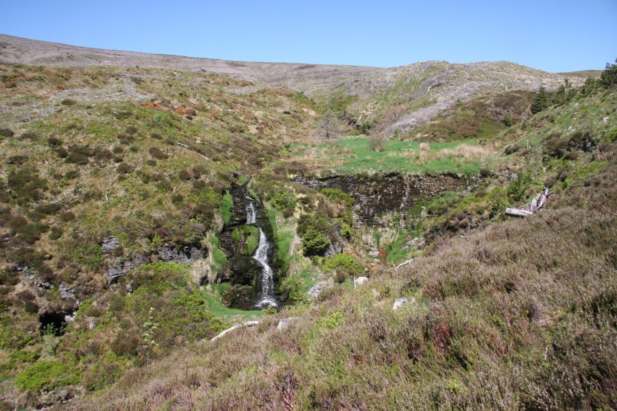
Turn around and almost immediately take a narrow path that forks off on the right. After 200 metres, another (artificial) waterfall falls into a gaping mine chasm behind a fence on the right. Although it is possible for experts to approach the chasm, perhaps even onto the rock bridge that spans it a little downstream, I would advise against that, as there are holes hidden under the heather that drop into the mine. Take great care.
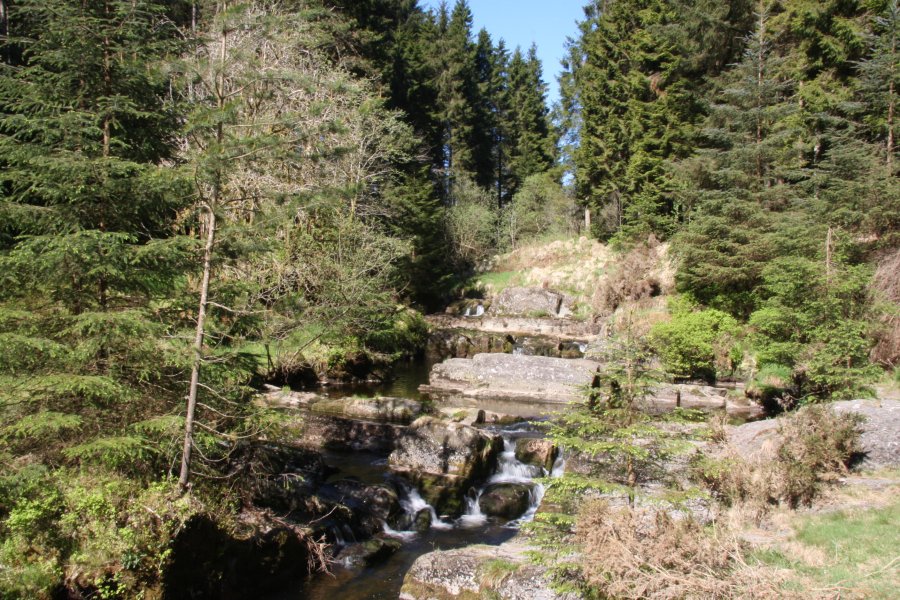
Continue past the mine buildings, eventually passing a flume before reaching a track. Turn right then immediately turn left onto another path. Follow the path down the bank of the Afon Hore. After 1.5 km it passes a small waterfall and flume, before reaching the junction with the River Severn. Turn left and follow the Severn to reach a footbridge. Cross the Severn and return down its far bank to the river junction, then continue down its bank (passing a track on the left) for 1 km until a very obvious raised walkway appears. The Severn Cascades are the minor steps in the river on the right. Follow the walkway until it ends at a junction with a track on the left, a ford on the right, a well-surfaced path ahead-left (the way back to the parking area), and a less significant path ahead-right along the riverbank.
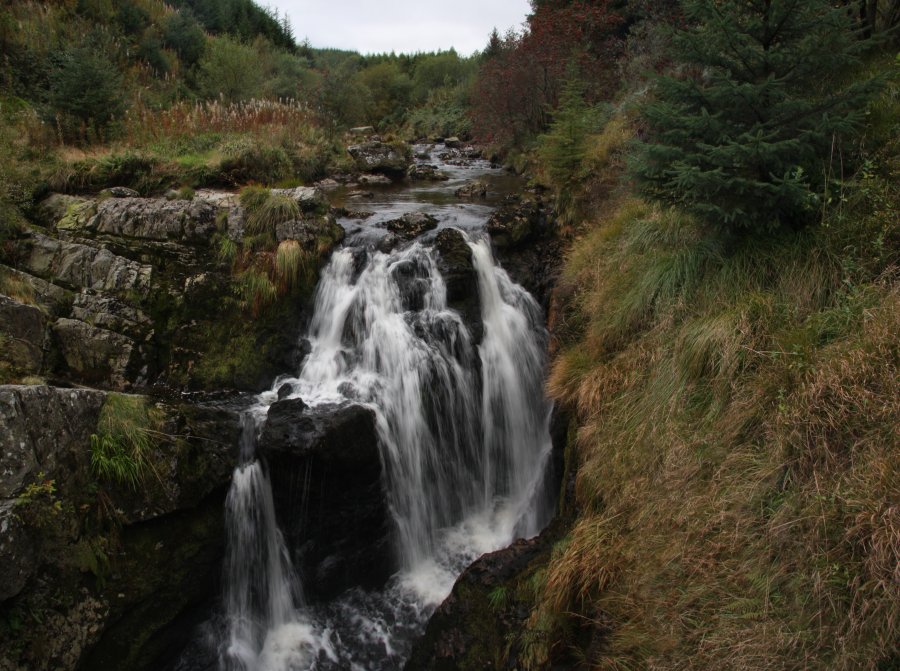
Continue ahead-right, following the waymarked path for the Severn Break-its-neck waterfall. It passes a bridge then climbs up to the left to a field. Follow the path that skirts the right edge of the field. Eventually this drops back to the river and passes through a forest to gain a major forestry track which crosses the river to the right. Turn left instead, following the track to stay on the left bank of the river. Remain with the track until you reach the Severn Break-its-neck waterfall on the right, and a footbridge crossing it. Cross the footbridge and turn right on the next track. Ignore two tracks on the right which cross the river again, and ignore a minor track on the left a while later. When the track forks immediately afterwards, head to the right, then close to the junction after that, follow a path heading down on the right to arrive at the bridge from the start of the Severn Break-its-neck trail. Cross it and turn left to reach the junction with the ford and walkway, and turn sharp right onto the well-surfaced path to head back up to the parking area.
| Waterfall | Grid reference | GPS coordinates | Image |
|---|---|---|---|
| Rhaeadr Blaenhafren/Blaenhafren Falls | SN 83567 88367 | 52.480766°N, 3.715895°W | |
| Afon Hore Waterfall | SN 82669 87692 | 52.474508°N, 3.728874°W | |
| Severn Cascades | SN 85371 87164 | 52.470338°N, 3.688930°W | |
| Severn Break-its-neck/Hafren-Torri-Gwddf | SN 86304 86732 | 52.466651°N, 3.675054°W | |
Whilst every care has been taken in the compilation of this description, neither the author nor his fellow walkers can accept responsibility for loss or injury arising from any errors, omissions or inaccuracies in this description. This description is intended as a guide only, and you should select a route to suit your own abilities, at your own discretion. Ability requirements are a guide only. Route maps are approximated. You follow this description at your own risk.