Including Pistyll Cain and Rhaeadr Mawddach.
From Cardiff, take the A470 past Dolgellau to Ganllwyd. Just as the road is about to leave Ganllwyd, where the village speed restriction is lifted, take a lane that forks off on the right beside a stone cottage. Keep right just after crossing a bridge, and after 1.5 miles, park at the Tyddyn Gwladys forestry parking area on the right. SH 7348 2631.
This walk takes in the two crown jewels of the Coed-y-Brenin Forest's waterfalls, and although they are usually sped past by cyclists, they are one of the forest's highlights for those who know how to look. (The name Coed-y-Brenin means The King's Forest - do you see what I did there with the name of the walk? OK great, let's carry on.)
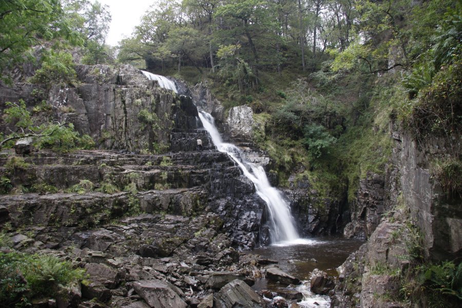
From the parking area, go back out onto the road and turn right, heading further up the valley. Stay with it as it turns into a dirt track. Keep to the left of some houses (where OS maps may show a footbridge, but it does not exist any more), then right when it forks, and remain on the dirt track for another 1 km to a junction of rivers. The impressive Rhaeadr Mawddach can be seen on the far river. Just up ahead, the river crosses a bridge. Pistyll Cain can be seen on the left here, although the view is quite obscured. Just after crossing the bridge, a very narrow path on the left gives the best view, which leads along a slightly exposed ledge to the base of the very impressive waterfall. However, it should be noted that this is not an official path.
Just before the bridge, experienced walkers may choose to cross the fence and take a small path up to the top of Pistyll Cain, where there is an upper bench of the waterfall. It is very slippery, and great care must be taken. There are also some smaller cascades upstream, but they are not really worth the effort needed to reach them. The upper bench can sometimes be seen through the trees from other parts of the walk.
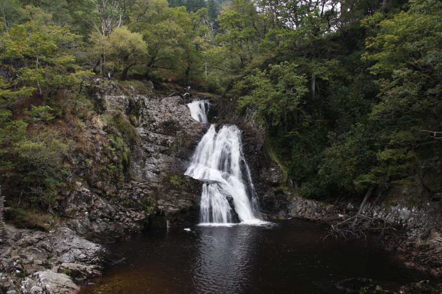
Back on the track, continue along it towards Rhaeadr Mawddach. Before reaching it, the remains of a gold mining site can be seen down a track on the right. For the best view of Rhaeadr Mawddach, follow the track through the gold mining site to locate a smaller path running to the right along the top of a cliff above the river's edge, heading away from the waterfall. Most of the buildings are fenced off, and the waterfall cannot be accessed from them. Return to the track and continue along it over the top of Rhaeadr Mawddach, where there is another viewpoint above the waterfall.
A little further along the track is a junction of tracks. Take the track to the right, which crosses a bridge over the river. On the other side, it turns right and climbs gently to a track junction. Turn right, and continue along the track. At various points, the upper bench of Pistyll Cain can be seen through the trees to the right, with the view being best in winter. A smaller waterfall is on the left side of the track after about 400 metres. At another track junction, go right.
The next turning you are looking for is to the right, after about 400 metres. Small paths may lead down to the right first (depending on what the cyclists have constructed by the time you visit). The path you want is on a right hand bend, where a branching path can also be seen joining from the left. On the bend, two paths join from the right, both of which descend to a lower path running below the track, the first of which doubles back to the right, and the second of which heads ahead-right immediately afterwards. Take the second of these paths to reach the lower path. Continue ahead-left to reach a footbridge. Cross the bridge, where the path then zig-zags and then heads to the right. When it branches, keep right and stay with an obvious path to arrive back at the parking area.
| Waterfall | Grid reference | GPS coordinates | Image |
|---|---|---|---|
| Pistyll Cain | SH 73391 27530 | 52.830373°N, 3.880700°W | |
| Rhaeadr Mawddach | SH 73579 27499 | 52.830139°N, 3.877899°W | |
Whilst every care has been taken in the compilation of this description, neither the author nor his fellow walkers can accept responsibility for loss or injury arising from any errors, omissions or inaccuracies in this description. This description is intended as a guide only, and you should select a route to suit your own abilities, at your own discretion. Ability requirements are a guide only. Route maps are approximated. You follow this description at your own risk.