Including Eglwys Faen Waterfall Entrance.
From Cardiff, take the A470 to the end of Merthyr Tydfil. From Merthyr Tydfil, take the A465 towards Abergavenny, and follow it to Brynmawr. If the A465 upgrade has been completed, exit the A465 at the Brynmawr exit, take the first turnoff to the left at the roundabout, and then turn right onto the Hafod road. If the A465 works have not yet been completed, turn right onto the A4047 at the Brynmawr roundabout (third turnoff), then after passing a zebra crossing, take the road that doubles back hard on the right, follow it until it crosses the A465, and the Hafod road is then the second road to the left. Follow the Hafod road for 3.5 miles, some distance after the second side road on the right, until a lane on the left climbs up to a parking area. SO 2091 1540. Be warned that car crime is extremely frequent here, and the parking area is not recommended as a result. Some distance further along the road, a track leads past houses ahead, while the road drops down to the right. Parking on the track is not allowed for regular visitors (only residents and cavers may park here, and one of the residents will make certain that you adhere to that rule), but you may be able to find somewhere to park further down the road.
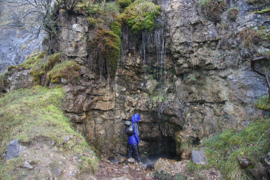
If you parked at the parking area, return to the road and continue along it to the track that continues ahead when the road descends to the right. The route starts at the track, and follows it, remaining almost completely level along the old quarry tramway, beneath the dramatic Llangatwg Escarpment. After a little under 1.5 km, it passes the multiple entrances of the Eglwys Faen cave system. The Waterfall Entrance is up a slope to the left at the start of the cave's entrances, where the waterfall falls over the entrance.
Beyond Eglwys Faen, the tramway continues, before the path splits. Take the path to the right, slowly dropping down the forested slope. When it splits part way down, take the left branch (the right branch ends up in the same place, but the left branch passes over the more dramatic scree slopes), to eventually reach some walls in a clearing. Turn right, and follow the walls, staying on the right bank of the stream. This slowly descends a series of cascades to reach a junction with a very steep tramway on the right, at the edge of a forestry plantation. Ascend the tramway. Half way up, it turns a corner to the left, then continues up to the main tramway, close to its start. Turn left to return to the start of the walk.
| Waterfall | Grid reference | GPS coordinates | Image |
|---|---|---|---|
| Eglwys Faen Waterfall Entrance | SO 19325 15647 | 51.833585°N, 3.172207°W | |
Whilst every care has been taken in the compilation of this description, neither the author nor his fellow walkers can accept responsibility for loss or injury arising from any errors, omissions or inaccuracies in this description. This description is intended as a guide only, and you should select a route to suit your own abilities, at your own discretion. Ability requirements are a guide only. Route maps are approximated. You follow this description at your own risk.