

Including Y Gerwn, Penbryn Waterfall, Tresaith Waterfall/Gwalia Falls and Glangraig Waterfall. A coastal walk taking in a small selection of the waterfalls in the area.
From Cardiff, take the M4 to Pont Abraham. Continue along the A48 to Carmarthen. Take the A40 through St. Clears, then near Narberth, turn right onto the A478 towards Cardigan. From Cardigan, take the A487 towards Aberaeron.
For Tresaith, after passing the second entrance to the B4333, take the back lane on the left that is signposted to Tresaith. The coastal path starts on the right just before the road slopes down to the tiny beach parking area. SN 2780 5152.
For Penbryn, continue along the A487 to Sarnau, and just as the village ends, take a lane that doubles back hard on the left just behind a church. Follow it down to Penmorfa, and turn left at the junction there. Take the next right, sloping down to a fork. Take the right fork, which is signposted to the beach. The parking area is shortly afterwards on the left, and a parking fee may sometimes be charged. SN 2961 5209. The path to Tresaith starts in the corner of the parking area. The path to Llangrannog starts as a grassy track on the right side of the road, just after the parking area.
For Llangrannog, continue along the A487 to Brynhoffnant, and turn left down the B4334 towards Llangrannog. Just after some tight hairpins, the free parking area is on the left. SN 3163 5384. (There is also a parking area at the bottom, but it has limited space, may require a fee, and misses out on the Llangrannog waterfalls, so it would defeat the purpose of starting here.)
This waterfall walk is quite unique for its setting; running along the coastal paths of Ceredigion, along the sea cliffs, and around the tidal beaches. The sea cliffs are particularly tall (over 100 metres). If you cannot cope with that, then this walk is not for you (though you could easily park at the parking areas right beside each of the waterfalls, and not bother to walk much at all). If the wind is blowing very strongly from the south or east, then the paths become quite dangerous. Then add the tidal effects - it is very important that you time your walk carefully around the tide in order to be able to see the Tresaith Waterfall/Gwalia Falls (which is the highlight of the walk), as it is only accessible at low tide. It is also only possible to take the beach alternative route (offered as an option on the way back) if the tide is particularly low. If the difference between high and low tide is only a couple of metres, then it may not be enough. I would suggest that a range of at least 3 metres is needed - this seems to happen for about 1 week out of every fortnight, but you should check the tide predictions to make sure. It is very easy to get yourself marooned on the tiny bay just east of Tresaith, so don't take chances.
If starting at Llangrannog (7 km before Tresaith), I would estimate that most walkers should start at least 2 or 3 hours before low tide. If starting at Penbryn (2.8 km before Tresaith), then I would estimate that they should start at least 1 or 2 hours before low tide. If starting at Tresaith, then I would estimate that they should start at least half an hour before low tide. If spending any time at Tresaith, then this time must be accounted for by starting earlier. I recommend starting at Llangrannog, as it gives a nice place to rest and have refreshments at the end of the walk, though it is usually quite busy. You can check the tide time predictions for the nearby Aberporth station on the government EasyTide site. Note, however, that these cannot take into account all situations (they do not take storm surges into account, for example), and it is up to you to assess the situation for yourself and decide if the tide is low enough for you to complete the route, or if you should take the alternative route that is not affected by the tide.
The main part of the walk is 12.9 km in length, and the optional extension adds another 6.8 km, bringing the total to 19.7 km. It might be best to do these as two separate walks.
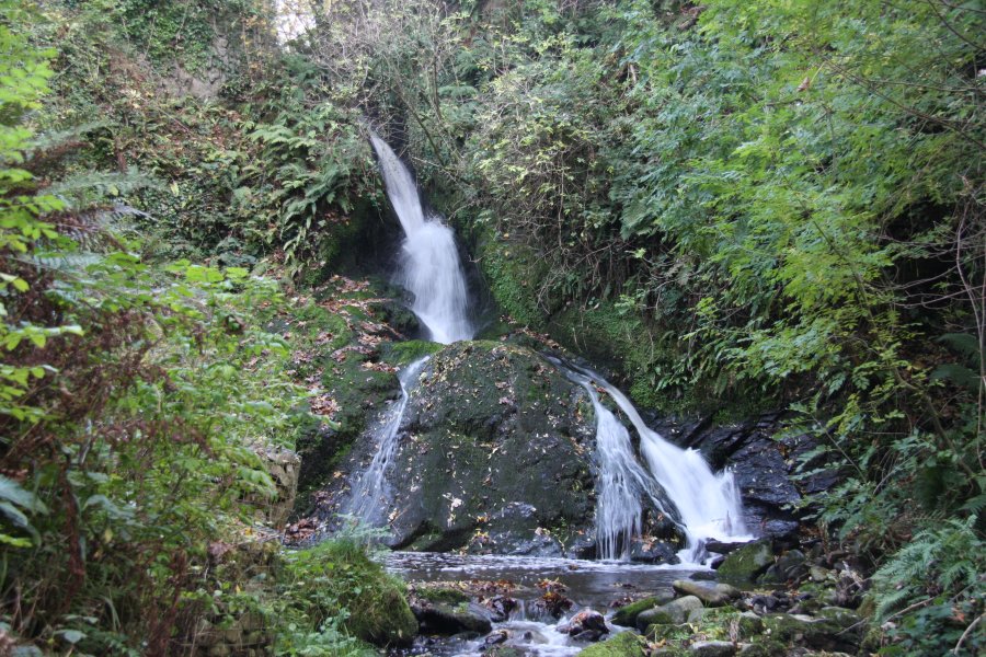
From Llangrannog, walk down the last part of the B4334 until it joins another road - the B4321. Turn left. The road soon passes over the top of Y Gerwn, the Llangrannog waterfall. The view is a little poor from here, so if you're adventurous, there is a community garden just before it. At the back of the community garden is a gap in the hedge (used for disposing the lawn cuttings), where it is possible to walk through a small woodland to the bottom of the waterfall's gorge to see it properly from below. Just below the gorge is a 3 metre waterfall right beside the remains of the old mill house, but note that the mill is on private land, and the plunge pool is deep. Back on the road, continue along it as it descends steeply down to Llangrannog Beach and associated businesses. It's best to save your exploring of this interesting little beach until you return, or you may end up missing the low tide at Tresaith. Take the road running around the left side of the beach. It swings right and climbs over an old lime kiln, then swings very hard left. On this bend, the coastal path starts ahead-left. Take it.
Follow the path as it hugs the cliff edges, and then starts to climb quite steeply up cattle fields. (Dog walkers do frequent this area, but I will always recommend that you keep dogs away from cattle, and despite what the signs say, do not keep the dog on a lead if the cattle become interested in the dog, or you will end up getting trampled.) The path breaks out into the open and runs along the edges of some very tall cliffs, upto about 115 metres tall. When the path splits with one route heading along the edge of a field to the left, continue ahead along the fence near the cliff edge. It swings left and starts to descend, eventually zig zagging down into the steep Morfa valley. Cross the stream via a bridge and continue up the other side of the valley (the stream edge can be followed down to a tiny beach, with some cascades as it tumbles down to the sand, but this is not really enough of a waterfall to be included in this walk). After wandering around the steep edges of the bay, the path then resumes its normal direction along the tall cliffs - the same height as before, but not so exposed. When it reaches a junction with a dirt track, turn right, and follow the track as it swings down to reach a farm at Penbryn. Go through a gate on the right side of the farm to reach the beach road. Turn left to reach the Penbryn parking area.
From Penbryn, take the footpath at the back of the parking area down the steps to a stream. On the left, the stream tumbles down a pretty little waterfall. To get a better view, you can walk up the left bank for a short way, but note that the waterfall itself is on private land, which has been sympathetically fenced off to allow nice pictures without needing to walk onto the private land. Cross the stream via the footbridge, and climb up the stepped path on the other side, turning right when you reach the wall. The path then forks, where the right fork may be used to walk down to the beach (this can optionally be used on the return journey), and to the left is the way on. The path immediately forks again, with left heading up to a church, and right being the way on.
After skirting the edge of the woodland, the path breaks out into the open, and begins the clifftop route. Ignore the beach path on the right, and continue through some fields and along the clifftops. These are not as steep as before, but rise to over 120 metres, and the undergrowth can easily hide the steep edges. Take care, and keep to the path. Eventually, the path swings around some bends and drops down steps to reach the roads at Tresaith. Turn right and take the stepped path through the houses down to the beach.
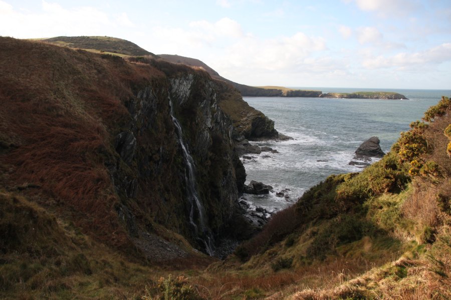
From Tresaith, head out onto the beach. On the right side of the beach is a rocky outcrop, and just beyond that, tucked out of sight from the beach, is the Tresaith Waterfall/Gwalia Falls. The outcrop is normally accessible at mid and low tide, but to reach the waterfall itself, low tide is needed. There is now an optional route back to Penbryn, requiring low tide. Continue past the waterfall to a tiny bay, and beyond that along the rocky shore to the long Penbryn beach. When you reach the beach road, take the footpath on the right side of the road that crosses the stream via a footbridge. Continue along the path that heads up the right side of the stream, as it climbs up through the woodland. Ignore the path that heads up to the right. Eventually, the path is joined by another from the right (the path to Tresaith), and then it swings down to the left to cross another bridge, and climb back up to the Penbryn parking area. If the tide is not low enough, return to Penbryn via the same paths as on the way out.
Back at Penbryn, the simplest approach is to return to Llangrannog using the same paths as on the way out. If you want something with a little more variety, the pickings are quite slim, as the only approach is to cross farmland. This part of the route is described in the assumption that you will carry and follow a map (paths are marked on the 1:25'000 maps). Head along the first part of the coastal path (on the other side of the road from the parking area), past the farm. Then as the track swings left, take a footpath to the right. It climbs up to a farm. Skirt the farm on the left, staying on the grassy track as it joins the farm's track. When the track then swings right, take a footpath ahead into a woodland. After following the edge of a stream for a while, it swings around a little before joining a road at Penmorfa.
(From here on, I have not followed this path, but assume that the paths marked on the map exist.) Turn left and walk uphill past a small church, ignoring a road on the left. At the next farm on the left (Cnwcyrhyglyn), stay on the road to pass the first farm house, then head through gates into the farm yard between two farm houses. The field you want to get into should be directly ahead, but the farm has been rearranged since the OS maps were made. To get in there now, turn left in the farm yard, and head along the track, then take a track heading to the right to get into the field. (You could also get there by taking the track on the left side of the road just before the farm buildings, turning right after the buildings, then taking a left when it forks. This may be considered more polite to the farmers since it does not pass through their private yard, but the official right of way heads through the farm yard, so in theory it is the way you are supposed to go.) Aim diagonally over the field to its far corner, then diagonally over the next long field (shown as two fields on the map) to reach the road by Rhyd-lŵyd.
Cross the road into the field on the opposite side. Follow the hedge on the left for three fields, then cross over a stream into another small field at the back of the Eisteddfa farm. Skirt the left side of the farm to reach a short track that ends at a more significant track. Turn left and follow it in approximately the same direction as the previous hedgerows. It passes a track to the left then enters a field. Follow the right side of the field to reach a woodland. Descend through the woodland to a narrow lane. Turn right and follow it as it swings left to join the B4334. Continue ahead to reach the Llangrannog parking area, which is now on the left.
Back at Llangrannog, there is an optional extension that can be used to access the final waterfall, but this does add a significant distance onto the walk; it might be nicer to do this as a separate walk on its own. If you have returned to the parking area at Llangrannog, return to the B4321 and turn left, then take a lane that climbs gently to the right, shortly after passing Y Gerwn. If you have come back via the beach instead, ascend the road to reach the track (or follow the extension in reverse). Take the right branch when it splits, to reach a sharp bend to the left overlooking the far side of the Ynys-Lochtyn peninsula. The coastal path joins and leaves the track on the bend. Take the coastal path that continues ahead, following the coast to the right. It soon passes a shortcut on the left (which can be used later, ignore it for now), skirts some fields, then arrives at the Urdd Centre - identified by its dry ski slope.
At the Urdd centre, continue along the coastal route, heading steeply down to the cliff edges (there is a waterfall hiding under the path at this point, but it is extremely dangerous to approach, and should only be viewed from a boat). The path then cuts along the bottom of some fields, and crosses a stream. Shortly afterwards, it skirts a tiny bay, where the stream can be seen falling down the Glangraig Waterfall. Though there is another waterfall just beyond this, and a further little waterfall at Trwyn Crou, these are extremely dangerous to approach from above, and should only be viewed from a boat.
If you want an alternative route to return to Llangrannog, return to the shortcut, and follow it to cut off a long corner of the coastal path. Follow the coastal path around the headland, ignoring paths on either side which branch off to head down the peninsula, and then also ignore one that climbs up to the left (this regains the track after passing through a farm). Stay near the top of the cliffs until the path descends to Llangrannog beach. It is time for those well-earned refreshments.
| Waterfall | Grid reference | GPS coordinates | Image |
|---|---|---|---|
| Y Gerwn | SN 31521 54045 | 52.158900°N, 4.464415°W | |
| Penbryn Waterfall | SN 29610 52049 | 52.140386°N, 4.491322°W | |
| Tresaith Waterfall/Gwalia Falls | SN 27930 51683 | 52.136577°N, 4.515661°W | |
| Glangraig Waterfall | SN 32881 55231 | 52.169967°N, 4.445137°W | |
Whilst every care has been taken in the compilation of this description, neither the author nor his fellow walkers can accept responsibility for loss or injury arising from any errors, omissions or inaccuracies in this description. This description is intended as a guide only, and you should select a route to suit your own abilities, at your own discretion. Ability requirements are a guide only. Route maps are approximated. You follow this description at your own risk.