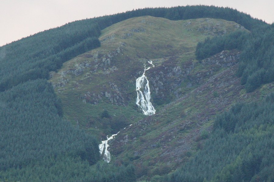
Including Rhaeadr y Carreg Wen and Maesglase Waterfall.
From Cardiff, take the A470 to Dinas Mawddwy. From Dinas Mawddwy, continue towards Dolgellau along the A470, from the far end of the village for 0.7 miles to the junction with the first road on the left. For Maesglase Waterfall, follow the little lane to the left (with obscured views of the main waterfall), until it drops to cross a stream. There is a small amount of space to park just before crossing the stream. SH 8395 1514. Rhaeadr y Carreg Wen can be clearly seen on the mountainside ahead at the A470 junction, but for the best view, continue ahead to the next layby on the right, which has a post box. SH 8414 1614.
After dry weather, the waterfalls can almost disappear, and being north-facing, the main one is badly affected by sunlight. I suggest following this route after plenty of rain (but see the note about the ford below), on a day with complete cloud cover, and a high cloudbase.
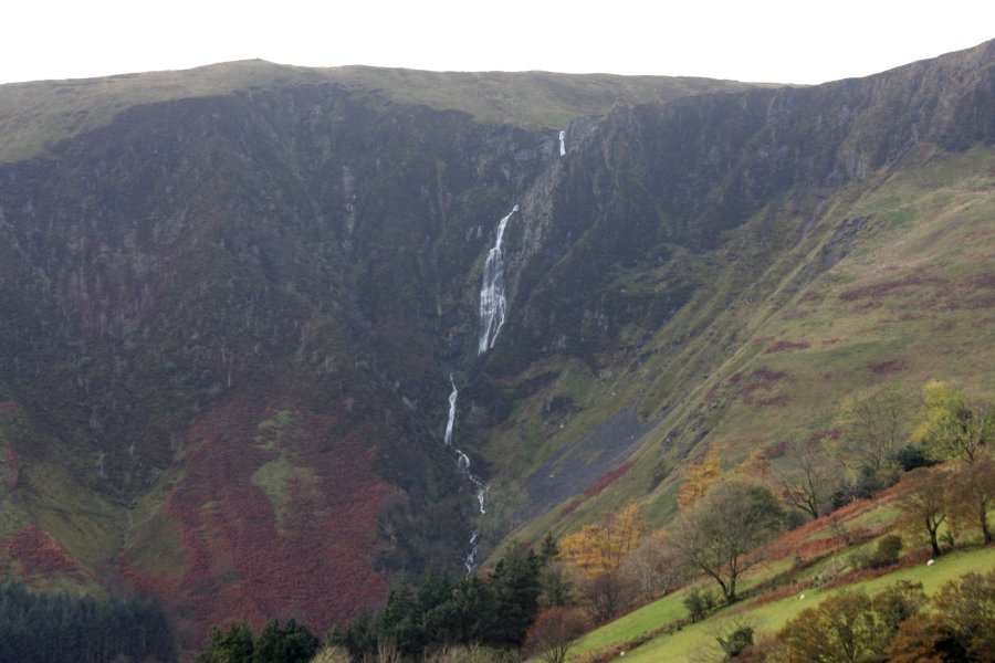
Head back up the lane, away from the stream, until a grassy track doubles back on the right. Take it out into the fields. Maesglase Waterfall dominates the view at the end of the valley, dropping down several steps. The total descent is about 160 metres, making it equal tallest in total height of all waterfalls in Wales. In fact, as virtually all of that is proper waterfall, it almost certainly deserves the title more than Pistyll y Llyn. Its tallest single drop is a very respectable 85 metres, and the second tallest is 34. This is a very impressive waterfall, over twice as tall as the better known Pistyll Rhaeadr, with a single drop height alone that is greater than Pistyll Rhaeadr's total height. But I digress.
Beginners should turn around now. Experienced walkers, follow the track all the way up the valley, until it passes a forest, then fords a (potentially dry) stream. It then reaches a ruined old mining building (the failed Red Dragon gold mine), followed by the remains of a smaller ruin (a third ruin lies in the stream valley below), beneath the Bwlch Siglen mountain pass. Ignore a path sloping down to the right shortly after the second ruin, and after another 100 metres, look for a less obvious path heading down to the right, aiming for the upper edge of a tiny forestry plantation (the earlier sloping path also reaches it, and could optionally be used instead).
Optionally the path continuing to climb up to the pass can be used to extend the walk, if conditions allow. Paths are not well maintained, and a map is required. At the pass, it reaches forestry, and follows the right side of it, heading up to the right. Near the top of the forestry, where there are no official paths, it branches off to the right, staying close to the top of the Craig Maesglase cliff (be very careful), passing over a tributary stream, and then over the top of the waterfall. Beyond there, the path can be followed along the edge of the Craig Maesglase escarpment, then along the top of the Cwm yr Eglwys escarpment, where Rhaeadr y Carreg Wen can be seen across the valley, to a path junction and fence at the Maen Du summit. Turn left to follow the fence, along a path that soon becomes a poor quality track. After 400 metres, it crosses the fence. Cross the fence and continue along the other side of the fence, and keep an eye out for a path on the right which leads to a tiny cairn about 100 metres away, at the top of the Maesglase mountain, above the Craig Rhiw-erch escarpment. Return to the fence and track, and continue along it, turning left on the track when the fence turns left. Cross fences as needed to run along the left side of the main fence heading back towards the forestry above the Maesglase Waterfall (a well worn track runs on the right side of the fence for some of its length). Just before the forestry, descend the edge of the forestry to the left, regain the path heading down from the Bwlch Siglen pass, and return to the path junction near the mine ruins.
Back on the main route, follow the less obvious path to skirt the left side of the tiny forestry plantation. Immediately after passing the forestry, enter the edge of a field ahead-right. Cross the field diagonally ahead-right, following a path that becomes more obvious, running parallel to the stream on the right, and aiming a little below the next tiny forestry clump ahead (the clump near the top of the field, not the one down in the stream valley below). Just before it reaches the wall below the forestry clump, the path turns right, descending towards another forestry clump in the stream valley instead. 50 metres further down, it turns left through a gateway to enter the top of another field. Follow the top edge of the field, to gain a track running along its top. At the end of the field, the track passes into the grounds of the old Maes-glase-bâch farmhouse on the left, which sits below the immense Maesglase Waterfall. Follow the track to ford the stream (take great care in high water), and turn right on the track to follow the stream downstream. Keep left when the track forks, and follow the track down to the farm. Follow the road out of the farm, which swings down to cross the stream at the start of the walk.
| Waterfall | Grid reference | GPS coordinates | Image |
|---|---|---|---|
| Rhaeadr y Carreg Wen | SH 82943 17355 | 52.741109°N, 3.735351°W | |
| Maesglase Waterfall | SH 82713 14063 | 52.711479°N, 3.737579°W | |
Whilst every care has been taken in the compilation of this description, neither the author nor his fellow walkers can accept responsibility for loss or injury arising from any errors, omissions or inaccuracies in this description. This description is intended as a guide only, and you should select a route to suit your own abilities, at your own discretion. Ability requirements are a guide only. Route maps are approximated. You follow this description at your own risk.