Including Melincourt Falls.
From Cardiff, take the M4 to junction 43, and take the A465 to the right towards Merthyr Tydfil. At the first roundabout that interrupts the A465, turn right on the B4434 into Resolven. Follow it as it turns right, and reaches Melincourt. Shortly after passing the village sign, there is a parking area to the right, opposite the Melincourt O.A.P. Hall. SN 8218 0198.
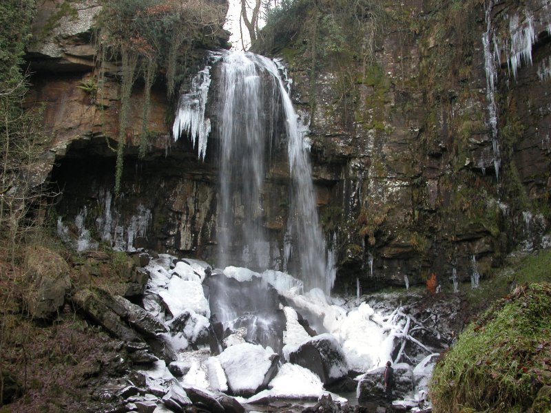
Directly opposite the parking area, to the right of the O.A.P. hall, is the path leading into the nature reserve. Follow the path, which remains on the right bank of the river, up to the very impressive Melincourt Falls. A second waterfall is on the right, which normally appears as just a mossy dribble.
Return back along the path towards to start of the walk. After about 100 metres, a small path on the left leads up the bank, which can in theory be used to complete a loop, though I have not followed it. As it climbs, the early part of the path heads downstream, before swinging back around to the left to head back upstream (where another path joins from the right). Follow it to the top of the waterfall. It then joins another path which runs along the edge of the reserve's boundary, along the remains of a tramway. (To the left it joins a lane that runs above the waterfall.) Follow this tramway path to the right. (At one point, it passes a path to the right, which leads back into the reserve to join the climbing path, creating a smaller loop.) The path then drops down into the Neath valley, crossing the driveway for a nearby house, and passing under some electricity wires. At this point, a path (which may be overgrown) heads down to the right. This descends down to the road at the start of the walk.
(On the far bank of the stream, a stile enters the reserve from the lane above, and in theory this could be used to create a loop. This path shows on the map as making its way down to the road at the bottom, passing through a small group of houses. I have not followed this part though, and it looked fairly overgrown, and probably not worth the effort.)
| Waterfall | Grid reference | GPS coordinates | Image |
|---|---|---|---|
| Melincourt Falls/Melincwrt Falls/Sgwd Rhyd-yr-Hesg | SN 82571 01652 | 51.701286°N, 3.700653°W | |
Whilst every care has been taken in the compilation of this description, neither the author nor his fellow walkers can accept responsibility for loss or injury arising from any errors, omissions or inaccuracies in this description. This description is intended as a guide only, and you should select a route to suit your own abilities, at your own discretion. Ability requirements are a guide only. Route maps are approximated. You follow this description at your own risk.