
Including Diffwys Dwr and Pistyll Gwyn - Afon Las.
From Cardiff, take the A470 to Betws-y-Coed. From Betws-y-Coed, take the A5 towards Bangor. Follow the road to the far end of the lengthy village of Capel Curig, then turn left onto the A4068, signposted to Caernarfon. After passing the lakes, turn right by the Pen y Gwryd Hotel to remain on the A4086. It climbs to the high point at Pen-y-Pass - the head of Nant Peris - where there is parking space if needed (it fills up very quickly, as this is the start of many Snowdon routes). Continue past Pen-y-Pass, and park if possible in the first lay-by on the left - this also fills up very quickly. SH 6284 5668.
All waterfalls on this walk can be visited on-road. There are no dedicated proper paths running down the valley (the mountains are all open access wilderness, so paths are not needed), and this does mean that it is possible to drive the entire route - this is often how these waterfalls are seen, while on the way to one of the other waterfall sites further along in the valley. If walking, be warned that this is a very busy and very popular road, and you will share it with numerous vehicles. If you can cope with walking without well-maintained paths, you are best off trying to follow a poor path along the slopes above the right side of the road, ascending the bank to a ladder stile when a fence blocks the road-side path after 1 km, and descending on the other side to join the road.
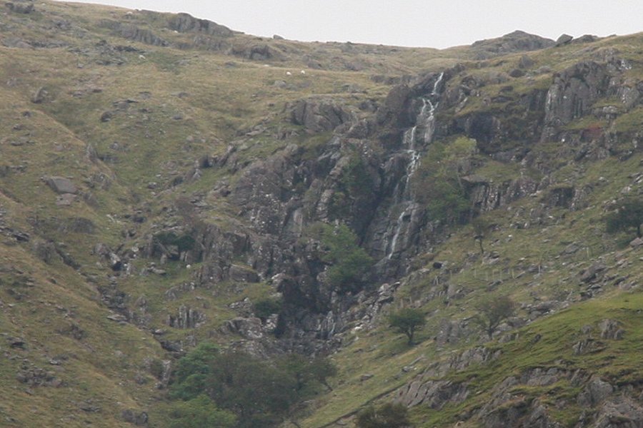
Walk downhill along the road. The first large valley on the left, Cwm Glas Mawr, has numerous little waterfalls (and various paths used by climbers to reach the crags). One of the large crags on the left about half way up the valley contains Diffwys Dwr. In most conditions, it just looks like a 61 metre black smudge down the cliff, but in winter it can freeze into a spectacular ice display.
Continue down the valley until you reach some houses on the right. High on the crags above them is Pistyll Gwyn, with the best view being from a bus stop shortly afterwards. Return using the same route, or catch the bus up to Pen-y-Pass.
If you want to extend the route, there are possibilities, but I have not followed these extensions, and their grading has not been confirmed.
For getting closer to Diffwys Dwr; take the second track on the left from the lay-by, cross the bridge, take the right fork and cross the next track bridge. Turn left after the bridge to follow the path along the riverbank. Continue as far as you want to go up the valley. Once you are level with the waterfall, you can ford the stream near a moraine, and the one after it (now without any path), to reach the base of the waterfall.
For getting closer to Pistyll Gwyn; just after the houses on the right, there is an alcove on the right side of the road with a bus stop, postbox and three gates. Go through the middle gate and follow the track until it dies at a house. Pass the house on the left. Continue upwards through fields towards the tree-lined stream, to locate another path running along its right bank. Follow it upwards around several rocky outcrops, crossing a tributary stream, to reach the waterfall (or even continue onwards to the Devil's Kitchen).
| Waterfall | Grid reference | GPS coordinates | Image |
|---|---|---|---|
| Diffwys Dwr/Craig y Rhaeadr | SH 62040 56116 | 53.084386°N, 4.061251°W | |
| Pistyll Gwyn | SH 62230 58085 | 53.102123°N, 4.059261°W | |
Whilst every care has been taken in the compilation of this description, neither the author nor his fellow walkers can accept responsibility for loss or injury arising from any errors, omissions or inaccuracies in this description. This description is intended as a guide only, and you should select a route to suit your own abilities, at your own discretion. Ability requirements are a guide only. Route maps are approximated. You follow this description at your own risk.