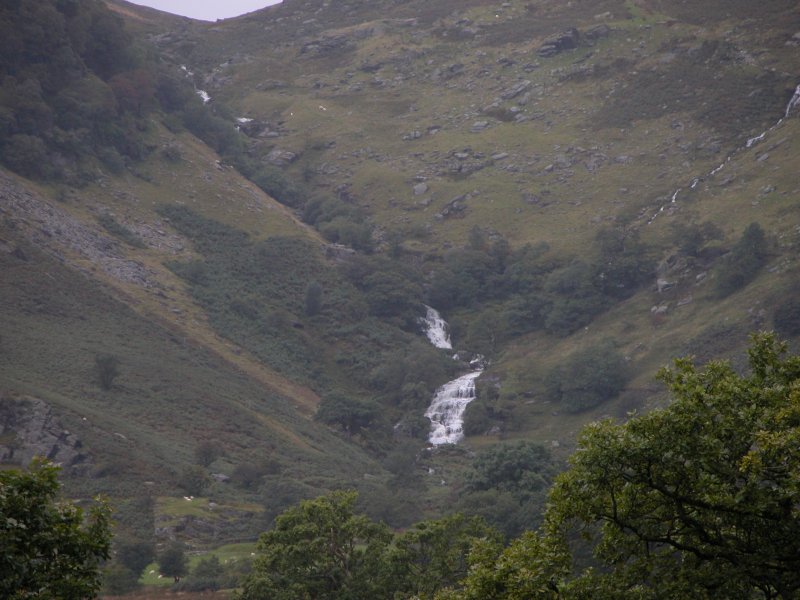
Including Nant y Sarn Falls.
From Cardiff, take the A470 to Rhayader. From Rhayader, choose the road view, or walking route.
For the road view, continue along the A470 (signposted to Newtown). After 2.5 miles, part way around a sustained right bend, there is a house on the left, and a track on the right that may be used to stop temporarily. SN 9476 7109.
For the walking route, turn left onto the B4518 at the wonky junction with the clock tower in the Rhayader town centre, towards the Elan Valley. At the edge of Rhayader, turn right onto a lane, signposted to Aberystwyth. Take the first right. After about 2.5 miles, it reaches the Nannerth Country Holidays cottage cluster, at a point where the road passes through a gate. Shortly afterwards is another gate, with a grassy track doubling back through a gate on the left before it, and another track with a footpath heading ahead-left after it. Park in one of the road-side spaces. SN 9478 7162.
For viewing from the car, the Nant y Sarn Falls can be seen on the far side of the valley from the A470 stopping point. They will be much more apparent after heavy rain.
For the walk, take the first grassy track (the one without a footpath sign) heading back along the road, which appears to be a concessionary path. Stay beside the line of fields, passing two farms. At the second farm, a path ahead can be used to reach the bottom of the waterfalls, and a path branches up to the right, climbing above the waterfall. Follow the path up as far as needed to get the desired views.
There is an optional looping route for more experienced walkers. Follow the path all the way up to the corner of a field and the remains of the Lluest-pen-rhiw farm. Take the path heading through the field, past the remains of the farmhouse, and continue beyond the field to reach another path at a stream. Take it to the right, and follow it above the farm's field, up over some crags, then down the ridge to reach some fields (it splits a few times; try to keep to the main path running along the ridge towards the junction of the Nant y Sarn and Wye valleys). Enter the corner of the first field, then after a short distance, go left into the next field. Cross it to the far end, to the right of a mast. At the far end is a track which zigzags down to the second track at the start of the walk. Note; I have not followed this route, so be prepared to use your own initiative, and follow the 1:25'000 scale map.
| Waterfall | Grid reference | GPS coordinates | Image |
|---|---|---|---|
| Nant y Sarn Falls | SN 93492 71305 | 52.329464°N, 3.564377°W | |
Whilst every care has been taken in the compilation of this description, neither the author nor his fellow walkers can accept responsibility for loss or injury arising from any errors, omissions or inaccuracies in this description. This description is intended as a guide only, and you should select a route to suit your own abilities, at your own discretion. Ability requirements are a guide only. Route maps are approximated. You follow this description at your own risk.