Including Rhaeadr Nantcol.
From Cardiff, take the A470 to the Llanelltyd roundabout, just past Dolgellau. From Llanelltyd, take the first turnoff (left) onto the A496 towards Barmouth. Follow it past Barmouth to Llanbedr. From Llanbedr, after crossing the stone bridge, turn right, signposted to Cwm Nantcol and Rhaeadr Nantcol. After passing through Pentre Gwynfryn, turn right at the next junction and left at the one after that, each time following signs for Cwm Nantcol and Rhaeadr Nantcol. For restricted access and paid parking, follow the lane until a sign points down a private lane to the right, leading to the dedicated parking area. SH 6076 2706. For open access and free parking, follow the public lane past the access lane for the private parking area. After passing through the farm complex at Cefncymerau Uchaf, park near the last, solitary barn on the left. SH 6122 2731.
The paid parking area is attached to a campsite, and has time restrictions to preserve the quiet atmosphere - no access before 10:00, or after closing time. The parking fee is also excessive - there are popular places in Snowdonia where you can park and camp for less than the parking fee for a short day-trip to the waterfalls. The parking area is also often unmonitored, so you are paying only to park, not for someone to protect your belongings. You may choose to park in one of the passing spaces back down the public road to avoid having to pay this fee, but you will still have to pay a fee to walk through the site. There is a public right of way on the far bank, and this was sometimes used via a concessionary footpath to view the waterfalls, but the concessionary footpath access has been revoked (as of 2009). If you want to visit the site for free, follow the instructions given below.
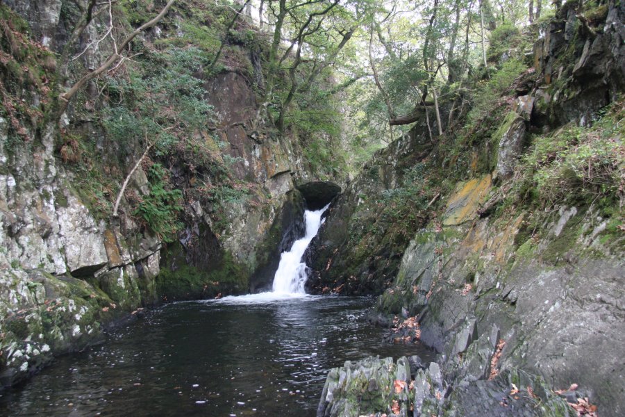
From the parking area, head to the river (to the right when looking into the parking area from the lane). Follow the river bank upstream through the campsite, to a stile into open access land. (That's what you had to pay for; to walk through a campsite.) Up ahead, you can see the lower cascades at the mouth of the gorge, and get a view of the bigger Rhaeadr Nantcol waterfall inside the gorge. Use the path on the left side of the river to get above the gorge. Do not attempt to look down into the gorge from here, the edge drops off very suddenly, and fatal accidents have occurred. Stay on the clifftop path to get to the upper edge of the gorge, where there are some beautiful cascades. Beyond here, the river becomes more gentle. Stay on the path nearest the river, and follow it as the river bends to the left. Shortly afterwards, the river can be seen flowing down a series of small cascades. Return the same way.
From the barn, use the gateway opposite the barn to get into the fields. Head to the right of the rocky outcrop along a track. When the track swings hard right near its end, continue ahead to pick up the path. Follow it through the edge of the woodland. Ignore paths leading down to the right, and try to hold roughly the same direction through the outcrops, curving a little to the left to reach the path by the stream without losing too much height (perhaps ascend a little outcrop to get a better idea of your progress).
Wherever you meet the stream, head downstream along the path that runs as close to the stream as possible, to reach the top of the gorge, where there are some cascades. Follow the path above the gorge to its far end. Do not attempt to look down into the gorge from here, the edge drops off very suddenly, and fatal accidents have occurred. At the far end of the gorge, the path drops down to river level, where you can see the lower cascades at the mouth of the gorge, and get a view of the bigger Rhaeadr Nantcol waterfall inside the gorge.
Return the same way, staying with the stream long enough above the gorge to see the upper cascades, a short distance after the stream bends to the left.
| Waterfall | Grid reference | GPS coordinates | Image |
|---|---|---|---|
| Rhaeadr Nantcol | SH 60859 26778 | 52.820526°N, 4.066265°W | |
Whilst every care has been taken in the compilation of this description, neither the author nor his fellow walkers can accept responsibility for loss or injury arising from any errors, omissions or inaccuracies in this description. This description is intended as a guide only, and you should select a route to suit your own abilities, at your own discretion. Ability requirements are a guide only. Route maps are approximated. You follow this description at your own risk.