Including Rhaeadr Ogwen, Cwm Cneifion Falls, Devil's Appendix and Devil's Kitchen.
From Cardiff, take the A470 to Betws-y-Coed. From Betws-y-Coed, take the A5 towards Bangor. Follow the road through Capel Curig and onwards into the mountains, to the end of the Llyn Ogwen lake. At the end of the lake, turn left onto a lane signposted as a parking area, and park in the parking area on its sides. A fee is charged for parking. SH 6493 6037. (There are also several lay-bys that can be used for free parking along the edge of the lake.)
Although less experienced walkers may be capable of following a large part of this walk, it's important to note that this is serious mountain terrain, and suitable equipment is essential. The weather in this area can turn bad quite suddenly, and map reading skills are needed for when this happens. This walk is best undertaken on a day with good weather shortly after prolonged rain, to allow the smaller streams to fill up.
If you have parked in an earlier lay-by, walk along the roadside to the parking area at the end of the lake.
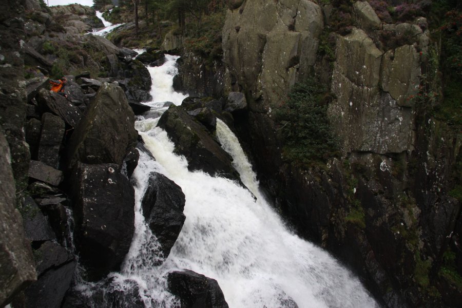
Rhaeadr Ogwen is an immense chain of waterfalls, best seen from two separate vantage points. Firstly, follow the lane through the parking area. Shortly after passing over a cattle grid, experienced walkers can start looking for somewhere to descend the slope on the right towards the river, taking care to avoid the crags. The river emerges from a gorge where Rhaeadr Ogwen thunders its way down into the massive Nant Ffrancon valley. Less able walkers should continue down the road for 700 metres, past some scout huts to a grit bin on a small rise, where the lower steps of the waterfall can now be seen from the road.
Return to the parking area, and out onto the main road. Turn left and follow it for 150 metres, to see the upper steps of Rhaeadr Ogwen creating a beautiful display on the left as it heads into the gorge. A gateway just beyond the bridge provides access to a ledge closer to the waterfalls and crags. On the opposite side of the road are some more cascades that can be seen from the road (it's also possible to cross a stone stile opposite the gateway to view the remains of the old bridge, perched under the current one).
Return to the parking area again to begin the main walk. A major path begins on the left side of the parking area's visitor centre, heading away from the lake. Follow it past a cleft on the right, to climb up the first bench of the hillside. When the main path swings right and another one continues ahead, stay with the main path, following it up to the Llyn Idwal lake, one of the most dramatic places in Snowdonia.
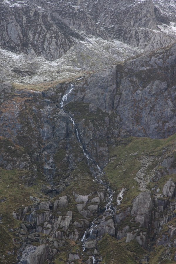
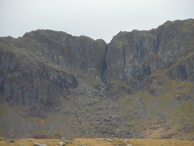
At this point, several waterfalls are visible, though you may have a hard time concentrating on them given the impressive surroundings. On the left is the Cwm Cneifion hanging valley on the face of Glyder Fawr, and the Cwm Cneifion Falls are the waterfalls spilling out of it. To the right of that, a very obvious ribbon of white water is an unnamed stream, almost certainly one of the tallest white water streams in Wales (about 300 metres), but with only a few relatively small waterfalls. On the right of that is a long cliff, with the deep Devil's Kitchen gorge in its centre - the waterfall in it may be seen from further along the path. To the right of the gorge is the Devil's Appendix waterfall, usually a black smudge on the cliff, but in the right flow it shows up as a 93 metre single drop waterfall, the tallest in Wales - it also freezes into a beautiful ice display in suitably cold winters. Various other black smudges on the left of the gorge also have waterfalls, but none as big or impressive.
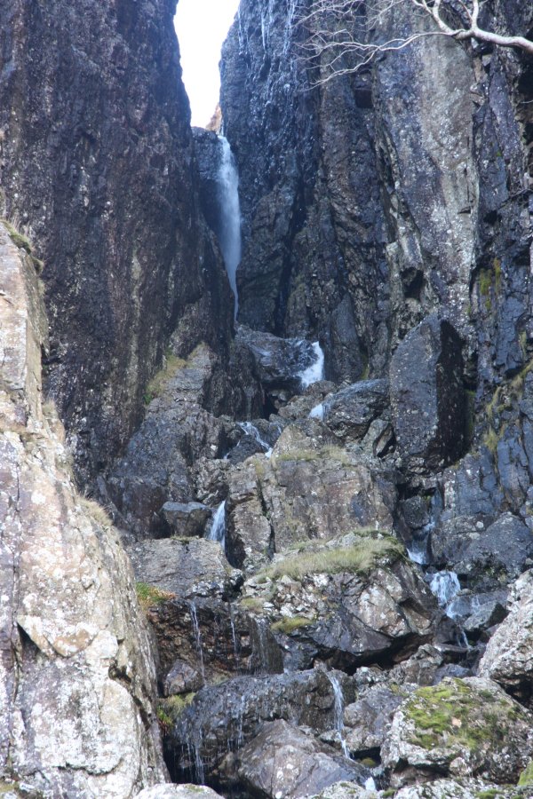
The path continues to circle the lake. At the far end, it passes an optional shortcut to the right that reaches the path on the other side of the lake, without visiting the higher waterfalls, crossing the streams lower down using stepping stones - this should be used by walkers who are not capable of ascending the bouldery steps ahead. The main path climbs higher, crossing a bridge over the white water stream. (Until 2018, this was a ford, which was quite tricky and slippery, especially after rain. The bridge is most welcome, and makes this section much safer.) After crossing the stream, the main path reaches a very rocky section, and starts to climb. Part way up this, another path joins from the right - remember this path. Continue upwards until the path passes just below the mouth of the gorge. It's possible to get a good view of the Devil's Kitchen waterfall by standing on the rocks to the right.
At this point, there is an optional detour for experts. Ignore the path, and scramble up the gorge - it's roughly a grade 1 scramble. A lower waterfall is reached below the main one, where it is possible to walk behind the waterfall, and another waterfall behind that first one. Return to the mouth of the gorge.
There are no further waterfalls from here, so the route is now to descend back down the rocky path to the previous junction, and take the other path (now to the left) down to the other side of the lake. At this point, the shortcut arrives from the right. Contine around the left side of the lake all the way to the outflow, and cross the footbridge to join the main path used earlier. Turn left and follow the path back to the start of the walk.
For experienced mountain walkers there is a suggested extension that is quite a popular route - this guide does not cover it in detail, and if you plan on following the route, you should use a dedicated mountain walking guide. It is not included in the grading of the waterfall walk. Continue up the path from the Devil's Kitchen to the pass above. Turn left and follow the path up onto Glyder Fawr. Follow the route over the rocky ridge to Glyder Fach. Take the path that heads down the scree on the far left side to Bwlch Tryfan. Turn left and head to Llyn Bochlwyd, then ford its outflow. Follow Nant Bochlwyd down its cascades, before heading over to the junction with the main path near the outflow from Llyn Idwal. Continue ahead to reach the start of the walk.
| Waterfall | Grid reference | GPS coordinates | Image |
|---|---|---|---|
| Rhaeadr Ogwen | SH 64809 60527 | 53.124720°N, 4.021795°W | |
| Cwm Cneifion Falls | SH 64725 58930 | 53.110353°N, 4.022376°W | |
| Devil's Appendix | SH 63866 58906 | 53.109918°N, 4.035190°W | |
| Devil's Kitchen/Twll Du | SH 63825 58807 | 53.109018°N, 4.035760°W | |
Whilst every care has been taken in the compilation of this description, neither the author nor his fellow walkers can accept responsibility for loss or injury arising from any errors, omissions or inaccuracies in this description. This description is intended as a guide only, and you should select a route to suit your own abilities, at your own discretion. Ability requirements are a guide only. Route maps are approximated. You follow this description at your own risk.