Including the Pistyll Rhaeadr waterfall, which is not the tallest waterfall in Wales.
From Cardiff, take the A470 to Builth Wells, then the A483 past Welshpool to Llynclys Crossroads. From Llynclys Crossroads, turn left onto the A495 signposted to Llansantffraid. After just over 2 miles, continue ahead on the B4396 to Llanrhaeadr(-ym-Mochnant), when the A495 turns left off itself. From Llanrhaeadr-ym-Mochnant, after passing the Wynnstay Arms pub, and the triangle of roads at the village square, turn right onto Waterfall Street, signposted to the waterfall. After 3.5 miles, there are some large lay-bys for parking available on the roadside in view of the waterfall, but these usually fill up quite quickly. SJ 0764 2936. The privately operated visitor centre just beyond it also has a parking area, where a fee is charged for parking.
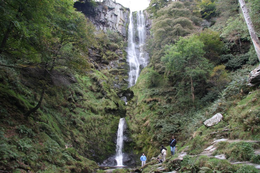
Try to ignore all of the propaganda that claims that this is the highest or tallest waterfall in Wales. It is surpassed by several other Welsh waterfalls in both the tallest single drop and tallest total drop, for waterfalls of various types, including the same plunge type. It is not the highest in altitude, and it does not have the highest flow rate. It is a very pretty waterfall, with a very nice natural arch on the middle drop, but it serves as a tourist trap, and can become extremely busy. The tallest waterfalls can be seen on my lists.
To get to the base, continue along the road. Head through the visitor centre's parking area towards the stream. A path starts near the building on the left (and another starts near the information shelter), heading upstream to the base of the Pistyll Rhaeadr waterfall. From there, a bridge crosses the stream and the path can be followed down the valley, but that route is not included in this walk.
To get to the top, take the side path opposite the bridge (staying on the same bank as the visitor centre, not crossing the bridge), that heads into the forest, away from the river. This is joined by some paths on the right as it passes the visitor centre. Continue just inside the bottom of the forest until the path leaves the forest, where it splits, with the right path joining a track. Follow the path up to the left, which climbs steeply up some zigzags. When the path rejoins the track further up, turn left onto the track. 150 metres after the path and track rejoin, another path leads off on the left through a gate and a woodland, to the top of the waterfall. Take care, it's a long way down. Return to the track and turn right to head back down. This time, stay with the track, around a hairpin bend, until it reaches the forest at the bottom. Take the path to the right (the zigzag path joins from the right), and after passing through the first part of the forest, take a path to the left that passes through a stone gateway to reach the road by the visitor centre's gateway. Turn left to return to the start of the walk.
For more experienced walkers, the track at the top can be used to reach the mountains, or via a path to cross the river. The following suggestion is one possible route, which I have not followed, and you will need to have a map for.
Continue along the road towards the visitor centre's parking area. Just before the gate leading into the visitor centre parking area, a path leads up to the right, heading away from the river. Pass through a stone gateway, and another path joins from the left as the path enters the forest. Continue just inside the bottom of the forest until the path leaves the forest, where it splits, with the right path joining a track. Follow the path up to the left, which climbs steeply up some zigzags. When the path rejoins the track further up, turn left onto the track. 150 metres after the path and track rejoin, another path leads off on the left through a gate and a woodland, to the top of the main waterfall. Take care, it's a long way down. Return to the track and turn left, heading upstream along the hanging valley above the waterfall.
Just upstream, the walled woodland, which surrounds the head of the waterfall, ends. Just upstream of that is a small clump of trees in the river, followed by a longer clump of trees in the river. Beside the longer clump, the path splits. Instead of following either branch, head down a sheep track sloping down the bank towards the river. Ford the river upstream of the trees, and head up the opposite bank to a fence. Turn right (upstream), and follow the fence to a lonely clump of trees at the corner of the fenced area.
Turn hard left into the fenced area at the trees, aiming back downstream along the valley. There is a diagonal fence running between the two outer fences. Keep to the left side of it, following it all the way to the edge of the crags, on the right side of the open valley ahead. Various paths join from the right as the path skirts a dry valley. By the next little valley, the path has become a track. A set of small waterfalls are tucked into the valley below the path, take great care if trying to get a view. Stay with the track as it passes over a moorland then zigzags down into the next hanging valley. As it reaches the lip of the hanging valley, there is another little waterfall tucked down in the stream on the right. Take care if trying to get a view.
The track turns left to face back up the main valley again and descends its steep side. Not far from the bottom, it turns a hairpin bend to the right. 200 metres further on - 100 metres before it is joined by two other tracks - a path doubles back on the left. Take the path, following it past some old mining buildings, to skirt the top edge of a walled field. Soon after the path crosses a stream (the one with the set of small waterfalls from earlier), another more significant path begins to develop a little lower down on the right, immediately above the fields. It doesn't matter which path you choose to use, as they end up in the same place. The paths finally join on the opposite side of the river from the visitor centre. A little way further on, the combined path swings right to cross the river using a footbridge, at the base of the Pistyll Rhaeadr waterfall. Turn right on the path at the other side of the bridge, and follow it to the visitor centre. Leave the visitor centre along the access road, to return to the start of the walk.
| Waterfall | Grid reference | GPS coordinates | Image |
|---|---|---|---|
| Pistyll Rhaeadr | SJ 07265 29502 | 52.854996°N, 3.378657°W | |
Whilst every care has been taken in the compilation of this description, neither the author nor his fellow walkers can accept responsibility for loss or injury arising from any errors, omissions or inaccuracies in this description. This description is intended as a guide only, and you should select a route to suit your own abilities, at your own discretion. Ability requirements are a guide only. Route maps are approximated. You follow this description at your own risk.