Including the immense Rhaeadr y Cwm waterfall.
From Cardiff, take the A470 to Llan Ffestiniog. From Llan Ffestiniog, immediately before passing under the railway bridge at the start of the village, turn right onto the B4391, signposted to Bala. After climbing up the hillside, the road approaches the edge of the deep Cwm Cynfal valley, where there is a parking area on the right. SH 7346 4176.
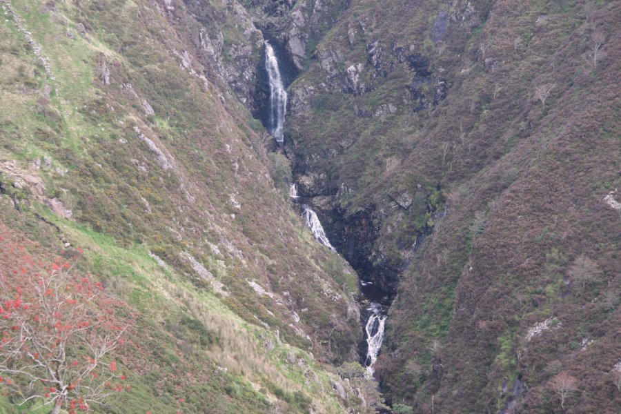
Walk out of the parking area, turn right, and walk along the edge of the road. On the next left bend there is a viewpoint on the right, reached down some steps, looking over the Rhaeadr y Cwm waterfall. The vast majority of this enormous waterfall can be seen from here (most can even be seen from the road itself), and only the top step is hidden.
If you would like a closer look, continue along the road for 700 metres to a gate on the right with a footpath sign. Go through the gate and follow the path leading back to the right, diagonally across the field to reach the fence above the start of the waterfalls. Follow the fence line until it develops into a wall. From here, though the path is well worn, it is exposed, and more suitable for experienced walkers. It heads away from the wall along an obvious ledge, part way down the crags, towards a large flat-topped outcrop below the previous viewpoint. It crosses the outcrop to its far side, and descends beside a stream to the bottom of the valley.
I have not followed the paths here, but if you wish to extend the walk, the following route would be my suggestion; a map is required. Turn right into a field. Follow the bottom edge of the field, and the one after it, skirting the right edge of a wall that surrounds Cwm Farm, to gain a track. Continue downstream on the track, along Cwm Cynfal, for 1.5 km, to reach Bron Erw farm. Part way along, it is joined by another track from the left, and becomes a proper paved lane.
Just before Bron Erw farm, turn right onto a track. Pass through the Bryn Mawr farm, continuing uphill on a track between two fields. After the field on the right ends, turn right into the bottom of the next field, beside a ruin. Aim up the field, a little to the right of the direction that the track had been heading, to reach the the upper wall, then follow the wall to the right into the far top corner. At the end of the field, cross the wall into the next field, then turn left to follow its left wall up the field. Pick up a faint track to veer away from the left wall and pass through a gateway into a smaller field. Near its far corner, join a much more substantial track, and follow it ahead to the B4391. Turn right to get back to the parking area.
| Waterfall | Grid reference | GPS coordinates | Image |
|---|---|---|---|
| Rhaeadr y Cwm | SH 74006 41684 | 52.957684°N, 3.877065°W | |
Whilst every care has been taken in the compilation of this description, neither the author nor his fellow walkers can accept responsibility for loss or injury arising from any errors, omissions or inaccuracies in this description. This description is intended as a guide only, and you should select a route to suit your own abilities, at your own discretion. Ability requirements are a guide only. Route maps are approximated. You follow this description at your own risk.