Including Rhaeadr Gwy and Nant Gwynllyn Falls.
From Cardiff, take the A470 to Rhayader. From Rhayader, turn left onto the B4518 at the wonky junction with the clock tower in the town centre, towards the Elan Valley. After crossing a stone bridge, take the second left onto a wide lane, where there is a parking area on the left which is the start of the walk. SN 9674 6778.
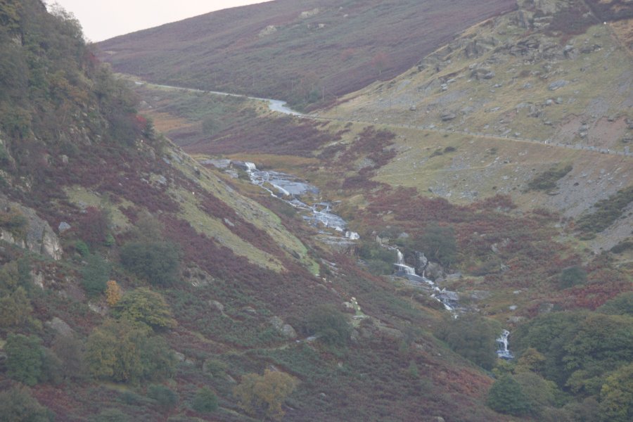
If you would prefer to drive to the viewpoint for the Nant Gwynllyn Falls, continue past the parking area. At the edge of Rhayader, turn right onto a lane, signposted to Aberystwyth. Follow it to a cattle grid. From here on, the waterfalls can be seen from various points at the end of the valley, including when the road is directly above them. SN 9506 6894.
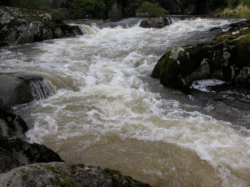
Continue down the lane past the parking area, passing a small back alley on the left. Turn left onto a lane that joins from the left, then immediately take a path heading off on the right towards the river. The waterfall, or at least the remains of it, lie immediately upstream, below the stone bridge. Sadly very little remains of the waterfall itself, which was largely destroyed in 1780 in order to build a bridge.
Optionally, it is possible to walk to the Nant Gwynllyn Falls. To keep distances short, a lot of this route will use minor roads, but it is possible to use various footpaths if you are willing to add on extra distance (left as an exercise to the reader). Head back to the parking area, and turn left on the B4518. At the edge of the town, turn right onto a lane, signposted to Aberystwyth.
Take the first left to cross the river, then follow the road as it loops around a house (passing a lane on the left), eventually heading around to the right. After a little over 1 km, it forks, with the road continuing to the left, and a farm track and footpath to the right. Follow the farm track to the farm. In theory you should turn right and walk through the farm yard onto the path, but the farm layout has now changed, and you may have to go around the back of the barn into the open access land and turn right to gain the path. Continue beyond the farm on the path that stays at the bottom of the open access land, just above the fields. This slowly climbs up into the Nant Gwynllyn valley beside the Nant Gwynllyn Falls.
About half way up the waterfalls (most of the top ones are just waterslides), a path heads off to the right, crossing the stream, then climbing up to the road on the other side. Turn right and follow the road for about 3.5 km to arrive back at the edge of Rhayader. Turn left onto the B4518, to arrive back at the parking area.
| Waterfall | Grid reference | GPS coordinates | Image |
|---|---|---|---|
| Rhaeadr Gwy | SN 96830 67848 | 52.299034°N, 3.514352°W | |
| Nant Gwynllyn Falls | SN 94165 69478 | 52.313176°N, 3.553930°W | |
Whilst every care has been taken in the compilation of this description, neither the author nor his fellow walkers can accept responsibility for loss or injury arising from any errors, omissions or inaccuracies in this description. This description is intended as a guide only, and you should select a route to suit your own abilities, at your own discretion. Ability requirements are a guide only. Route maps are approximated. You follow this description at your own risk.