
Including Nant Bwa-drain and Rheidol Falls.
From Cardiff, take the A470 to the Llangurig roundabout. From Llangurig, take the first turnoff (left) at the roundabout, onto the A44 towards Aberystwyth. After passing the pestrol station in Capel Bangor, take a left at the junction signposted to Cwmrheidol. After passing the start of the Cwm Rheidol Reservoir, park in the visitor centre parking area on the left. SN 6972 7958.
This description may be over-simplified, as I have not followed the complete route myself - it was created using various maps and satellite imagery, largely following the popular Rheidol Valley Circular Walk. Take a map with you, and prepare to use your own initiative. If you would prefer to use a comprehensive description, Des Marshall's book Walking to Mid Wales' Waterfalls describes a similar walk in reverse that also follows the Rheidol Valley Circular Walk route - note that it misses out on the waterfalls on the Nant y Fawnog.
Head out of the parking area onto the road. Turn left and follow the road. (The Rheidol Valley Circular Walk climbs a forestry track from the car park instead, then takes a footpath back to the road, but this adds effort without any waterfalls, and is therefore not part of this route.) After 1.5 km, at the end of the Cwm Rheidol Reservoir, it passes a path to the right leading to a footbridge. Ignore this for now, it will be visited later. 2 km later, the road reaches another footbridge on the right, which will be the way on. Before crossing it, take a quick detour a little further up the road to reach a 2-step cascade in the river, and another single cascade a short distance upstream.
Now return to the footbridge downstream of the cascades, and cross it into a field. On the far side, follow the left side of the field upwards until a path leads out of the field on the left. Follow it out of the field, to where it forks immediately. Experts can follow the left branch to climb up to the Vale of Rheidol Railway (ignoring a path to the right near the top), then follow the edge of the railway line to reach the Nant y Fawnog stream, where some unnamed waterfalls are hidden below - approach with extreme care, then return to the fork. The right branch is the main way on. Follow the right branch up, taking every right turn, to reach the top of the fields.
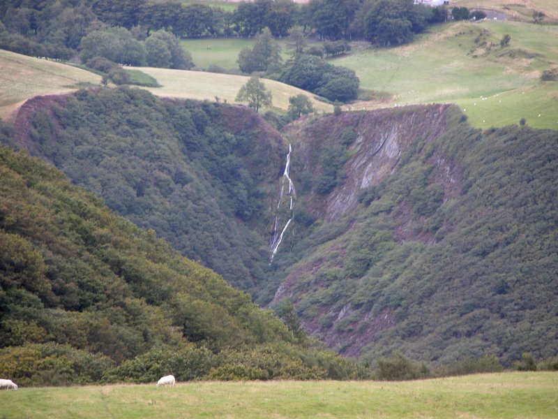
Follow the main path running along the top of the fields (downstream along the valley), ignoring any side paths, until after nearly 2 km, it arrives at some mining buildings and lime kilns. At various points along the path, look up into the valley on the right, which contains the Nant Bwa-drain waterfall at its head. In the next field after the limekilns, head over to the river, where there is a weir and salmon leap, marking the end of the reservoir. Just downstream is a footbridge crossing the reservoir's head. From that bridge, you get a great view of the Rheidol Falls tumbling into the reservoir, below the weir. This used to continue below the current water level, and its height is roughly halved by the reservoir.
Return to the fields, and pick up a path that climbs up to the top edge of the fields, away from the river. Continue downstream, passing the remains of another building, where the path splits. The right branch follows a line of trees that separates fields, while the left branch heads up into the edge of the forestry. Both paths end up in the same place, but the lower one is preferred, as it runs close to the reservoir for longer. Whenever there is a choice of route, take the right branch to remain closer to the reservoir. The path gains a track after about 750 metres, and is joined by other paths and tracks as it makes its way downstream along the edge of the reservoir.
After 1 km, the track ends at a road. Turn right and follow the road to cross the bridge over the Afon Rheidol. On the right is the Felin Newydd Falls weir, and the Cwm Rheidol Reservoir dam. Looking up the river towards the dam, on the hillside in the distance is a small patch of mining debris whose shape supposedly resembles a stag when viewed from this point, so it is locally known as The Stag. Turn right at the road junction on the far side of the river, to return to the start of the walk.
| Waterfall | Grid reference | GPS coordinates | Image |
|---|---|---|---|
| Nant Bwa-drain | SN 71534 79163 | 52.395365°N, 3.889438°W | |
| Rheidol Falls/Ffrwd-ddu | SN 70940 78891 | 52.392781°N, 3.898058°W | |
Whilst every care has been taken in the compilation of this description, neither the author nor his fellow walkers can accept responsibility for loss or injury arising from any errors, omissions or inaccuracies in this description. This description is intended as a guide only, and you should select a route to suit your own abilities, at your own discretion. Ability requirements are a guide only. Route maps are approximated. You follow this description at your own risk.