Including Rhuddnant Gorge Falls.
From Cardiff, take the A470 to the Llangurig roundabout. From Llangurig, take the first turnoff (left) at the roundabout, onto the A44 towards Aberystwyth. At Ponterwyd, turn left on the A4120 towards Devil's Bridge. From Devil's Bridge, turn left onto the B4574 towards Cwmystwyth. After 2 miles, there is a parking area next to a very obvious stone arch on the left. SN 7654 7555.
This route is heavily inspired by the Pen y Garn route in volume 1 of John and Anne Nuttall's guide to The Mountains of England and Wales, which provides the most interesting way to visit the area. For more details see that book. The waterfalls form a significant extension to that route, taking it from 10 km to a little over 13 km.
The parking area's track splits into three just inside the entrance. To the left is the parking area. In the middle is the main forestry track, running along the side of the parking area. On the right is a minor track. Follow the main forestry track that runs along the side of the parking area, ahead at a cross roads, and stick with it as it climbs to a crest. Depending on the tree felling status, there may be good views over the Ystwyth valley on the right, and the Mynach, Rheidol, and Rhuddnant valleys on the left. Tracks join from the left, then right, then right again, but these can be safely ignored. It then climbs up again to a higher crest. At the second crest (150 metres after the track splits then rejoins), you may want to walk down through the trees to the left, to the top of the Craig y Ceffyl cliff (take care), which gives a view over the Rhuddnant Gorge. A little further along the track, a minor track leaves on the right, and the main track reaches the start of the Cefn Croes wind farm.
As you pass the first line of wind turbines, a track joins from the right; the Pen y Garn track. Continue ahead, passing a mini-track and single turbine on the left, to reach another track junction. On the left is a turbine spur track, leading past two more turbines, while the track ahead is the moorland track. The turbine spur track on the left used to continue to the Nant Rhuddnant, but the second part of this is now overgrown. However, it is still the easiest way down to the river, avoiding the surrounding bog. There is no path down the gorge, so don't expect this part to be too easy. Take the spur track and ford the river. (I have crossed this river after plenty of rain but if you are worried about water levels, continue along the moorland track to a bridge over the river, then take lefts at each track junction to get to the far bank, adding 1.25 km to the route in each direction.)
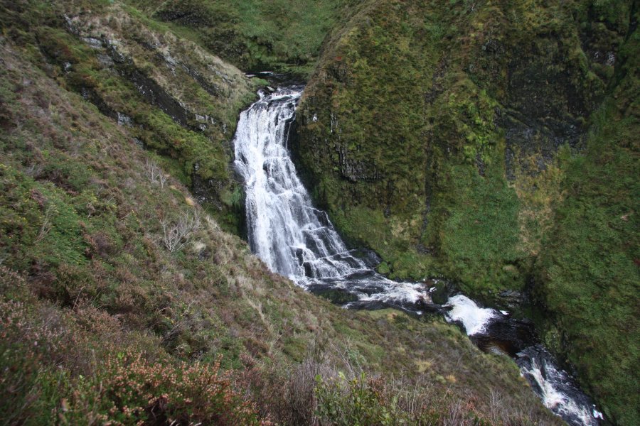
Once you have crossed the river, head downstream very carefully along the top of the gorge, until you get a good enough view of the watefalls (the bottom one is the largest, at 15 metres in a single drop). Beyond here, the dramatic cliff develops into Craig y Llyn, but there are no more major waterfalls, so head back to the junction with the Pen y Garn track.
Return to the track junctions and take the gated Pen y Garn track around to the far side of Pen y Garn (the summit on the right side of the track). Just after passing through one of the gates on the far side of the summit, cross a stile on the right and follow a footpath up to the top. Just before the summit is another track, with the way down to the left. Visit the stone windbreak on the summit, then head down on that upper track. Turn right when it rejoins the lower track, and follow it down a series of zigzags. Another track then joins from the right, and another one forks off to the left. Ignore both, and continue on the now-level track to the edge of a forest (trees may have been felled), where the main track turns right at a junction. Take the track to the left instead, which skirts the forestry to reach a road.
Turn right onto the road, and immediately right again back off it, onto a poor quality forestry track. Cross a better quality track after 400 metres, and continue on a very poor quality track to reach another proper one. Turn left, then double back on the right onto a side track leading to a farm. Follow it past the farm, and continue for some distance to a major cross roads (the same crossroads from the start of the walk). Turn left to arrive back at the parking area.
| Waterfall | Grid reference | GPS coordinates | Image |
|---|---|---|---|
| Rhuddnant Gorge Falls | SN 80167 78420 | 52.390648°N, 3.762364°W | |
Whilst every care has been taken in the compilation of this description, neither the author nor his fellow walkers can accept responsibility for loss or injury arising from any errors, omissions or inaccuracies in this description. This description is intended as a guide only, and you should select a route to suit your own abilities, at your own discretion. Ability requirements are a guide only. Route maps are approximated. You follow this description at your own risk.