Including both the tourist site, and a free alternative.
From Cardiff, take the A470 to Betws-y-Coed. From Betws-y-Coed, take the A5 towards Bangor. For the tourist site, after a couple of miles, park at the Swallow Falls Hotel on the left. SH 7658 5771. For the free alternative, continue past the Swallow Falls Hotel until the road crosses a bridge. Take the road ahead just after the bridge, beside The Ugly House. Follow the lane up to the Ty'n Llwyn viewpoint and parking area. SH 7655 5835.
The tourist site is run as a commercial venture, and a fee is charged for entry. The fee has in fact been so profitable that the village paid off large debts and enjoyed decades of reduced utility rates, thanks to the income from it. You may consider it to be excessive for a natural feature to be used so directly to make large profits, so there is the alternative free route below.
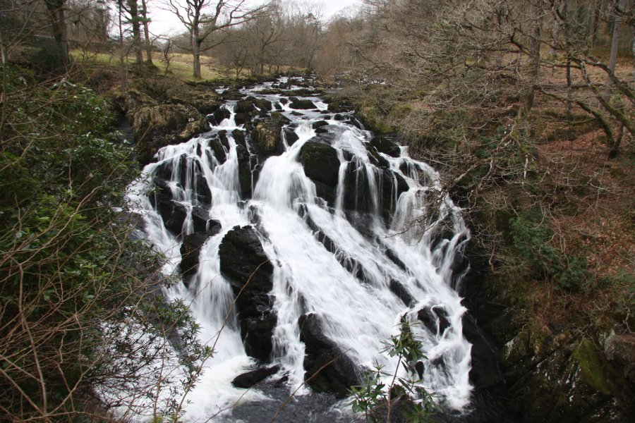
For the tourist site, go through the entrance opposite the hotel. Follow one of the paths down to the left to see the classic view of the graceful upper waterfall. Follow one of the paths down to the right to see the lower waterfalls. Note that the platform at the end of the lower path can be completely covered with water when the river is in full flood.
At the top of the parking area, a path heads back into the forest, staying near the road's wall. For its entire length, the 3.7 km route is marked with yellow route markers. The path soon reaches a junction. Continue ahead. The path swings left, then drops through the forest to cross a forestry track, and eventually reach a second one. Turn left onto the track, then immediately take the right track when it forks. Follow the track until it ends, and the main path continues. A side path soon afterwards to the right gives a closer view over the top of Swallow Falls. Continue on the main path, to a viewpoint down on the right, giving the best view over the top two stages of the waterfall (best seen in winter, when the foliage has died back).
Return to the path just above the viewpoint, and continue along it below a tall cliff, and above a fenced drop to the river. The lower cascades can be seen from the path. At the end of the cliff, take a track to the left. Just before crossing a stream, turn left onto another track that climbs up to a junction with a larger track. Turn right, then turn left onto a stepped path before the next stream. The path ascends some small rocky patches, and swings around a few times to reach a larger rock outcrop on the left. Ascend the outcrop to a viewpoint over the valley, with Moel Siabod and the distant Snowdon mountain range to the right. The path continues past the viewpoint, climbing up to the junction from the start of the walk. Turn right and follow the path to the parking area.
| Waterfall | Grid reference | GPS coordinates | Image |
|---|---|---|---|
| Swallow Falls/Rhaeadr Ewynnol | SH 76451 57734 | 53.102454°N, 3.846841°W | |
Whilst every care has been taken in the compilation of this description, neither the author nor his fellow walkers can accept responsibility for loss or injury arising from any errors, omissions or inaccuracies in this description. This description is intended as a guide only, and you should select a route to suit your own abilities, at your own discretion. Ability requirements are a guide only. Route maps are approximated. You follow this description at your own risk.