
Including Pistyll Blaen-y-cwm, Pistyll Cablyd, Pistyll y Gyfyng and Afon Eirth Falls.
From Cardiff, take the A470 to Dolgellau, then the A494 to Bala. From Bala, take the B4391 over the plateau to Llangynog. For walking to Afon Eirth Falls, park at a lay-by near a track, just before descending from the plateau into the valley. SJ 0195 3005. For the main walks, take a look over your shoulder when dropping down from the plateau into the valley, as the Afon Eirth Falls can be seen from the road. At Llangynog, take the narrow lane signposted to Pennant Melangell and Saint Melangell's Church. Follow the lane to Saint Melangell's Church, and park in the carpark beside it. SJ 0245 2650.
Note that this was, in our previous experience (2009-2010), the least welcoming valley in Wales. A number of the landowners did not like visitors, and had gone to great lengths to prevent visitors from crossing their land. Many areas had signs trying to dissuade visitors from using legitimate paths or driving down legal highways, several legal footpaths had been left to decay without signs or proper access, and some legal footpaths had even been revoked. This guide attempts to avoid the problem areas we experienced, and other visitors have reported that the routes described here presented no access problems in 2016; many areas had improved signage. It is essential that you take a 1:25'000 scale map which shows the rights of way, and that you treat landowners with respect. There are two route options, with the longer route being suitable only for more experienced walkers.
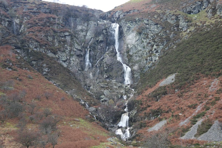
From the church, continue along the lane for 400 metres to a gate on the right (as of 2010, this has a "waterfall" sign). Go through the gate and follow the path diagonally up to the left, along the tree-line. Go through another gate, then cross the next field diagonally up to the left, to reach a gateway into open access land. Almost immediately, the path reaches a junction. Take the less-worn path that remains near the tops of the fields, ahead-left. Follow it all the way to the ends of the fields, then find a place to ford the river, under the shadow of the immense Pistyll Blaen-y-cwm.
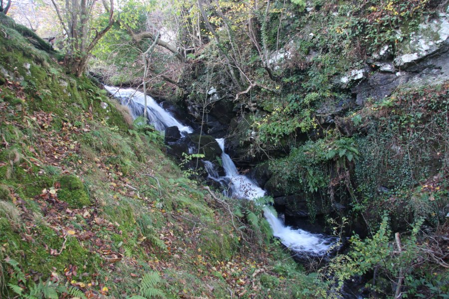
On the other bank of the river, continue to follow the edge of the fields, heading back down the valley. This soon gains a more substantial track which continues in the same direction. When the path splits, with the track ahead reaching a gateway, take the path that branches off up to the right, climbing up to the edges of some higher fields. This soon reaches the Nant Achlas stream. A stile on the left appears to be a concessionary path over private land. (If not, the legal access route is to ford the stream, and then follow the far bank downstream to the end of the bridge.) Follow the concessionary path along the right edge of the field, near to the stream, to locate and cross another stile, reaching the end of a new footbridge over the stream. Pistyll Cablyd is under the bridge. Return using the same route.
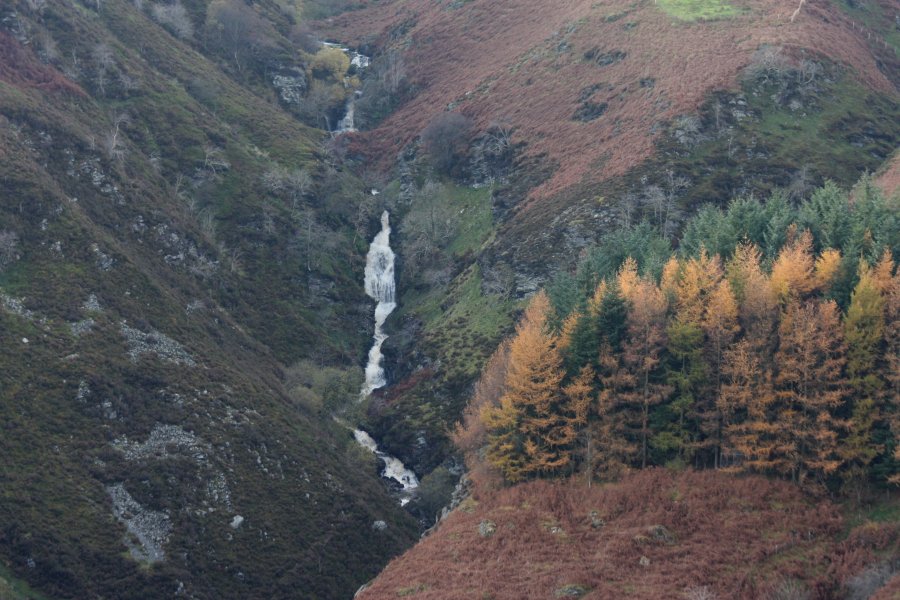
From the church, return down the lane (towards Llangynog). After crossing the first bridge, an optional path heads up to a farm, where a continuing path on the left reaches the edge of the forestry - from there, it skirts a large buttress before eventually descending back to the road after 1 km. However, this path is poorly maintained, and it is easier to remain with the road, taking a right at the first junction, and another right at the second junction, to reach the same point. Follow the road up into the side valley as it becomes a dirt track, slowly climbing past a working farm and a derelict farm. As it reaches the head of the valley, a waterfall can be heard through the forestry. This is Pistyll y Gyfyng, but is badly obscured by trees and some crags. The only way to get a proper view is to very carefully descend a scree slope about 100 metres before the waterfall, or the steeply sloping land closer to the waterfall, and view it from below. (Even then, trees will partially block the view, especially in summer, and some parts will not be visible without climbing up the waterfall itself - climbing the waterfall is not recommended or graded.)
Immediately above the waterfall, the track splits. Take the right branch, which zigzags to gain height before breaking out into the open. Follow the track ahead at a crossroads and right at a fork, to reach the Llyn y Mynydd reservoir. Continue past the reservoir, and when the track begins to die out, make your way ahead-right up to the summit of Trum y Fawnog, at the edge of the forestry. On the far side, beyond a fence, is the Nant Achlas valley. Cross the fence and follow the edge of the forestry down the edge of the valley, until the open access land ends at a fence. Follow the fence to the left, remaining at the edge of the open access land until you can locate and follow a path zigzagging slowly down into the valley below. Once near the stream level, follow the path over a stile to the remains of a wall and a new footbridge over the stream. Pistyll Cablyd is under the bridge.
On the other side of the bridge, there is a stile to the left, which appears be a concessionary path over private land. (If not, the legal route is to return over the previous stile, then ford the stream to pick up the path running outside the edge of the fields.) Follow the concessionary path along the left edge of the field, near to the stream, to locate and cross another stile back into open access land, at the upstream end of the field. Turn right and follow the field edge until the path swings into the main valley, slowly descending to the edge of some lower fields. Continue along the edge of the fields until they end at a ford in the river, under the shadow of the immense Pistyll Blaen-y-cwm.
Locate the path returning back along the valley at the top edge of the fields on the far bank. Follow it until it joins the main path. Take the path ahead-right, descending through a gateway into a field. Descend diagonally across the the field to a gateway into the next field at the far corner, then follow the treeline down to a gateway onto the lane. Turn left, and follow the lane back to the church.
From the lay-by, take the track towards the stream. Either cross the stream then head down the bank of the next stream without a path, or take a track that branches left early on, and hope you can get a good enough view from that.
| Waterfall | Grid reference | GPS coordinates | Image |
|---|---|---|---|
| Pistyll Blaen-y-cwm | SJ 00746 27641 | 52.837109°N, 3.474870°W | |
| Pistyll Cablyd | SJ 01461 26680 | 52.828604°N, 3.463969°W | |
| Pistyll y Gyfyng | SJ 02114 24587 | 52.809915°N, 3.453653°W | |
| Afon Eirth Falls | SJ 01826 29603 | 52.854939°N, 3.459435°W | |
Whilst every care has been taken in the compilation of this description, neither the author nor his fellow walkers can accept responsibility for loss or injury arising from any errors, omissions or inaccuracies in this description. This description is intended as a guide only, and you should select a route to suit your own abilities, at your own discretion. Ability requirements are a guide only. Route maps are approximated. You follow this description at your own risk.