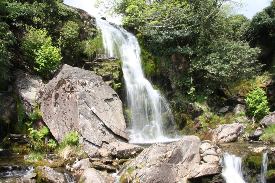
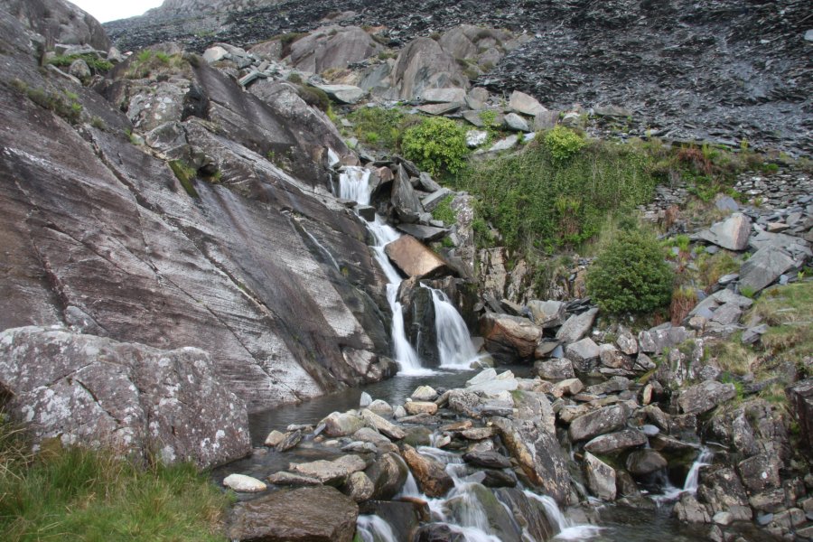
Including Cwmorthin Falls and Rhaeadr Tan-y-grisiau.
From Cardiff, take the A470 to the roundabout in Blaenau Ffestiniog. From Blaenau Ffestiniog, take the first turnoff (left) onto the A496, signposted to Porthmadog. After 1 mile, turn right onto a road signposted to the Tanygrisiau heritage railway station, then immediately turn left. Pass the parking area for the railway station, and park in the next parking area on the right, beside a picnic area and visitor centre, overlooking the Tanygrisiau Reservoir. SH 6813 4493.
Walk back along the road towards the railway station, almost immediately crossing a bridge. Look up to the left to see Cwmorthin Falls on the far side of the railway line. (Experienced river walkers may choose to hop off the far end of the bridge and head upstream, passing under the railway bridge to get closer to the waterfall, then return to the road. See the note about railway-owned land below.) Continue past the bridge and take a track to the left up to the railway line. After making the usual railway crossing safety checks, cross the railway and pass between the houses to a path on the other side. Follow it to the right, slowly heading uphill to approach some houses on the far side. When near to a line of terraced houses, head left to pass a tiny reservoir, then turn right to pick up the end of a small lane. Follow it to a more substantial road and turn left.
Where the road turns left, continue ahead on a narrow lane and follow it up past a large slate tip to a parking area. If you would like to see the extra waterfalls, continue up the track for 200 metres - before the first side track leads off on the left - then return to the car park. At the upper end of the parking area, a path leads off to the left of the track. Follow it to the river crossing to see Rhaeadr Tan-y-grisiau on the right. Continue to reach a road. Choose either the short route or the extended route. Note that I have not followed the extended route, and its grading is therefore assumed but not confirmed.
The short route is to turn left on the lane, and follow it to a junction with the main village road. Turn right and follow the road over a level crossing, where there is a rather poor waterfall hiding up to the right above the railway line. The road then curves around to the left to reach the start of the walk.
The extended route is to turn right on the lane, and follow it for 2.5 km to the Llyn Stwlan reservoir. The lane climbs steadily along the flanks of Moel-yr-hydd, turning a few hairpins before the dam comes into view, and a path on the left crosses the stream to some ruins. Continue up the lane as it turns a series of dramatic hairpin bends, to a fork below the dam. Take the right fork to reach the reservoir, and the impressive view of Moelwyn Bach, Craigysgafn and Moelwyn Mawr. Return down the dramatic hairpins to the path to the ruins. Follow the path, past the ruins, to the obvious remains of a railway inclins on the other side. Turn left to follow the incline downhill.
The incline alternates from gentle to steep slopes, heading towards the Ffestiniog Power Station and Tanygrisiau Reservoir. The taller stone walls on either side at the top of the steep sections are the remains of stone drumhouses (the first one has only one wall still standing, subsequent ones have both walls). At the right bend just before the fourth drumhouse, take a path on the left, crossing a stream and passing a rocky outcrop to reach a modern fenced enclosure. Skirt the right side of the enclosure to reach its access lane. Follow the lane, crossing the Ffestiniog Railway at a level crossing, to reach a junction with the main village road, where there is a rather poor waterfall hiding up to the left above the railway line. Turn right and follow the road around a bend to the left, to reach the start of the walk.
A note about the land owned by the Ffestiniog Railway; It is a criminal offence to trespass on public railway land. The Ffestiniog Railway is privately owned, and the British Transport Police therefore do not enforce the trespass law there. The owners of the Ffestiniog Railway are therefore responsible for deciding whether or not a person should be allowed to access the land owned by their railway. I have contacted the owners of the Ffestiniog Railway in September 2015, to check that they would not mind if people were to pass beneath the railway bridge at Cwmorthin Falls. Visitors must not walk over or interfere with the railway embankments or the railway itself, and would only be allowed to use the natural streamway as the access route. Both the upstream and downstream side of the bridge are designated CRoW land (one of the downstream banks is shown as a right of way instead), according to Ordnance Survey maps, so access is permitted. Seek advice from the owners as needed.
| Waterfall | Grid reference | GPS coordinates | Image |
|---|---|---|---|
| Cwmorthin Falls | SH 68201 44997 | 52.986052°N, 3.964777°W | |
| Rhaeadr Tan-y-grisiau | SH 68242 45497 | 52.990554°N, 3.964371°W | |
Whilst every care has been taken in the compilation of this description, neither the author nor his fellow walkers can accept responsibility for loss or injury arising from any errors, omissions or inaccuracies in this description. This description is intended as a guide only, and you should select a route to suit your own abilities, at your own discretion. Ability requirements are a guide only. Route maps are approximated. You follow this description at your own risk.