Including Grey Mare's Tail and Fairy Falls.
From Cardiff, take the A470 to Llanrwst. From Llanrwst, turn left onto the B5106, signposted to Trefriw. (The road crosses the narrow bridge in Llanrwst, then later turns right at a junction, and 300 yards later it passes the entrance to the Grey Mare's Tail site on the left - a gateway just after a house. SH 7911 6114.) In Trevriw, turn right in front of the woollen mills, signposted to the parking area. Park in the parking area on the right. SH 7816 6302.
Although this entire route is on roads or well maintained paths, it is quite long - about 7.3 km. It also requires at least one section of walking along the verge of a busy road. As such, it may not be suitable for beginners. However, beginners may wish to visit the waterfalls separately, driving between them. (From the Trefriw parking area, the Fairy Falls can be reached without needing to follow the rest of the walk; walk back up to the woollen mills, turn right to cross the river, take the next left, then follow a pathway on the left to the waterfalls.)
For the full walk, from the Llanrwst parking area, head along the lane, away from the village. A pavement appears on the left as the lane runs beside a playground. Use the pavement, which then swings left onto a path running parallel to the lane. Turn right on the path to continue parallel to the lane. Rejoin the lane when the path ends. Eventually, this crosses a footbridge over the River Conwy. Cross the bridge then turn right to gain a riverside path. (If the river is in flood, the path can disappear underwater. In flood conditions, continue ahead to Llanrwst, turn right at the end of the lane, then right at the end of that road onto the A470. Follow the A470 through the town square to reach the Conwy bridge.) Follow the path upstream along the river, taking the right branch at each junction to remain by the river, until the path rejoins the road just before the very obvious and characteristic stone bridge over the River Conwy. Turn right onto the road, then turn right to walk over the bridge on the very narrow pavements.
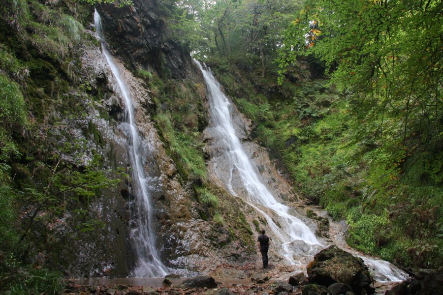
Follow the road (there's a pavement on the left) until it reaches a junction at the first bend to the right, where the pavement no longer follows the main road. From here, it's best to cross the road and walk on the verge on the right side. Continue another 300 metres along the same road, to a house on the left. Just after the house, go through the gate on the left. Follow the path that begins to the right of a parking area, up the side of the stream and past a weir, to reach the Gey Mare's Tail twin waterfalls. Take the path to the right of the waterfalls, which zigzags to the top. At the top, there is a stile onto a lane.
Turn right on the lane, keeping left when it splits early on. (It would be possible to take the right fork to descend to the main road, then later a track on the left to climb back up to Trefriw, but this misses out on the views.) The road climbs up with occasional views across the beautiful Conwy valley, then passes a pretty little lake. It reaches the tiny village of Llanrhychwyn after about 1.5 km. Turn right at the crossroads in the village, and follow the road steeply down into Trefriw. (There is also a footpath reached by continuing ahead from Llanrhychwyn for two fields, which could be used to bypass some of the road, but I have not followed it.)
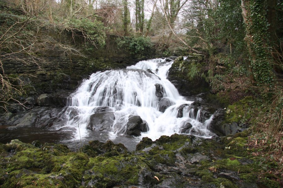
Immediately before crossing a bridge over the river in Trefriw, take a quick detour to the left, and then look through a gate on the right to see the dam of the reservoir that supplies the river. Now return to, and cross, the bridge (looking upstream to see the dam again). Turn right after the bridge, and follow the lane down until you reach a pathway down on the right. Take the path, then take the right fork before a footbridge, and follow the path down to the Fairy Falls. From there, head downstream on the river bank to see the lower falls, eventually emerging on another road. Turn right and follow it to the next junction, then turn right again to reach the woollen mills. The parking area and start of the walk are down the road opposite the mills.
| Waterfall | Grid reference | GPS coordinates | Image |
|---|---|---|---|
| Grey Mare's Tail/Rhaeadr y Parc Mawr | SH 78965 61044 | 53.132769°N, 3.810561°W | |
| Fairy Falls/Rhaeadr y Tylwyth Teg | SH 77879 63039 | 53.150445°N, 3.827545°W | |
Whilst every care has been taken in the compilation of this description, neither the author nor his fellow walkers can accept responsibility for loss or injury arising from any errors, omissions or inaccuracies in this description. This description is intended as a guide only, and you should select a route to suit your own abilities, at your own discretion. Ability requirements are a guide only. Route maps are approximated. You follow this description at your own risk.