
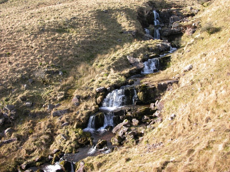
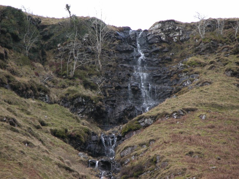
Including Nant y Llyn, Nant Tawe Fechan Falls and Joe's Waterfall.
From Cardiff, take the A470 to the end of Merthyr Tydfil. From Merthyr Tydfil, take the A465 to the left towards Hirwaun, follow it over the hill, and down to the next roundabout. Take the second turnoff, remaining on the A465, to the next roundabout. Take the second turnoff onto the A465 dual carriageway. Take the first exit off the road after about 4.5 miles, onto the A4109. Follow the A4109 (which becomes the A4221 on the plateau) to the end of the road at Abercraf. Turn right onto the A4067. Follow it past Glyntawe, to the Tafarn-y-Garreg pub. For the shorter route, park in the pub's parking area. SN 8488 1712. For the longer route, turn left just after the pub, signposted to Trecastle. After 2 km, it passes over a cattle grid, and becomes unfenced on one side. As it continues along the valley, it passes over some small bridges with stone walls. Just after the fourth of these are the parking areas on the left, and Nant y Llyn is also clearly visible up to the left. SN 8531 2033.
From the pub parking area, take the Beacons Way footpath that crosses a footbridge over the river. It skirts the Ty Henry farm before breaking into open access land. Ahead, a path continues beyond some enclosures up the ridge of Fan Hir. Follow this up onto the ridge, and continue along the ridge for over 4 km, until it drops to the pass between Fan Hir and Fan Brycheiniog. Pick up the path that drops down from the pass to the Llyn y Fan Fawr lake.
Just before the lake, a poorly defined path heads along the bottom of Fan Hir's scarp to the right, picking up the path running along the top of a large moraine. When it reaches the Tawe Fechan stream, the path crosses the stream and continues above it. When the stream starts to cut a small valley, you may need to leave the path to see the Nant Tawe Fechan Falls on the stream. Follow the path onwards, remaining above the stream and some field walls that surround it, passing several waterfalls that tumble off the scarp - the largest of these has Joe's Waterfall at its top. Continue onwards to reach Ty Henry, then return to the parking area to complete the route.
From the parking area, drop down to the Afon Tawe (which has a few visible cascades) and ford it to pick up the path running up the far side, to the right of the Nant y Llyn gully. Follow it all the way up past many waterfalls to reach the Llyn y Fan Fawr lake, keeping an eye out for the Maen Mawr stone circle to the right early on. (At this point, many walkers return the way they came.)
Just after the lake, a poorly defined path heads along the bottom of Fan Hir's scarp to the left, picking up the path running along the top of a large moraine. When it reaches the Tawe Fechan stream, the path crosses the stream and continues above it. When the stream starts to cut a small valley, you may need to leave the path to see the Nant Tawe Fechan Falls on the stream. Follow the path onwards, remaining above the stream and some field walls that surround it, passing several waterfalls that tumble off the scarp - the largest of these has Joe's Waterfall at its top. Continue onwards to reach Ty Henry at a series of small walled enclosures just before a farmhouse. (At this point, if you have bitten off more than you can chew, or if the weather is too bad to walk the ridge, you can take a path to the left that skirts the farm and crosses the river, to arrive at the pub parking area. Turn left and immediately left again, and follow the lane for 3 km back to the car.)
From Ty Henry, take the path that heads to the right at the enclosures, up the ridge of Fan Hir. Follow this up onto the ridge, and continue along the ridge for over 4 km, until it drops to the pass between Fan Hir and Fan Brycheiniog. Pick up the path that drops down from the pass to the Llyn y Fan Fawr lake. From there, pick up the Nant y Llyn path and descend back to the start of the walk.
| Waterfall | Grid reference | GPS coordinates | Image |
|---|---|---|---|
| Nant y Llyn | SN 84826 20522 | 51.871343°N, 3.674307°W | |
| Nant Tawe Fechan Falls | SN 84237 18777 | 51.855538°N, 3.682272°W | |
| Joe's Waterfall | SN 84231 18064 | 51.849129°N, 3.682120°W | |
Whilst every care has been taken in the compilation of this description, neither the author nor his fellow walkers can accept responsibility for loss or injury arising from any errors, omissions or inaccuracies in this description. This description is intended as a guide only, and you should select a route to suit your own abilities, at your own discretion. Ability requirements are a guide only. Route maps are approximated. You follow this description at your own risk.