Including Pistyll Gwyn - Nant y Pistyll-gwyn.
From Cardiff, take the A470 to Llan Ffestiniog. From Llan Ffestiniog, immediately before passing under the railway bridge at the start of the village, turn right onto the B4391, signposted to Bala. After passing the deep Cwm Cynfal valley, turn left onto the B4407, signposted to Ysbyty Ifan. A small lake - Llyn Dubach - soon appears on the left, and there is a parking area along a track on the left immediately before it. SH 7461 4237. (If you are only planning on visiting the waterfall, you may as well continue along the road until it crosses a stream, then find a verge to park on. The waterfall lies just upstream.)
Warning; this area is littered with old mines, some of which are fenced off, some of which are not. You should avoid entering these without specific experience of mine exploration, and avoid accidentally straying into them. In addition, this area is devoid of paths. It has some rights of way, but the ground is invariably boggy, and quickly swallows paths. Much of the walking will be over bog without paths, and the ability to navigate in that terrain is essential. A compass is required for this route.
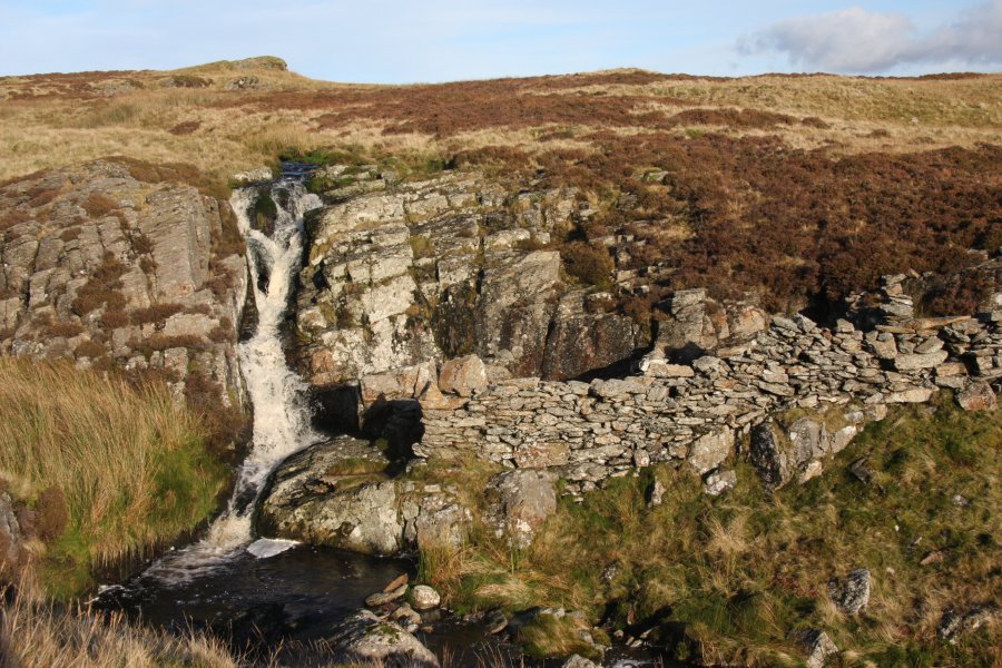
Walk back out of the parking area onto the road and turn left. Follow the road until it crosses a stream after 600 metres. The waterfall lies upstream, and the top of its outcrop can be seen from the road. Just after the stream, head across the bog to the Pistyll Gwyn waterfall, and the small sheepfolds around it.
Now for Y Garnedd. Cross the stream and face towards the waterfall, so that it pours directly towards you. Back over your left shoulder is a rocky outcrop, on a bearing of about 290°. Head up that rocky outcrop, and from there continue along the little rocky ridge towards its high point at Y Garnedd. As you walk along it, note the smaller rocky outcrop ridge of Carreg y Foel-gron on your left (the area between that and your ridge is very boggy). At the pass between Carreg y Foel-gron and Y Garnedd is a track with the Foel-gron Quarries on the right. Once you have touched top at Y Garnedd, head back the same way until you have passed the quarries (make sure you come back far enough), then head down to the pass to pick up that track.
Follow the track past the quarries until just before it swings hard left. Descend to the bottom of the slope on your right where appropriate, and begin heading towards the right side of the large Llyn Morwynion reservoir, initially heading a little too far to the right, then swinging back towards its right side. Walk almost all the way around the lake, crossing the dam at the far end, and returning down the other side. Just after crossing the stream flowing into that corner, aim back towards Llyn Dubach, which cannot be seen from here. Use a compass bearing of 90° - there is a track heading the right way, but it may have been lost in the boggy ground between the lakes. It aims too far to the left at first, along the line of a drainage channel, to skirt a rise in the terrain, before turning right towards the smaller lake. On the right side of the lake is the parking area from the start of the walk.
| Waterfall | Grid reference | GPS coordinates | Image |
|---|---|---|---|
| Pistyll Gwyn | SH 75070 42987 | 52.969640°N, 3.861738°W | |
Whilst every care has been taken in the compilation of this description, neither the author nor his fellow walkers can accept responsibility for loss or injury arising from any errors, omissions or inaccuracies in this description. This description is intended as a guide only, and you should select a route to suit your own abilities, at your own discretion. Ability requirements are a guide only. Route maps are approximated. You follow this description at your own risk.