Including the wonderfully secluded Llech Sychryd.
From Cardiff, take the A470 past Merthyr Tydfil, and continue along the A470 towards Brecon. 2.3 miles after the A465 junction, in the village of Llwyn-onn, take a small lane to the left, signposted to Cwm Cadlan. Follow the lane over the dam of the Llwyn-onn Reservoir, and turn right at the far side. After another 0.6 miles, turn left onto a lane signposted to Cwm Cadlan, which climbs steeply up, eventually crossing a cattle grid into open countryside. After 0.4 miles, there is a small parking area on the right, and more on the roadside to the left. SN 9849 1103.
There used to be a much shorter access route described here (under 2 km), but the upgrade to the A465 has now made it impossible. While it would theoretically be possible to start at the nearby Jah-Jireh Charity Homes (for Jehovah's Witnesses) site, that would involve walking through a private forest containing the Dynevor Arms LNG Storage facility, and the forest tracks are heavily overgrown and nearly impossible to fight through. It would take nearly the same distance to get to a useful exit point from the forest as it does using the route described here, and it has no official access permission while passing the gates of a Critical National Infrastructure site lined with video cameras. Another potential route from the nearby Nant-moel Reservoir would require crossing through private property owned by the Aberdare and District Angling Association, and then crossing barbed wire fences to get into the open access land. All of these potential routes require coping with very demanding ground.
As a result, this new route (from 2025) avoids the permission problems altogether. It is entirely based on open access land, and takes in some impressive views on the way. However, it has to cross a wider moorland, without a proper path (this is the case for all possible access routes). It is quite long, and for parts of the route, it crosses boggy ground (even in summer drought), so tall waterproof footwear, such as wellington boots, is essential. The ground can be quite demanding in a couple of places, with tall tussocks that try to twist ankles. Approach the walk with a good sense of humour, and use walking poles to aid balance or check the depth of marshy patches. Good visibility is needed, since the navigation relies on landmarks some distance away, but a significant amount of water helps to make the waterfall more interesting. A GPS is strongly encouraged, but bearings are given here in case they are preferred.
From the parking area, there are two large shakehole features in the the shallow depression to the South. The one to the right has a shallow lake at the bottom, while the one to the left is actually several shakeholes, with the low remains of an enormous cairn, basically now a large patch of rocks. Follow the path towards the remains of the cairn (a bearing of about 140°), and pass its left side to where the path splits on the other side. Take the right branch, to reach the right shoulder of the ridge ahead (Cefn Sychbant), on a bearing of 143°.
Once on the ridge, a forest can be seen on the far side of a valley 1.3 km ahead. The forest will be used for navigation from here onwards. The point you are aiming for is its right corner. While there are several hints of path running through the boggy marsh just ahead, none of them head in useful directions for long, so you simply have to aim for the right of the forest, and try to keep that direction if you lose sight of it. The actual bearing you are aiming for is 180°, but at the moment, you will not actually see the right corner itself, and so you will walk on a bearing of about 170° for now. After crossing the marshy patch, the view into the Cwm Cadlan valley opens out, and the right corner of the forest can be seen, with an enormous stream sink just in front of it.
The route to the stream has to pass through a large bracken patch, and although it is initially easier to skirt it to the left, at some point it becomes necessary to wade through it, and aim for the forest corner again, now on a bearing of about 200°. A few marshy patches, and very tall tussocks need to be argued with on the way. It is best to aim for the stream, Nant Cadlan, a little to the left of the sink, and pick up a path that runs along the top edge, so you can enjoy the view. This part of Cwm Cadlan is called Pant Sychbant (hollow of the dry hollow). The sink is Ogof Fawr (big cave), one of the most significant caves in the valley, though it is not part of this walking route. The walking route turns right on the path and stays with it as it curves away from the sink to cross a surprisingly deep stream gulley, but from that point, the path is quite useless. After crossing the little stream, head to the left and skirt the right edge of the Ogof Fawr sink, taking care to avoid the cliff. Continue around to reach the corner of the forestry fence.
From here, the route follows the fence line heading away from the stream, passing over a decaying gate after 180 metres to remain on the right side of the forestry fence, now picking up the remains of a path. The hill to the right is Mynydd-y-glog (mountain of the cloak), while the forested hill on the left is Onllwyn (ash tree grove) and the poorly named Penmoelallt (head of the bald slopes), neither of which are right. (It should be noted here that the Ordnance Survey map approximates the position of the fence incorrectly, so the mapped path sometimes appears to be on the wrong side of it.) After the fence turns a significant corner to the right (where there is a crossable fence leading into the forest, if you want to torture yourself with it), the path repeatedly heads a short distance away from the fence to pass small shakeholes. Just after passing a stile on the left, the path heads a long way from the fence, to avoid a large shakehole with a cliff below the fence. From here onwards, the path remains about 70-100 metres from the fence. It passes a path heading pointlessly to the left into the nightmare of a forest, then climbs up the right bank of a shallow valley ahead. The waterall is at the far end of the valley, but this end is far too marshy and tough to make progress.
Stay with the path as it runs along the top of the valley side, usually a little way from it, to avoid the bracken. After 250 metres, it reaches a fence coming out of the valley, and turns hard right to follow it in the wrong direction. A few metres away from the valley, the barbed wire has been removed from the fence, making it possible to cross it. Cross the fence, to continue along the valley top. After another 375 metres, the path reaches the corner of a fenced enclosure which is not shown on the maps, and the path divides. (The path to the right could be followed to where animals had broken through the fence, to bypass the descent into the valley until later, but it's a very pretty valley and deserves the attention.) The path to the left is the way on. Follow the fence half way towards the valley, then branch off ahead-left, and locate the remains of a path heading down into the valley just above some trees. Follow it down to the right, descending steeply to the valley bottom.
On the opposite bank, just a few metres upstream, a smaller stream joins from a side valley. It has its own small waterfall, which is awkward to reach, and can only be visited in winter when the undergrowth has died back. On the left side of the smaller stream, cross the fence into the forestry, and ascend the left bank of the stream, remaining above the stream's gully. The waterfall can soon be heard in the gully. Descend to it when appropriate. Return to the main little valley.
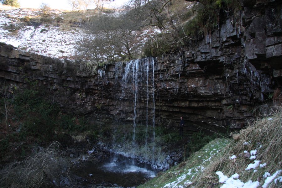
From the point where you first reached the stream in the little valley, follow it downstream, typically staying on the right bank where there might be the remains of a cattle path. It may be marshy in some places. After nearly 300 metres, the path rises up to the remains of three stone enclosures. Stay on the left side of the first two, and the right side of the third, to reach a large sloping slab; the llech of Llech Sychryd. The waterfall lies below the end of it, where the valley cuts much deeper.
At the edge of the waterfall, decide which side to descend. The right side has a cliff with some very difficult rocks and undergrowth below it, but it might be possible to descend that side in winter. However, the more significant path is to cross the stream just upstream of the waterfall (the rhyd of Llech Sychryd). In summer, this can be nearly dry (the sych of Llech Sychryd), but great care will be needed in winter floods. The path then passes along the top of the cliff, and great care must be taken. At the end of the cliff, turn right onto a path heading down to the right, to the bottom of the Llech Sychryd waterfall. Take a picnic and enjoy it in the ample space behind the waterfall. The return route is the same (the forest is not worth a diversion).
| Waterfall | Grid reference | GPS coordinates | Image |
|---|---|---|---|
| Llech Sychryd | SN 99129 07278 | 51.755078°N, 3.462774°W | |
Whilst every care has been taken in the compilation of this description, neither the author nor his fellow walkers can accept responsibility for loss or injury arising from any errors, omissions or inaccuracies in this description. This description is intended as a guide only, and you should select a route to suit your own abilities, at your own discretion. Ability requirements are a guide only. Route maps are approximated. You follow this description at your own risk.