Including Pwll Annie and Cyfarthfa Pwll Glas.
From Cardiff, take the A470 to Merthyr Tydfil. Take the A4102 to the right, past one more roundabout, and turn left at the traffic lights, onto the A4054. Turn left at the mini roundabout in front of the Cyfarthfa Castle gates. Continue past the next mini-roundabout, then immediately after a pedestrian crossing and immediately before The Lord Raglan pub, turn left at a crossroads into Old Chapel Road. Stay with it as it swings right and passes under the Cefn Coed Viaduct. Park on the roadside just after it crosses the Taff river. SO 0294 0773.
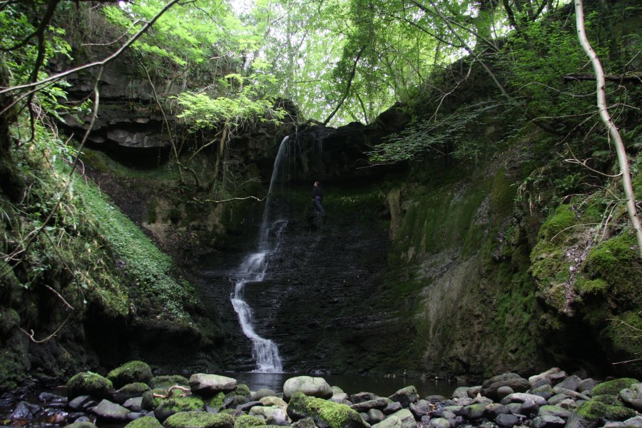
The main Pwll Annie waterfall is now accessible from a service track for the A465 bridges, but reaching it requires crossing a single private field. Request permission accordingly. The view is obscured during summer, and visits are best made in winter, when there are no leaves blocking the view. The lower waterfall and Cyfarthfa Pwll Glas can be accessed with comparatively little difficulty, though care must still be taken in the gorge. Waterproof footwear is required for crossing the stream.
From the parkng spot under the Cefn Coed Viaduct, head away from the bridge that crosses the river. The road splits immediately. To the right is the way to the Pwll Annie main waterfall. To the left is the way to the lower Pwll Annie waterfall and Cyfarthfa Pwll Glas, which has boulders blocking the track.
For the Pwll Annie main waterfall, take the right branch, which climbs fairly steeply and turns right, then passes beneath the impressive A465 flyovers. It soon reaches the gates of the Ffrwd Cemetery on either side. Continue ahead onto a track with a barrier, and stay with it as it turns into a path, passing more entrances into the cemetery gardens. The path runs beside the A470, then descends to pass under a bridge below it. Here, it turns hard left, returning back up the other side of the A470. At the top of a slope, it reaches a gate at a junction of paths and a road. The way on is ahead, along a farm lane, ignoring the junction with the A470 to the left. The lane soon passes a farm (you should ask for permission from the landowner), then runs between fences. After climbing up to a view over Merthyr Tydfil, it crosses a cattle grid, and opens out into a field without a fence. The fields here can have free-roaming cattle, and are not suitable for dogs. At this point, the route is to follow the left side of the field to the left, avoiding some trees, then following the fence line down past a pylon to the bottom of the field, next to the A465. At the bottom is a gateway leading to a service track running below the A465 bridge. After passing under a slip road bridge, the track passes under the major bridge of the A465 itself. The waterfall is to the right, and can be seen through the trees in winter. It is very steep down below, with crags and rubble slopes, and the final few metres are vertical at all points. As a result, this route guide does not offer any suggestions for how to get a better view. Return using the same route to where the route split at the start of the walk.
For the lower Pwll Annie waterfall and Cyfarthfa Pwll Glas, taking the left track at the split. It soon turns hard left and crosses a stream (the route directly upstream is now fenced off, but the samne place can be accessed using the following directions). Continue on the main path as it passes under the A470 bridge. Immediately afterwards, it bends left, passing the route to Cyfarthfa Pwll Glas on the left, and a small path doubling back on the right. Shortly after the bend left, take another small path heading ahead-right on the right side of the path, into a forest. It curves right and climbs to the top of the forest. Immediately after it opens out into an overgrown field, it turns to the right, then splits. Take a path to the right leading towards a pylon. This soon descends to a path junction in a patch of trees. Turn right to cross a small bridge. After the bridge, take the path to the right at a junction, and continue to the right, at the edge of the forested slopes. After passing the pylon then a small bench, the path turns left to follow a fence. Immediately to the right of the start of the fence is a smaller path descending onto the forest. Follow the descending path down to the stream. The way on is upstream (to the left), and occasionally has hints of a path, but it often requires walking in the stream, or crossing fallen trees, and waterproof footwear is required. After 400 metres, a smaller waterfall is passed on the left as the attractive gorge begins, passing under the A465 slip road bridge. The lower Pwll Annie waterfall is a short distance upstream, and is the highlight of this route, well worth the effort needed to reach it. Watch out for falling debris while in the gorge.
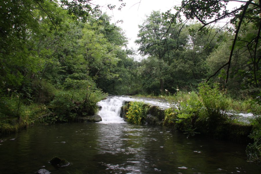
Return to the main track and turn back towards the A470 bridge and the parking spot. Immediately before it passes under the A470 bridge, take a small path to the right that also passes under the A470, and turn right at the far side to climb up to the Taff Trail which runs on top of the viaduct. Follow it ahead-right (away from the viaduct) for about 800 metres, to Pont y Cafnau - the World's oldest surviving iron railway bridge (1793) - which leads off on the left into the Cyfarthfa Industrial Estate. Follow the estate road to the left, and just as you reach the other end of the industrial estate, drop down the river bank on the left to see the Cyfarthfa Pwll Glas waterfall, which lies immediately upstream. The view may be obscured by leaves in summer.
For added interest, continue a short distance along the Taff Trail past Pont y Cafnau, to reach the Cyfarthfa Ironworks. Return using the same route.
| Waterfall | Grid reference | GPS coordinates | Image |
|---|---|---|---|
| Pwll Annie | SO 02430 07545 | 51.758063°N, 3.415041°W | |
| Cyfarthfa Pwll Glas | SO 03788 07357 | 51.756609°N, 3.395320°W | |
Whilst every care has been taken in the compilation of this description, neither the author nor his fellow walkers can accept responsibility for loss or injury arising from any errors, omissions or inaccuracies in this description. This description is intended as a guide only, and you should select a route to suit your own abilities, at your own discretion. Ability requirements are a guide only. Route maps are approximated. You follow this description at your own risk.