
Including The Polo Mint, Cwm Dyar Waterfalls, Button's Waterfall and Clydach Tributary Waterfalls. Something to do when water levels are too high for anywhere else.
From Cardiff, take the A470 to the end of Merthyr Tydfil. From Merthyr Tydfil, take the A465 towards Abergavenny, follow it to Brynmawr. From Brynmawr choose your start point:
For Llanelly Quarry or Clydach South continue down the Clydach Gorge. At the bottom take the first road to the right since Brynmawr. It swings left and climbs to a junction. For Llanelly Quarry, turn right, then left at a fork, and continue upwards until the road crosses a dismantled railway line, where you can park on either side on the railway line. SO 2216 1250. For Clydach South, continue upwards; ahead at the junction. Pass a small road on the right then turn right at a junction. The road climbs very steeply before levelling out just for a moment at a sharp right bend. On the left is a narrow lane, where you may be able to find somewhere to park. SO 2311 1272.
For the Cuckoo or Waunllapria, take the second turnoff from the roundabout at Brynmawr along the A467, then the first turnoff at the next roundabout onto the B4248. It climbs up onto the ridge. Just after a tight 'S' bend and the Racehorse pub on the left, it dips for a moment. For the Cuckoo, continue into Blaenavon. Turn left onto the B4246 when the road ends at a T-junction, and follow the road up to a viewpoint towards the Black Mountains. Take a left just as the road starts to descend. Follow this smaller road past the Lamb and Fox pub, staying with the road until it starts to descend, and a shallow valley develops on the left. One track branches off ahead-left at a fork, then another doubles back hard on the left a little after it. You want that second track. Find somewhere to park, and be warned that the tracks are in use by farm vehicles. Warning; do not continue further down the Cuckoo road - it has partly collapsed into a quarry! SO 2375 1223.
For Waunllapria, turn left in the dip just after the Racehorse. The road descends steeply, then levels out. Stay on the same level, eventually taking a side road ahead when the road swings left at the Jolly Colliers pub. Continue beyond a cattle grid until there is some space to park on the left, and one of the small waterfalls is on the right. SO 2289 1205.
This takes in a variety of smaller waterfalls in the Clydach Gorge. By its nature, there are many, many waterfalls in this area, and the walk is limited only by the availability of convenient routes around it. These waterfalls are all best kept for a winter's day when there has been several days of heavy rain beforehand, but the visibility is good to get the superb views of the surrounding mountains, which can be seen from various parts of the walk. The route sometimes leads through rough ground without proper paths, and for part of it, follows an exposed, deteriorating path down a quarry. It also suffers badly from undergrowth and leaf-cover in summer. If you are not capable of coping with this sort of terrain, do not follow this route. There are two good starting points, one near Llanelly Quarry with the longest climb near its start, and one at the Cuckoo with that same climb near its end. There are also two more possible start points at Clydach South and Waunllapria, but the former has limited public parking space, and the latter is in a location where car crime is more likely to be a problem. I would recommend the Llanelly Quarry start point.
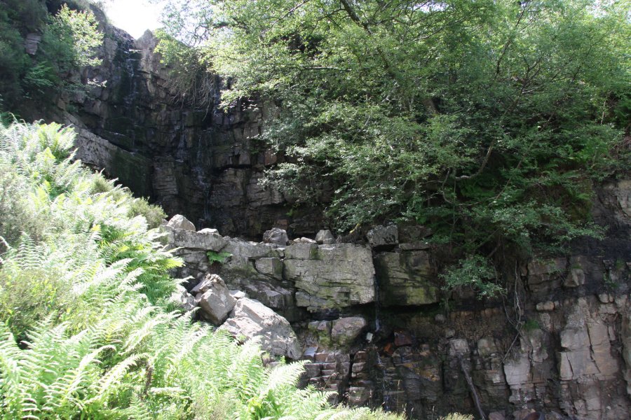
From Llanelly Quarry, follow the dismantled railway line (a cycle path) along the bottom of the quarry, past some lime kilns, to a short viaduct. On the right are two waterfalls, and below the viaduct are a series of cascades (a path to the left just before the viaduct leads to a nice viewpoint underneath it). In summer, the upper part is hidden by foliage, but at most times, the waterfalls run dry due to the water sinking into local cave systems - several days of heavy rain are needed to make the waterfalls flow properly. Continue along the railway line, taking the path around some tunnels, to the road at Clydach South. Cross the road into a lane on the other side.
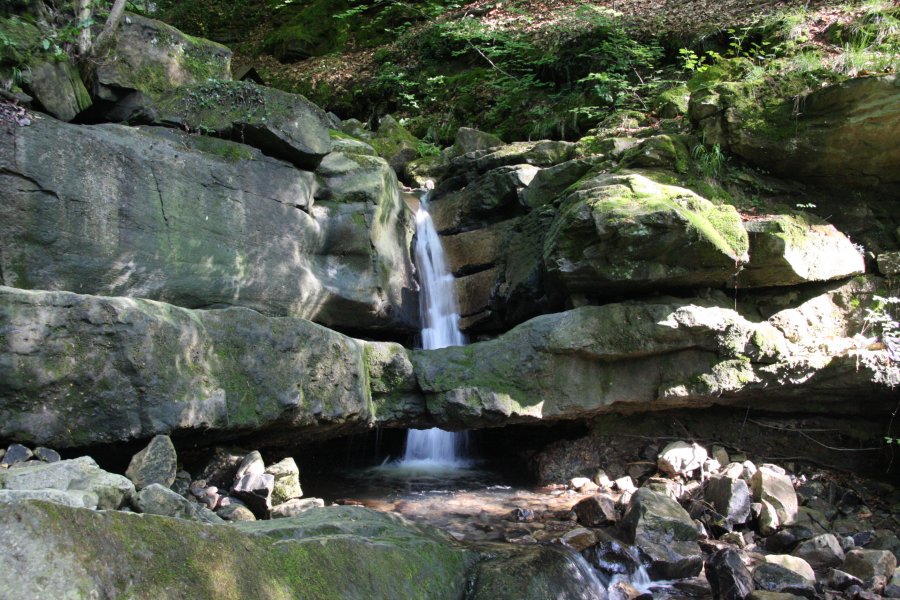
From Clydach South, continue along the lane which soon turns into a track, over a superb viaduct. At the other side, turn right into a limeworks, at the bottom of the Gilwern Quarry. A path down to the viaduct on the right gives somewhat awkward access to the stream flowing underneath, which plunges down a series of small waterfalls, the lowest of which flows through a hole in a natural rock bridge, and is known as The Polo Mint. These can only be properly seen from the stream bed, so be careful if the water levels are very high. Return to the quarry. Follow the bottom bench along a path, through a gateway. As the path doubles back, continue ahead to reach a cascading stream (Cwm Dyar) with a small cascading waterfall just upstream. Go back to the path and follow it up above the waterfall. Repeat this with the next waterfall, where the path then dies out. There is an official right of way some way up on the sloping left bank, but it is so badly overgrown that it barely exists. Continue up the valley, trying to remain above the sloping sides of the stream, but close enough to be able to see another waterfall, and many cascades. Eventually the Button's Waterfall is reached which is a relatively large double stepped waterfall, with the remains of at least one car at the bottom. Climb up the slope beside it to reach a track from the Cuckoo road. Turn right on the track.
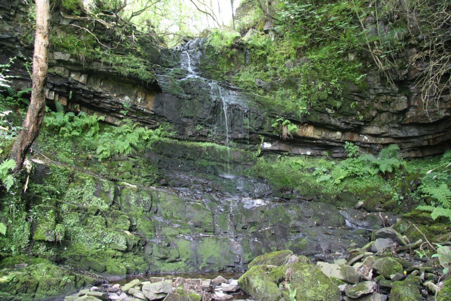
From the Cuckoo, the track quickly reaches the stream at the top of the Button's Waterfall (the name alluding to its previous owners), which has a lot of pollution. Make sure you are following the correct track (at the head of the waterfall, it passes through a gateway). Continue along it along what was once a tramroad, to reach some farms, and a waterfall on Nant Dyar-fach on the left, at Waunllapria. The waterfall is almost dry in summer, but can be a raging torrent in flood.
From Waunllapria, follow the road ahead (or back the way you came, if you started here) to a cattle grid. From here, there is a choice of shortcut and complete routes. The shortcut route is to turn right just beyond the cattle grid, down a small field and through a gate, and along a track. Turn left at the road, then right down another track. The track swings right, through a gate into an open area, to rejoin the complete route. Continue ahead-right. Skip the next two paragraphs.
The complete route continues ahead at the cattle grid, to reach a junction where a larger road joins from the right, and continues ahead, beside the Jolly Colliers pub. Take a narrow lane to the left beside the pub, and follow the road for about 600 metres until it joins another road (early on, a footpath to the left can be used to bypass a corner in the road, but it's heavily overgrown in summer). Double back to the right onto the main Llanelly Hill road. A minor road on the left passes over a waterfall in Cwm Llam-march as it turns a hairpin bend, but this is not visible from the road. There is also a small waterfall on the right along the main road, though in summer it just looks like a cliff. A little further along the main road, a footpath can be followed down to the left. This heads back up the valley, then swings right (downstream). Optionally, to see the previously hidden waterfall, continue ahead past the fence, then down to the stream bottom. Fight your way upstream through the undergrowth to reach the waterfall, then return to the path, and take the downstream direction.
After a way, take a path doubling back and sloping down to the left, to a road below, and follow it back towards the stream, to a hairpin bend where there is a waterfall on the left, and another directly under the bend (there is also another waterfall a little further downstream, but this is dangerous to get to - a cascade lower down can be seen on the Clydach Gorge main waterfalls walk). Return along the road, and follow the it until it joins another road which is turning (yet another) hairpin bend. Continue ahead-left, and take a road to the right almost immediately. Follow it as it turns into a path, and climbs up to a road. Follow the road along the top edge of Llanelly Quarry. When it reaches a stream, cross the stream using a footbridge (a small waterfall below the bridge is obscured, but not worth the effort needed to reach it). Continue through a gate along the left side of some private properties. Just past them, a larger track joins from the right, which is the shortcut joining.
Just afterwards, take an overgrown path doubling back to the left by some trees, which leads down a slope to the top of the quarry. In summer, the undergrowth is so bad that the path may be invisible. Follow the edge of the quarry (take care, the path has collapsed a little over the years I have known it), to reach the top of a (normally dry, except in flood) waterfall into a short artificial pothole, which is crossed using a knife-edge path which has suffered from a small landslide. Be very careful. On the other side, a slope leads down to the quarry floor. Follow the track through the quarry, to the remains of buildings and lime kilns on the right. Drop down into the buildings using a small path, and beyond them onto the dismantled railway. The Llanelly Quarry parking area is to the left (and if you parked in one of the other parking areas, the way on is to the right).
If you consider the quarry path too unsafe, when following the complete route, on the section of path just before the road that runs along the top of the quarry, take a path to the left, which takes you more gently down to the parking area. If taking the shortcut route, when reaching the road, continue uphill and take a small road to the right just after crossing a stream. Take a footpath on the right at the end of the road, and turn right just as it starts to level out. This is the same path that leads down to the parking area. Go along the railway to the lime kilns, and take a path up beside them. Follow the quarry track to the ramp up - the last waterfall can be seen at the top of that ramp.
| Waterfall | Grid reference | GPS coordinates | Image |
|---|---|---|---|
| The Polo Mint | SO 23195 12814 | 51.808665°N, 3.115426°W | |
| Cwm Dyar Waterfalls | SO 23222 12795 | 51.808498°N, 3.115030°W | |
| Button's Waterfall | SO 23665 12138 | 51.802653°N, 3.108461°W | |
| Clydach Tributary Waterfalls | SO 21931 11786 | 51.799249°N, 3.133524°W | |
Whilst every care has been taken in the compilation of this description, neither the author nor his fellow walkers can accept responsibility for loss or injury arising from any errors, omissions or inaccuracies in this description. This description is intended as a guide only, and you should select a route to suit your own abilities, at your own discretion. Ability requirements are a guide only. Route maps are approximated. You follow this description at your own risk.