
Including Sgwd Clun Gwyn, Sgwd Isaf Clun Gwyn, Sgwd y Pannwr, Sgwd yr Eira, Cilhepste Falls, The Sheep Dip and Ogof Tarddiant Hepste.
From Cardiff, take the A470 to the end of Merthyr Tydfil. From Merthyr Tydfil, take the A465 to the left towards Hirwaun, follow it over the hill, and down to the next roundabout. Take the second turnoff to the next roundabout. Take third turnoff, to reach Penderyn. From Penderyn, drive north through it along the A4059 until there are some lay-bys in an open area, usually with an ice-cream van in summer. Turn left along a road sign-posted to Ystradfellte. Follow it until the road forks - turn left. There is a signed "waterfalls" parking area in the forestry on the left, but it's best to take the next proper road on the left to the small pay & display Cwm Porth parking area in the bottom of the valley. SN 9280 1241.
This is one of the most celebrated of Welsh waterfall walks, and in my personal opinion is one of the best in the country. As one of the very few dedicated and named waterfall trails, it is one of the highlights of my lists. If you only have the opportunity to do one waterfall walk in the country, this route would be one of my first suggestions.
From the Cwm Porth parking area, there are two main routes to the waterfalls. The upper route starts 40 metres up the road from the parking area's entrance, but this is much more boring, although it may be preferred if the river is flooding. The lower route starts as two paths directly opposite the Cwm Porth parking area's entrance, and is the route that will be used for this walk.
(If you decide to use the upper route instead, follow the track for a considerable distance, until it ends near a house. Take the path on the right side of the house, continuing ahead-left when a path leads through a gateway on the right, to eventually reach a major path junction. Ahead is the forest loop route returning, and to the left is the way to the Gwaun Hepste parking area. To the right reaches the head of the first waterfall where the lower route joins from the right.)
On the opposite side of the road from the Cwm Porth parking area, the two paths of the lower route enter the woodland. Take the path on the left, which soon passes along a concrete walkway between some caves. Immediately after them, the path heads to the left to remain on the left edge of the woodland, with many more caves in fenced enclosures to the right. Eventually, the Mellte River appears in the valley to the right. Until this point, the river has been flowing beneath the path through the Porth yr Ogof cave system (whose massive entrance can be seen from a path leading down from the Cwm Porth parking area), and a path on the right leads over to the cave's resurgence. However, the edges of the resurgence are slippery, and the drop is quite far, so take great care.
The main path then descends and swings over to the river. Follow the river bank (quite a long way) to a bridge over the river - this bridge may be used to create a loop with the Elidir Trail, but is not part of this walk. Continue on the left bank of the river, to reach a junction of paths above the first waterfall; Sgwd Clun Gwyn. Down to the right is a zigzagging path down to the waterfall. Ahead is the start of the forest loop for this walk (which is also the end of the crag loop returning). The path to the left is the end of the forest loop (which is also where the upper route joins, and a route to the Gwaun Hepste parking area).
Choose either the forest loop or the crag loop, depending on your ability. Children may also be capable of following either route, depending on their abilities, but will need to be carefully supervised no matter which route is taken. (The national park promote the forest loop route, beginning in the Gwaun Hepste parking area.)
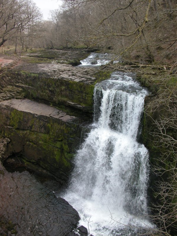
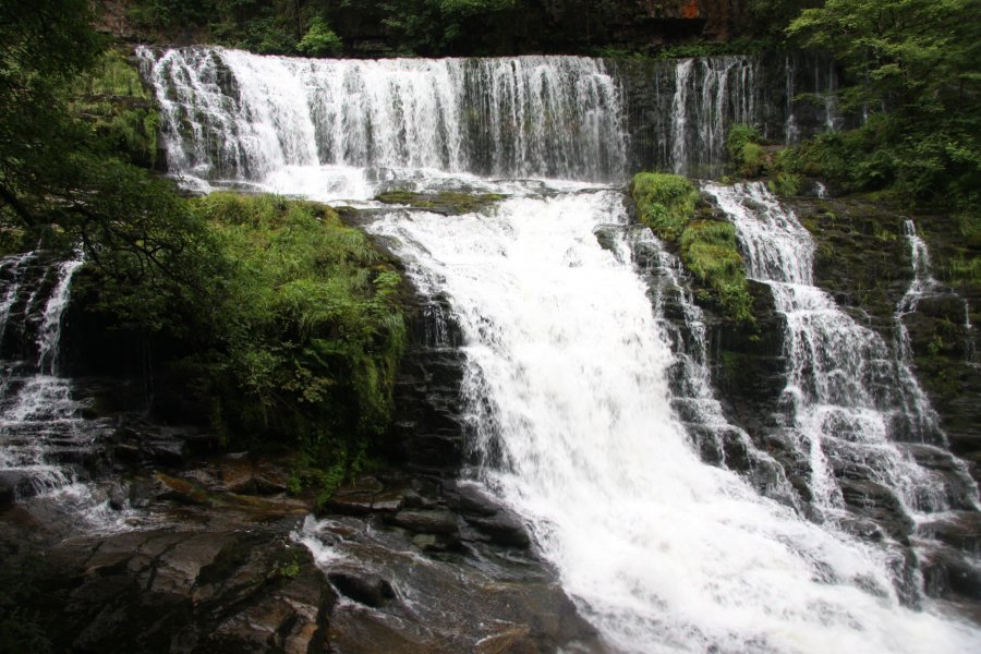
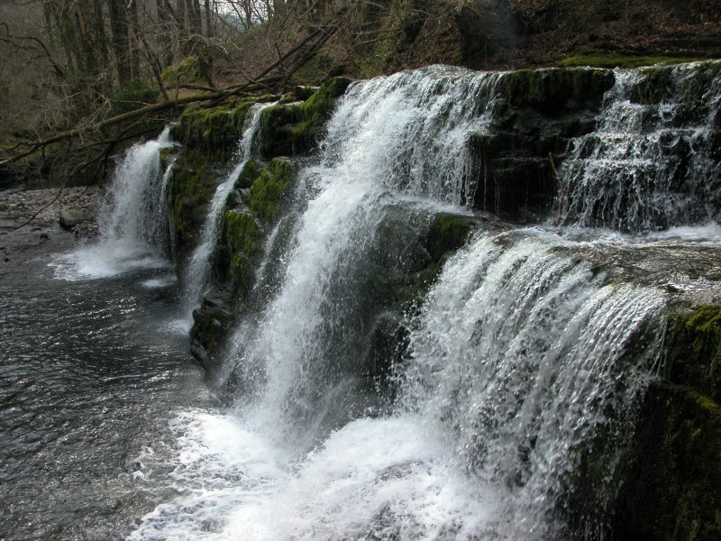
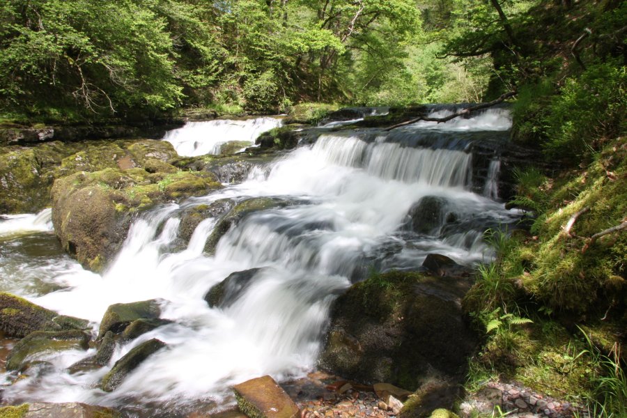
Head down the zigzagging path to view Sgwd Clun Gwyn. Then return to the path junction above the waterfall and turn right, following signs pointing to "Sgwd yr Eira". The path stays near the top edge of the gorge for about 1 km, until an obviously signed path doubles back on the right. Follow the path on the right all the way down to the river, where Sgwd y Pannwr is just downstream and Sgwd Isaf Clun Gwyn is just upstream (the rocky path climbing up to the right of Sgwd Isaf Clun Gwyn is the crag loop - the first part of this needs to be ascended slightly to see the spectacular upper benches of the waterfall).
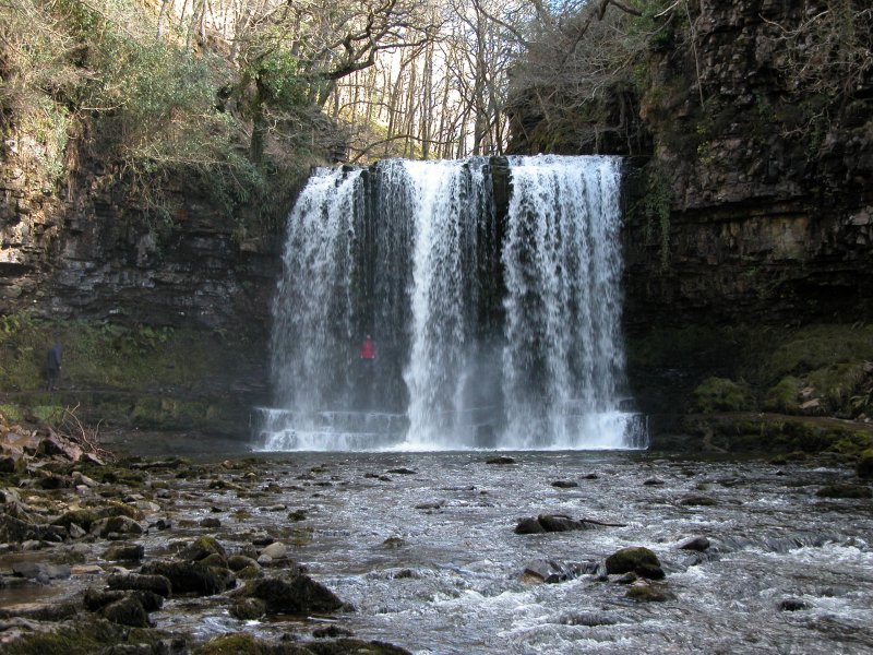
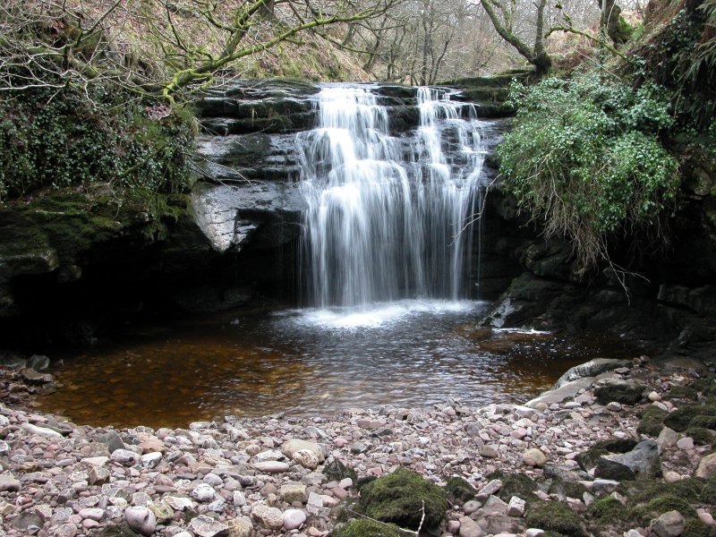
Return to the gorge-top path, turn right, and follow the path for 350 metres to reach the long set of zigzagging steps down to Sgwd yr Eira on the right. Descend the steps to reach the river, where Sgwd yr Eira is just upstream to the left. If your ability level allows it, you can walk behind Sgwd yr Eira in order to cross the Hepste River - it is famed for being the only waterfall in Wales with a public footpath running behind it, and is frequently visited for this reason (there are many others that can be walked behind, but none of those have official footpaths). Most visits end here. (The slippery riverbank to the right at the bottom of the steps is the crag loop returning - in theory this could be followed to see Cilhepste Falls, but that path requires additional abilities.)
Return to the top of the zigzagging steps, and turn right. The path soon swings left to head away from the river, and 150 metres further on, reaches a junction with a significant track. Turn left, and follow the track for 850 metres to another major track junction (the track to the right is the way to the Gwaun Hepste parking area, and the path ahead is the end of the boring upper route back to the Cwm Porth parking area). Turn left, and follow the track back to the junction above Sgwd Clun Gwyn. Turn right and follow the river bank path all the way back to the start of the walk.
Head down the zigzagging path to view Sgwd Clun Gwyn. Stay at the same height as the waterfall's viewing platform - about half way down the gorge, and follow the path downstream around a long bend in the river. It is quite exposed (early on, a signposted escape route on the left may be used to switch to the forest loop if you decide that the crag loop is not appropriate for your abilities after all). After passing along a path section dug into the cliff, the path scrambles down to Sgwd Isaf Clun Gwyn (which is actually several waterfalls, all in one place). Follow the path at the bottom down the river to the next waterfall; Sgwd y Pannwr. Just before it is the main path on the left. Start along that path then almost immediately turn right onto a rocky patch to head downstream along the river (alternatively, the main path may be followed all the way up to the forest loop if you decide not to follow the rest of this route).
Take the left fork shortly after the rocky patch ends (the right fork ends at the river), and follow the path all the way up to the top edge of the valley. Depending on the tree growth, it may be possible to get a poor view of the Sheep Dip waterfall in the river below. The path then descends into the next valley on the left and reaches a junction. Turn right, and follow the path down to the river. Turn left, and follow the river upstream, ascending the rocky patches to get the desired views of the first two Cilhepste Falls waterfalls - the second of these is the largest. (To get to The Sheep Dip waterfall, follow the river downstream - without a path - to its junction with the Mellte, then head upstream along the Mellte to The Sheep Dip. The river needs to be forded a couple of times to get to the junction. As a result, this small waterfall is usually ignored, and should only be visited by experienced river walkers.)
Return to the path junction and turn right, following the path as it ascends over the Cilhepste Falls and becomes quite exposed. (In theory, it would have been possible to ascend a crag from below to reach this point, but this is not recommended.) The first two are hidden below, but the remaining two waterfalls and upper cascade can be seen from the path. The path then becomes slippery, running along the edge of the river, to reach a long set of zigzagging steps on the left, and Sgwd yr Eira ahead. You can walk behind Sgwd yr Eira in order to cross the Hepste River - it is famed for being the only waterfall in Wales with a public footpath running behind it, and is frequently visited for this reason (there are many others that can be walked behind, but none of those have official footpaths). Most visits end here.
Ascend the zigzagging steps that were on the left, to reach the main path running along the top of the gorge (which is also used by the forest loop). Turn left. After 350 metres, continue ahead along the gorge top when a path branches off to the left (it reaches the waterfalls that you have already visited). 800 metres further on, on a right turn, another path joins from ahead, which is the end of the escape route mentioned earlier. Continue on the main path for a further 200 metres, to reach the path junction above Sgwd Clun Gwyn. Continue ahead, and follow the river bank path all the way back to the start of the walk.
The path on the other side of Sgwd yr Eira can also optionally be followed (passing a closed path on the left) up to a junction, where left is the way to Penderyn, and right is the way to Pontneddfechan - some people use that path to do a long loop including the Elidir Trail, or to do this walk in reverse. The loop is too far for most people to do in one day.
The path to Penderyn (which is not correctly shown on Explorer maps) also contains another waterfall, at the point where the path reaches the corner of a fenced field after about 500 metres. From there, the way to the waterfall is to cross the field diagonally over to the upper part of the gorge (take extreme care to avoid the taller parts of the gorge), and locate a point to descend to the short segment of dry valley below the Ogof Tarddiant Hepste waterfall. This area requires skill and experience in exploring gorges, and should not be attempted by inexperienced visitors. Return to the path to continue to Penderyn or to return to the earlier waterfalls. Avoid the deteriorating path running directly along the top of the gorge, as it is now closed at the lower end.
If heading to Pontneddfechan, just follow the path through a long, patchy forest until it reaches the Dinas Rock - identifiable as the point where the Sychryd Gorge nearly meets the left side of the path, while the main river remains on the right. Here, a major path doubling back to the left is the way into the Sychryd Gorge, where there are further waterfalls, which are covered in the Sychryd Gorge route guide. The main path continues over to the far-right side of the Dinas Rock, then descends down to the Dinas Rock parking area. From there, the road crosses the main rivers into Pontneddfechan. Follow it to a Y-junction, continuing ahead to arrive at the Angel pub, and the start of the Elidir Trail.
400 metres before the Sychryd Gorge is reached, an alternative route down to the right can be used to visit one more waterfall. The path begins at a sign post pointing to the gunpowder works, and leads down into the main gorge. Cross the bridge over the river to reach the old gunpowder works. Turn right and follow the river bank for about 1 km, past the gunpowder works and a weir, to reach the final waterfall. Then return past the gunpowder works, this time remaining on the same side of the river, past some modern houses, to eventually reach a proper road. To the left is a bridge that leads to the Dinas Rock parking area.
It is also possible to begin the entire walk at the Dinas Rock parking area. For directions to it, see the Sychryd Gorge route guide. Note, however, that while this approach is popular, it is generally used by groups who have no intention of walking any further than Sgwd yr Eira, as it feels like a much more lengthy walk in this direction.
| Waterfall | Grid reference | GPS coordinates | Image |
|---|---|---|---|
| Sgwd Clun Gwyn | SN 92468 10936 | 51.786714°N, 3.560372°W | |
| Sgwd Isaf Clun Gwyn | SN 92375 10603 | 51.783704°N, 3.561616°W | |
| Sgwd y Pannwr | SN 92283 10330 | 51.781232°N, 3.562864°W | |
| Sgwd yr Eira/Upper Cilhepste Falls | SN 92880 09989 | 51.778282°N, 3.554108°W | |
| Cilhepste Falls/Lower Cilhepste Falls | SN 92668 09872 | 51.777190°N, 3.557144°W | |
| The Sheep Dip | SN 92317 10000 | 51.778273°N, 3.562269°W | |
| Ogof Tarddiant Hepste | SN 93672 09705 | 51.775881°N, 3.542546°W | |
Whilst every care has been taken in the compilation of this description, neither the author nor his fellow walkers can accept responsibility for loss or injury arising from any errors, omissions or inaccuracies in this description. This description is intended as a guide only, and you should select a route to suit your own abilities, at your own discretion. Ability requirements are a guide only. Route maps are approximated. You follow this description at your own risk.