Gareth Davies wanted to learn Therion, the advanced software package used to draw up cave surveys. I suggested starting with a simple cave, learn the basics, slowly build up. But he wanted to survey Pwll Dwfn, a South Wales pothole he had spent 15 years pushing, doubling its length in the process of all the digging and diving. Meanwhile, I was (and still am) very uncomfortable over heights, but had been invited on a trip in 2020 that needed me to be able to cope with a relatively big pitch - by my standards at least - so I took up the offer in the hopes that exposing myself to the heights repeatedly might help me cope with them better.
Pwll Dwfn - named intentionally to sound like the name Paul Dolphin when read as if it were English - was established as a dig in June 1946 by a team consisting of Paul Dolphin and Colin Low, with the actual breakthrough made during the SWCC-organised Easter Meet in 1947 by Paul, Colin, Norman Paddock and John Lander; the Dolphin Gang. All were members of Wessex Cave Club, and its discovery was announced in the Wessex Circular No. 6, 1947.
At the breakthrough, there were also two unnamed "caving widows" and a small dog present, who provided some assistance to remove a boulder, but it is not stated which specific club they were indirectly affiliated with. Peter Harvey's memoirs published in 2009 stated that the first two pitches had been descended by the Wessex members who discovered the cave, using ladders they had obtained from the Easter Meet, presumably belonging to SWCC. SWCC members Peter Harvey, Bill Weaver and John Parkes then joined the team for exploration of the Third and Fourth Pitches, and provided the ladders. The SWCC newsletters do not mention the cave until the Fifth Pitch had been descended in June of 1947, again by a team of Wessex and SWCC members. Because of the equipment and later involvement of SWCC members, the cave was declared to be a joint find, even though it was not actually found by SWCC at all.
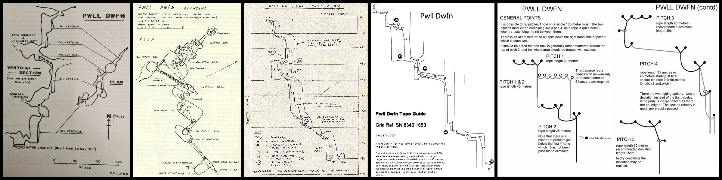
It had no proper survey that we knew of. There was a grade 1 sketch made by Paul and Colin, published by Wessex CC in 1947, which was used on the old Dan-yr-Ogof surveys, the Cambrian cave registry, and even some BCRA geological research. Another draft of it can be seen in the Belfry Bulletin No 195, May 1964. That turned out to be such a rough approximation that the cave is completely unrecognisable. The plan has the Second and Third Pitches completely misaligned and on a bearing which is wrong by 60°. The Fourth Pitch is on a bearing that is wrong by just 15°, is shown far too small (because they only showed the size of the base) and is not sloping. The side passage after Fourth Pitch is on the wrong bearing and shown far too big. The sump is completely misplaced. The elevation is missing the choke below First Pitch, has the wrong shape for Third Pitch, Fourth Pitch is missing the avens and wet rift, and has a non-existent side passage, and the giant aven before Fifth Pitch is missing.
Most of these errors can be assumed to be a result of the very limited visibility provided by the lighting of the era, since in 1947, the SWCC newsletter stated "An adequate supply of [presumably carbide] lamps, candles, and matches should always be carried. Do not depend on others to help you when your light fails.". However, the incorrect bearings of the second and third pitches were explicitly stated in their associated article, suggesting that they had used a faulty compass for that part of the cave, or grade 1 guesswork. The actual bearing of Fourth Pitch is correctly stated in the article, disagreeing with the survey. The depth measurement of 94.5 metres to the sump water level and 97 metres to the bottom of the sump had a 6% error, surprisingly small considering how poor the survey was, and was originally measured with an altimeter. The survey and description appeared in British Caver volume 17, 1947, and the article is well worth reading, to see the limited equipment and safety procedures that were used for exploration, revealing an inability to see avens just 6 metres above the floor, about 4 metres overhead.
Dave M. Judson of Craven Pothole Club made another Grade 1 survey in 1962, which is a far better representation of the cave that was known at the time, but stating the depth of 94.5 metres. The directional orientation of most of the cave is wrong by about 125°, caused by forgetting the bends in the entrance passage. Third Pitch is the wrong shape, Third and Fourth Pitches do not slope correctly (which removes some of the overlaps), and the side passages are missing from the chambers. The passage leading to the sump is not aligned correctly compared with the rest of the cave. But otherwise, this is a very good grade 1 survey, and could have been used for navigation of the cave known at that time. It is the only early survey to show the giant aven before Fifth Pitch, but shows two of them instead of one (there is also an ascending rift in that chamber, but that is not shown). This survey was included in the CPC Journal 3(2) 1962, and it is well worth obtaining a copy, just to read how the cave used to be explored using ladders. It also shows that the little aven above the rift connecting the Third and Fourth pitches had been found, and was used to thread a belay for the ladder.
There are also a few rigging topos, with Adrian Fawcett's being perhaps the best known from 2015, but predated by one from the Cambrian Caving Council in 2000 based on P-hangers (which showed walls) and at least another one by Charles Bailey based on the old spits, published by Brynmawr Caving Club in 1988. (That survey also credits Grievous Bodily Harm as a surveyor, for a joke.) Charles's topo was very well suited to its purpose, and is what Brynmawr members used back in the 1980s and 1990s. Its main oversights were the missing entrance side passage, the missing choke below First Pitch, the missing wet rift and soaring aven at Fourth Pitch, and the missing giant aven before Fifth Pitch. The better quality lighting of the era should have made the avens quite visible. The depth of the cave was shown as about 92 metres to the sump. The 2000 Cambrian topo completely missed the giant aven before Fifth Pitch as well, or at least drastically misrepresented it as being part of Fourth Pitch (even though lighting was definitely good enough to see it by then!), as well as the choke below First Pitch, and had a bizarre extra aven stuck on the side of Third Pitch, which might be a misplaced attempt to show the balcony at the end of the pitch. It is, however, quite usable, if you only want to see the main route to the sump.
Adrian's topo intentionally omits the walls of the cave, a design choice that leaves the cave unrecognisable, and while removing the clutter can be useful in some cases, it can also make it challenging to find some of the P-hangers. The decision to have it not to scale makes it easier to fit all of the P-hangers onto a smaller page while remaining visible, but it also makes it harder to work out where they might be. This is, however, a matter of taste, and some cavers will no doubt prefer it that way. It shows only the main route and a single one of the alternative options (in the wrong place though, and without its rebelay), missing out more than half of the current rigging routes, even though the vast majority of the current cave was already known by 2015.
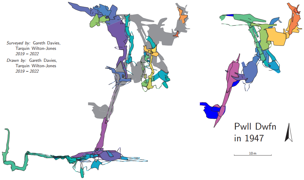
However, the cave is nearly four times as long as most people seem to know about, and most of it was not on any survey. For those who say it does not need a survey because the pitches just follow on from each other and there is nowhere else to go; you missed out on most of the cave, and you are only visiting what was known in 1947. Although Descent 214 reported a connection in 2010 that created the second highest pitch in Wales, it had yet to appear on any major rigging topos. Gareth had tried to survey the cave once before with Malcolm Stewart and Brian Clipstone, using semi-traditional compass, clino, laser range finder and plumb surveying, which proved especially challenging with all of the sloping pitches. Their survey ground to a halt at the Third pitch. The emergence of Distos had finally made it possible to survey the cave with relative ease, and draw it up in a modern software package, Therion specifically. Each of us owned a DistoX2, and Gareth's device was used for almost the entire survey, with mine used only for a tiny piece of surface survey. We were aiming for BCRA grade 6d. Why? Because that grade is quite obtainable when using a Disto.
This was supposed to be a simple project lasting just one winter. It was November 2019, what could possibly go wrong?
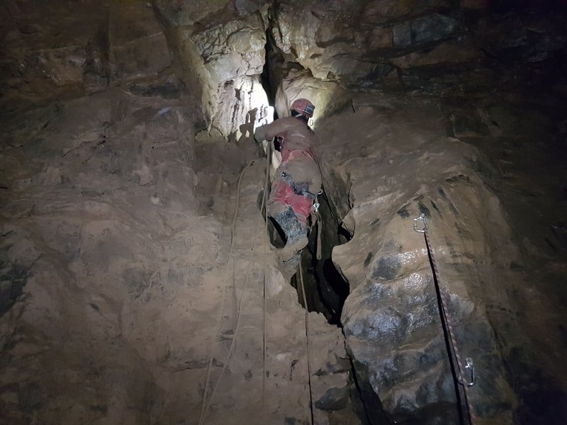
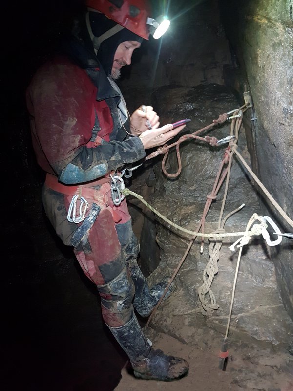
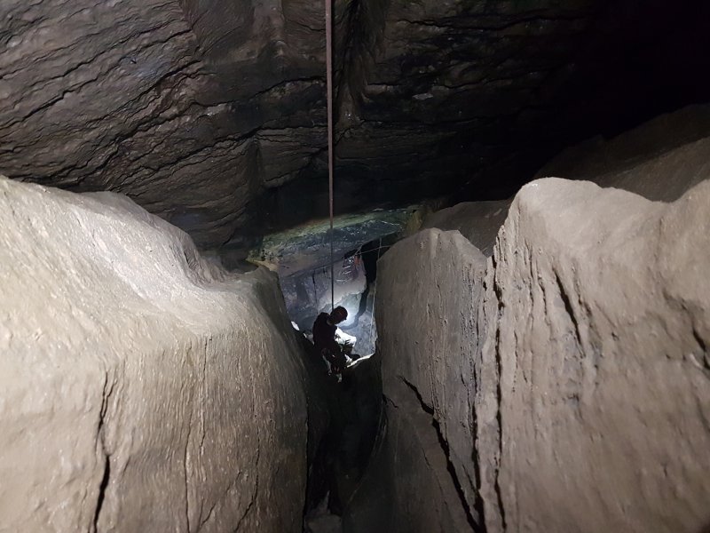
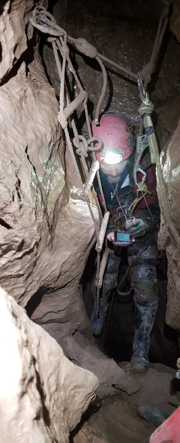
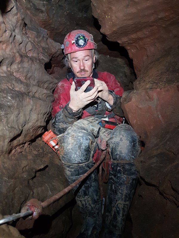
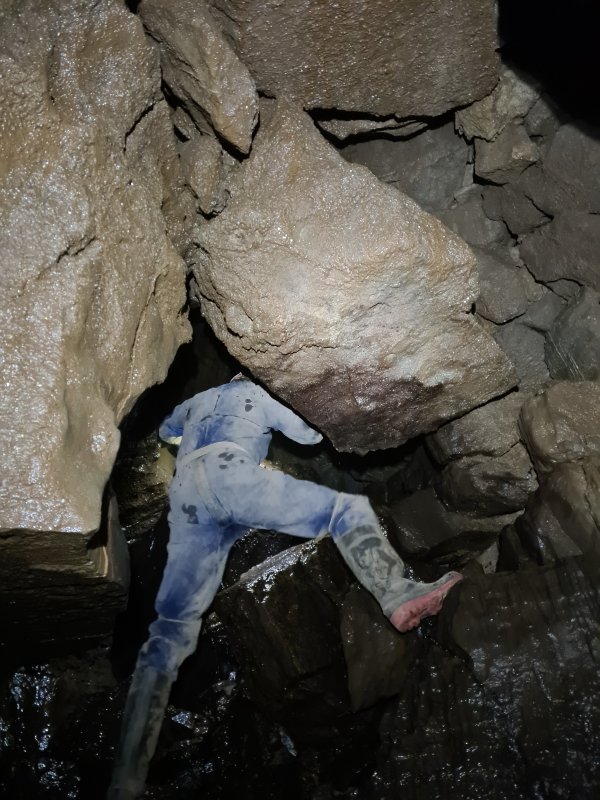
Gareth was normally in control of note taking on an Android tablet, using SexyTopo. I was normally in control of the Disto, training Gareth, and keeping track of all the parts of the survey that still needed to be completed or corrected. At the same time, I was taking a great deal of photographs and videos, to help draw in the details that we might not realise were important at the time. Vertical caves are not at all easy to survey or draw up. Using a Disto is the easy part. Sketching the cave immediately proves challenging, as the stations, legs and splays are all stacked vertically above each other, rapidly becoming a mess of lines, with the surveyor trying to make sense out of it all. The developer of SexyTopo was busy adding features for us, trying to help us focus on the current set of splays. Surveying pitches is hard for other reasons too. Disto readings can be badly affected by metal, and you are covered in it. The stations need to be placed in locations that can be reliably reached, and while dangling and spinning around on a rope, you need to aim carefully at the next station which is positioned down below your feet where you might struggle to see it. Additionally, you can easily end up spending enough time on a rope to have blood flow issues.
When drawing up, nothing lines up nicely, and you have to make constant decisions about how best to render the base of the pitch when it sits far to the side of the head of the pitch. All those sloping walls mean that the outer-most points of the passages are not where the walls feel like they are when you are at the bottom, but they might be where you thought the walls were when you were at the top. I had already experimented with how best to draw up rigging topos, and had quickly settled on the idea that in potholes, extended elevations were the way to go, but until you have a large part of the cave surveyed, you are blindly creating elevations that might not work when loops end up needing to be closed, which they most certainly would in this cave. In general, whatever was taken in the cave will never be suitable for the final rendering, since the passage may need to fold left or right in places you did not expect while drawing it, and you end up simply joining the dots in the cave, instead of truly representing the way the passage behaves. Perhaps I am a cynic.
We started surveying on the 3rd of November 2019, reaching the head of the second pitch. We included both side passages above the first pitch, including the inlets that source the stream from beneath the dry valley, but the winter water obscured the routes through the choke part way down. On our second trip, on the 9th of December, we left the ropes in situ, with a note saying that they were for the surveying project - an approach that had also been used from 2011 to 2014 with the diving projects. They wouldn't be there for more than one winter season anyway, right?
We immediately settled into our standard routine; survey some cave, usually in an evening after work, then come out and work on the survey on a later date, when both of us had an evening free to work on it together. All while trying not to overload Gareth with information about Therion, despite him having jumped in at the very deep end with a complex, vertical cave. In general, only 3 hours could be spent at a time drawing up, which might only be enough to set up the data files with all the details of who was involved in the survey, what equipment was used, which station was the entrance to the cave, which legs were on the surface, and which legs were duplicates. To make our lives easier, I was taking the data as soon as it appeared, and doing that same work while putting it into Survex format, which we could then copy into Therion. I would identify which splays were pointing to hangers for the rigging topo, and start to experiment with the extended elevation layout, before I lost the memory of what everything meant.
In an evening, we might only get the walls drawn, and perhaps some boulders or the edge of a pitch, as we discussed which splays were actually touching which feature. It is my experience that even when familiar with the cartography side (drawing up the survey), it takes an order of magnitude longer to draw up a cave than it did to survey it. Sure, the walls can be drawn in the pub after a trip, but adding all the details of pitches, ceiling steps, boulders, and water flow take time. This does, of course, depend on how much detail you want to draw, but we knew the cave would be very compact, and at high resolution, we would want details like boulders and ceiling steps. While Gareth drew, I would be looking at the same survey in Survex, to try to work out which splay in the jumbled mess of splays was the one he was supposed to use. It would typically take 3 evenings together to draw up the data from one survey. Sometimes a couple more.
I tend to rely quite heavily on my memory of the cave to decide how to draw things up in cases where my sketches did not show something that I needed later ("there is an alcove at that point with a sloping floor made of shingles, and a small inlet which flows out down a dip behind a boulder"). For Gareth, it really helped to have something visual to help see what his survey sketches had been trying to represent, especially early on when he was learning what things were worth drawing while in the cave. Often, a photo or video would need to be checked to prove that a splay really had been aimed at a specific feature, or show that something had not been realised correctly while surveying. So while he was busy drawing lines in Therion, I would be scanning through my videos to find the 3 non-blurry frames that showed whichever feature we needed to see.
Once we had finished each evening, I would painstakingly go over the survey, working out if we had made any copy and paste mistakes in the data files, or errors in which splays we had used. I would then redesign the extended elevation, folding the legs left or right to represent the passage better, and we would repeat the evening sessions for the extended elevation. The extended elevation was much easier, since it did not need much detail, but it did need the rigging. Gareth did the first few ropes to learn how it worked, but drawing up the rigging quickly became my job. The extended elevation often involved having to work out where a splay should have been, because it did not get placed anywhere useful by the extending algorithm. This was painstaking work.
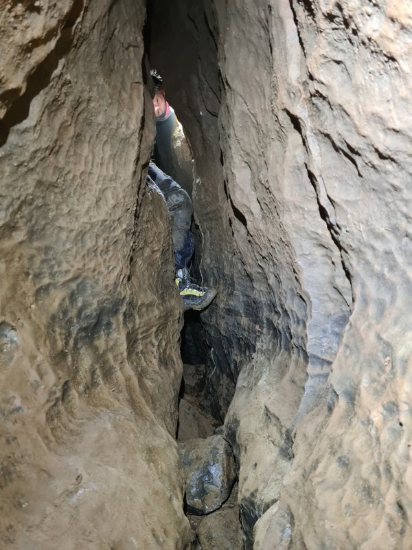
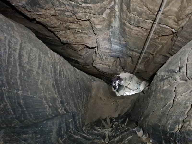
The second trip ended at the blind outlet at the bottom of Third Pitch. The third trip added in the narrow rift continuing ahead at Third Pitch, which climbs up to an upper balcony with a choke. Immediately, the sloping pitches became a problem, because the head does not sit over the base, and the rift remains very narrow. Fourth Pitch presented the same problem. Several soaring avens would need to wait for another day. We tried to add splays, to get as much detail of the pitch as possible, but the winter water levels were fogging up the pitch, preventing the Disto from seeing far enough. This meant that we would need to gather more splays another day, which is particularly troublesome when drawing up in Therion, since it generally only works with one surveying trip at a time. Our standard approach of staying 1 rebelay away from each other so that we could communicate, proved particularly difficult with the noise of the water. The falling water at the bottom caused the tablet to stop working, and we lost the ability to draw sketches there, but managed to keep gathering data to end the day's surveying somewhere more useful, in the chamber below the pitch. The water levels were high enough for the base of Fifth Pitch to be a backed up pond, with all of its rocks underwater; not ideal conditions for surveying wet pitches. The missing sketches were created later using photographs and video, and the detail from the splays.
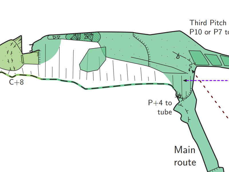
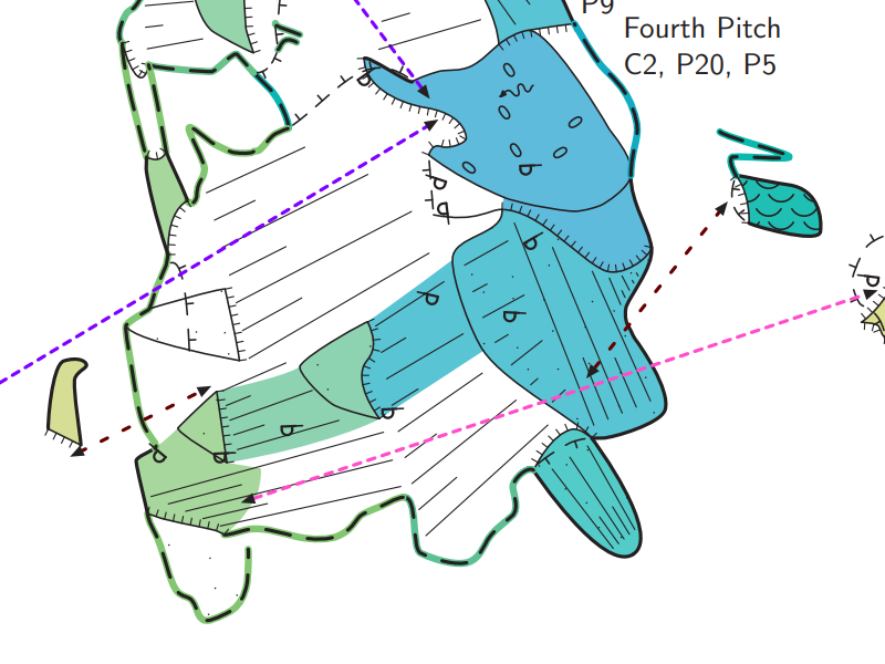
When trying to draw up the data, we tried showing the full widths of the passage, but Third Pitch looked enormous, so we decided to follow the standard approach of showing the narrow width, with the outer-most wall shown as a presumed/dashed line. Adding colour to the dashes helped to show which dashed line belonged to which passage. At least, until there were too many passages stacked above each other, something that would become a running joke as the survey progressed. The passage leading to Fourth Pitch ran underneath Second Pitch, and below it, a cascading inlet brought the water from Third Pitch, also passing below Second Pitch. The chamber below Fourth Pitch also passed below Second Pitch, giving 4 overlapping passages in the plan. Surveys have sometimes been known to displace passages to remove overlaps like that, or simply avoid drawing them completely. But with Disto surveying and Therion designed to accurately represent what the cave really does, we had to work out how to render it usefully. As it was, it looked like you descended from the head of Fourth Pitch, and ended up bypassing the bottom, landing in the chamber that lay beyond the pitch. Pulling the colour from the base of Fourth Pitch was impossible, because it would need to overlap the drop that lay right below the pitch. We hope you like the compromise we came up with, pulling a band of colour from part way down the pitch towards the head of it.
However, it was already very apparent that the plan view of the cave would never be useful for navigation. Detail or no detail, there were already too many passages overlapping. The extended elevation would have to be the main way to navigate within the cave, a common thing in potholes. The plan exists mainly because people like to see plans, and we could include a level of detail - boulders, sediments, notes - that were not going to be included on the more simplistic extended elevation. The extended elevation, however, needed us to get some idea of how the round trip's loop would close before it could be drawn up, since passages may need to be lengthened, shortened, or folded differently, in order to make it connect. Until we had some data from CUCC Old Flyover (which would be some time away), the extended elevation drawing was put on hold.
I made Gareth do the first set of joins between the sections of the survey, so that he could learn the process in Therion. But we were only surveying small amounts each time, and the surveys kept ending in very complicated places. So I took over the joins between surveys, getting the lines in each survey to match the positions of the lines in the previous survey, and creating the join commands. Splays from the next survey would sometimes show that the previous one was missing some feature, so I would work out the correct positions, and transfer them into the previous survey. When a pitch got twisted part way down by the extended elevation, we would have to make the decision about how the error would be hidden, something I would usually decide beforehand. An example was where First Pitch joins Second Pitch - they are oriented at 90 degrees to each other on the extended elevation, but they are in line with each other in reality. Gareth would then critique my design, and decide which approach felt more natural. This was very much a two-person process.
As 2020 rolled in, we surveyed from the chamber, starting with a very narrow crawl that formed an oxbow in its ceiling. This became the fifth passage in the stacked mess at the edge of Second Pitch. The small aven at its end appeared to have an unpushed way on, but some dodgy free climbs up the wall proved it was blind. The short side passage in the chamber is perhaps the least interesting in the cave, but is one that many people have visited in the past, as it is the only one that is easy to reach. The way on has two options, a rift or an undercut below boulders, both of which sit below the existing stack of passages. There were now seven passages in the stack.
The base of the next big aven, where a lot of trips turn around, had a further side passage, directly above the descent to Fifth Pitch. This had been bolted into by someone, gaining a whole 9 metres of passage. Though it forms an oxbow with the head of Fifth Pitch, it also continues beyond, into unknown territory. Its reason for existence is unknown, but a narrow rift in its ceiling climbs a surprisingly long way. We reused their bolting, staying on the rope while we surveyed, just in case the floor collapsed into Fifth Pitch. We ended the day's surveying at the head of Fifth Pitch, whose rocky ceiling is made up from the floor of the passage we had just surveyed.
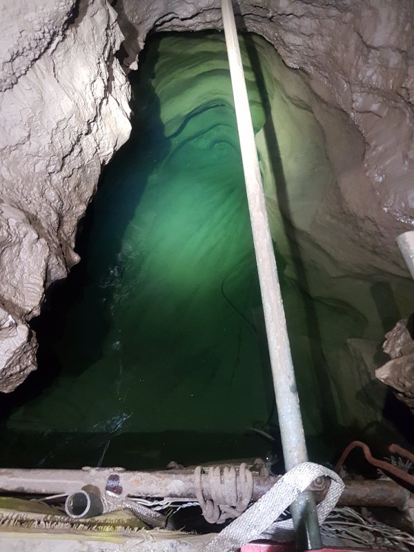
The next trip saw us survey down Fifth Pitch, probing the depth of its pool with a rod. We were accompanied by George Linnane (yes, before you ask), who was just on a tourist trip rather than surveying. The rift to the sump swallowed a great number of splays, showing the chaotic lattice of passage in its ceiling. We reached the sump, recording the water level, but being unable to see through it. We assumed we would have to rely on the minimal survey recorded by Gareth and Malcolm while digging in the sump between 2011 and 2014, following in the footsteps of Mike Barnes, who had dug there in 2010. Our survey showed the sump was at 100.4 metres depth, 80 metres above where the water is next seen in The Washing Machine, in Dan-yr-Ogof. The passage on the far side of the sump pool had been known as an inlet, reached by a rope traverse over the pool. Joel Corrigan and Matt St.Clair had installed a scaffold bridge over the pool, later filled with digging spoil from the sump. The rift above the inlet was pushed by Joel and Martin Groves, then by Gareth and Richard Frost, but the breakthrough into Enterprise Aven was finally made by Gareth and Malcolm in 2012, resulting in the biggest extension in the cave that nobody seems to know about.
Our survey reached the base of the aven, and George left us to make his exit. We turned our attention to the other extension, made by Richard in 2011-2012, and named Poacher's Passage in honour of Malcolm's involvement in Enterprise Aven. The traverse from Fifth Pitch's head used the ropes that dated from that exploration, always a little exciting. We surveyed through the chamber that had been discovered, past its massive choke, and into the little side passage that departed at the top, heading into the unknown again, and ending in silt. We continued up into a chamber above the choke, but an aven above that needed protection, even though it looked like it had been free climbed in the past. This had every appearance of a great lead, perhaps reaching up into whatever lay above the choke, but the choke would be an almost impossible prospect for pushing. We returned with removable anchors to climb into it another day, and were thoroughly disappointed when it immediately choked. This area sits below Third Pitch's balcony, yet another stack, this time with 4 levels of passage.
On the Fifth Pitch surveying trip, as I reached the head of Third Pitch on the way out, I heard Gareth hurling insults in George's general direction from the base of Second Pitch. On his way up, George had pulled the rope up through the deviation on Second Pitch, all the way to the bundled knot in the end of the rope. It looped down towards us, then back up to the top of the pitch, but neither of us could reach it, leaving us stranded at the bottom. We were aware that CUCC Old Flyover could perhaps offer an alternative route out, but that would mean ascending ropes without being able to perform safety checks on the rigging, which had been in the cave for many years without inspections at this point. After some brainstorming, we donated our cowstails and footloops, and created a length of rope. Standing on the rock pillar at the bottom of the pitch, I was able to throw our makeshift grappling hook through the loop in the main rope after a couple of tries. We were hoping to be able to pull it hard enough for the rope's stretch to bring it within reach, but instead, the knot at the end of the rope came undone, allowing it to fall out of the deviation (which is pointless in low water anyway). A very lucky save. George got really close to owing the rescue team a barrel of beer - what a dreadful responsibility that would be, eh?
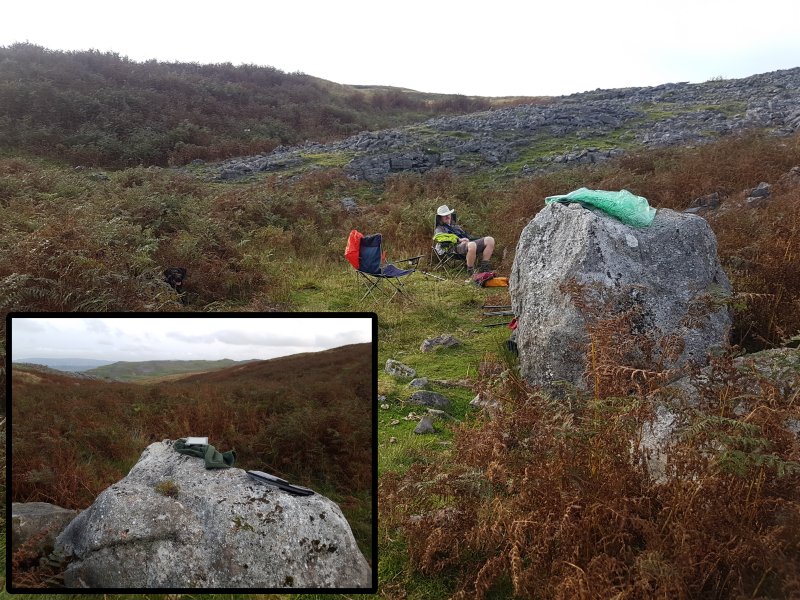
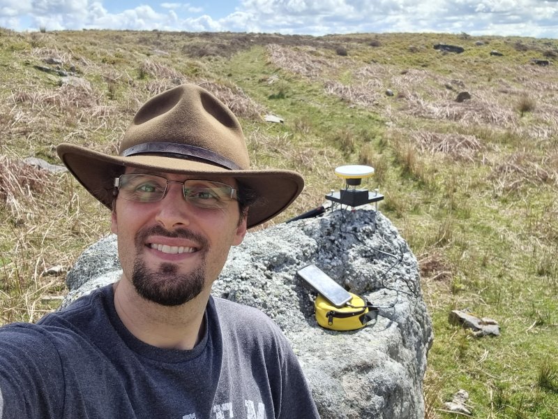
I convinced Gareth that we should survey the surface. Many surveys have relatively minimalistic surface surveys, covering vast distances to link local cave entrances, but often ignoring features along the way. Some might overlay a Google Maps satellite image, with altitudes based on ASTER GDEM (LiDAR) data. But I had proposed surveying the entire surrounding little valley, shakeholes and all. Why? Because the publicly available ASTER data of the area is, to put it mildly, terrible. And yet this is in a place with no trees, and no other obstructions that could have affected the scan. The floor of the valley that Pwll Dwfn sits in, is shown as up to 5 metres too high, particularly at the location of the entrance. Meanwhile the banks around it are shown as 5 metres too low in places. This results in the valley being reduced to a shadow of its former self, making it completely useless for working out how close each piece of the cave is to the shakeholes above it. With our surface survey, we can see the shape of the valley (which varies from 2-18 metres deep), use it to see where the former sinks were, and we can see that the shakehole above Second Pitch sits just 4.8 metres above the pitch's ceiling.
Starting on the 24th of January, we started the surface survey, working on dry winter nights to maximise the surveying time, since the laser is almost impossible to see in daylight. For temporary stations, we used a pair of tripods, occasionally saving our progress with a slightly more fixed station on a rock. Within two trips, we had surveyed the valley for 125 metres north and south of the cave, and every shakehole in the surrounding cluster. We had planned to add in the digs as well, known as Dig On Black Mountain and Dry Valley Dig. On our third surface survey, we picked up some shakeholes we had missed, with some disagreements as to whether it looked right. We then headed to the digs, and after some confusion on the first dig, we were absolutely convinced that something was wrong by the second dig. The top and bottom of the dig did not line up even a little with each other. We tested the calibration, and it was immediately apparent that the Disto was not calibrated correctly, and was getting progressively worse. This was caused by the cold temperatures forming ice crystals inside the Disto, affecting the alignment of the sensors. We were forced to abandon the surveying, and discard the data. We resurveyed the digs on the last day of freedom before the 2020 lockdowns began.
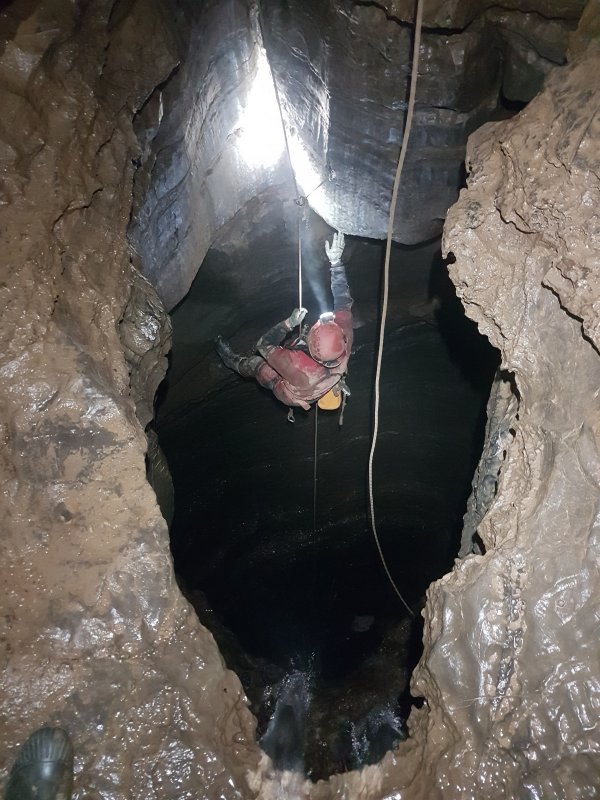
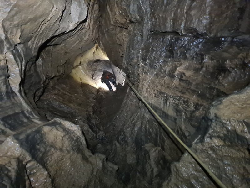
It was 4 months before the lockdowns allowed us to resume surveying, and we headed for Enterprise Aven. The sump was crystal clear, so we surveyed it almost completely with me lying on a scaffolding bar perched above the water, using measurements of the refractive index to correct the Disto lengths, comparing them with the depths measured by the divers. The cave's total depth was found to be 104.45 metres. Enterprise Aven's impressive height was going to be quite a challenge for me, as it is the third highest pitch in Wales. The ropes hanging on it dated from the original exploration, which lasted until 2013. We surveyed to the traverse ledge 12 metres off the floor of the most impressive part of the pitch, before my nerves requested a break.
We turned our attention to the second highest pitch in Wales, the small passage termed the CUCC Old Flyover. It leads from the rebelay in Second Pitch, bypassing most of the Second Pitch, and all of the Third Pitch, to emerge at the top of Fourth Pitch's aven. After a false start with me leaving my SRT gear in the car, and having to return all the way down the hill and back to get it, our survey started at Second Pitch. We managed to survey the traverse, though the rigging metalwork was definitely worn to the point that it needed extra protection. On the far side, the survey of the sandy ledge seemed to make sense. We spotted a completely unclimbed aven in the ceiling, leading up into virgin passage, which we would need to aid climb into another day. Gareth started mumbling about my splays showing that the aven was more displaced than I realised, but managed to make sense out of it.
The ongoing blasted squeeze had been reported as being epic, and certainly from the rebelay, it looks impossibly tight. However, it is barely worthy of being called a squeeze, and is really just a narrow crawl, though it does get tighter at its end. It does require SRT gear to be removed, while perched on a ledge made from sand, nearly 14 metres from the floor of Second Pitch. Surveying in tight spaces is always difficult (though a Disto is dramatically easier than traditional surveying), and Gareth muttered something about my splays pointing in bad directions, maybe as a result of some metalwork being too close to the Disto in the confined space. A calibration check proved that yes, the Disto had lost its calibration, and was giving nonsense results in some directions. There was no way we were going to re-calibrate in the narrow passage, or at the head of Second Pitch, so we called it a day, and set about checking the ropes at the head of the big pitch. (Oh good, at least I have an excuse not to do the pitch now.)
The main rope had been installed by Joel at the very start of 2011 when he re-bolted the pitch for SRT, and the ropes were apparently already "old work ropes" at that time. However, they and the metalwork passed our inspection. The older rope following the line of the original bolt climb that Joel and Matt had used to get up the aven, seemed to be less trustworthy, but we had not planned to use it anyway. There was definitely some staring with disbelief at the insanity of its rebelay.
Worried that the Disto might have a fault, we recalibrated in Powell's Cave, getting a reasonable coefficient of around 0.35%, which was about as good as we could ever get with Gareth's Disto (mine would typically manage nearly 0.2%) - anything below 0.5% is considered acceptable. At least it was still working, and Powell's Cave could be used before our surveying trips when needed.
A few days later, we returned to Enterprise Aven, to make our way into some rifts that we had spotted during the first survey, each part way up the pitches, with no floors or ledges to walk on. The original exploration had concentrated on the climb, leaving any side rifts unexplored. Our splays had shown that two of the rifts reached an incredible distance away from the pitch, and we wanted to see if they were just an expansion of the pitch's rift, or a separate inlet in their own right. Gareth added protection in the form of removable anchors, while I belayed. Sadly, neither rift revealed any potential, though the one to the east did have a very narrow aven climbing upwards for a significant distance, the source of which is not known. It points back towards the dry valley, but 60 metres below the level of the valley floor. On our way out, one of Gareth's belt clips failed, dropping an expensive electrical tool down a pitch. We watched it fall and land 9 metres down with a heavy thud. One bent piece of metal needed to be discarded, but the equipment was revived with a bodge job a few days later.
We returned to survey the next section, which had been a daunting prospect for me, not least because the next stage involved a swing out over the gaping chasm. However, the aven turned out to be nicely broken into sections, leaning very significantly sideways, so that although you can nearly see the floor from the top, there is always a substantial ledge not far below you. The next rebelay had a passage trending west, ending at a small waterfall, stacked above the bottom of Enterprise Aven. Above that, a traverse ledge had something very similar, with its water feeding the aven below. Another passage for the stack. The next ledge marks the top of the main pitch, 33 metres above the proper floor, 40 metres above the Enterprise Aven breakthrough. The aven continued upwards past jammed rocks, but another passage headed west, this time a little longer, with a large rock bridging the passage. Again, it ended at a small aven, beyond a squeeze. Each of these passages overlaid the one below it, now 4 passages in a stack. Drawing this up was going to be challenging.
We returned a month later, calibrating in Powell's Cave on our way. We continued upwards in Enterprise Aven, where the final 7 metre rope reached the jammed rocks, but no solid floor. We remained on the rope. The ceiling above was the highest point in the aven, 48 metres above the breakthrough. A tiny tube seemed to feed back into the main pitch. The westwards rift continued at two levels above the passage, neither of which had a solid floor. Each stage of the rift is basically just an enlargement of the same passage. The highest one is the way on, a body sized widening that you post yourself into, from a pitch head with no ledge to stand on. One more level for the stack, that makes 5. The first few metres have no floor at all - the floor is 6 metres below, two or three enlargements down. It is small enough that SRT gear should really be removed, at the pitch head where there is nowhere to stand, without falling back down the pitch. No wonder very few people have ever seen the other side. We carefully transferred our cowstails onto our belts, and clipped into each other and knots in the hauling line, so there would be some pretence of safety. The SRT gear was hung on the pitch head.
A Thrutch Too Far is not tight, and really is not all that much work, but the slot in the floor may snag small tackle bags. A climb up then reaches a walking sized passage. We surveyed the thrutch, the passage, and into a blind aven, which apparently gets very wet in high flow. Our survey confirmed it to be the highest point in the passage. Beyond it, the passage ascended a climb and reduced in size, narrowing to a squeeze, and ending at a calcited silt blockage. What a sad end after such a grand pitch. Water could be heard trickling below the floor, so presumably it is another inlet.
Our hopes were that the aven might either nearly break surface, or that the passage might reach back towards the known cave. This might at least offer a possibility for creating a route into the top of what is a very fine shaft. However, the previous survey had shown that we were still a long way from the surface, and we could immediately see that the passage pointed far away from the known cave. Our survey confirmed that the highest point in A Thrutch Too Far still lay 47 metres lower than the deepest shakehole above it, and the nearest piece of the main cave was over 35 metres away, in the wrong direction. Enterprise Aven is clearly an entirely separate development, which just happened to meet Pwll Dwfn before the sump. We had discussed removing the old rope, but it would essentially banish Enterprise Aven into obscurity, never to be visited again.
On our way out, we spotted that the reduced flow had given access to the choke below First Pitch, and it seemed to go a lot further back than the initial survey had shown. A careful visit revealed a loose cavity, and a boulder trap arch leading into an alcove with a fluted aven. We tried surveying, but the Disto simply errored out constantly, being unable to get a reading from the very wet walls. With the tablet's batteries too low for us to have the time to fight with the Disto, we gave up, and tried to come up with ways to get readings - shooting into a bean can that is dry inside, maybe?
A few days later, we returned to resurvey the CUCC Old Flyover, armed with equipment to climb into the initial aven, using removable anchors. This time the Disto did not let us down. We bagged the 5 metres of virgin passage at the top, which promptly dropped down the last 18 metres of Second Pitch, confirming that this was indeed the rift that we had spotted in the wall of the shaft. Clearly, this was the original way that water had made its way from First Pitch into CUCC Old Flyover. We then resurveyed through the squeeze, and reached the head of the big shaft. I informed Gareth that my nerves were telling me that today was not the day, which is fortunate, because it was already late, and we would have needed a lot more time to complete it. We had not really expected to do the pitch that day anyway, but Gareth had got his hopes up. The data immediately added to the existing joke, as two more passages joined the crazy stack overlapping the edge of Second Pitch. Up to 9 now.
We fired some splays down the pitch, trying to hit the rebelays so that we could make a head start on the rigging topo. The splays managed to intersect some of the splays we had shot from below, proving that we had at least managed to measure the shape and height of the pitch. With the positions of the top and bottom of the pitch now known, I was able to work out the best alignment of all of the passages for the extended elevation. It was, rather fortunately, likely to have the two ends of the round trip's loop meeting up fairly well, removing the need for any "this part connects to this other part" dotted lines.
As part of the survey, we wanted to establish a proper grid reference for the cave. There are several grid references in various sources, each with their own degree of error. With all of them disagreeing with each other, we could benefit from working out the actual coordinates. The Cambrian Caving Council and Caves Of South Wales (1995) used to give a location with an 82 metre horizontal, 1.75 metre vertical error. The 2022 Cambrian Cave Registry and ogof.org.uk are a little better with a 7 metre horizontal, 0.75 metre vertical error - the amount that might be expected from a consumer grade GPS device, but that vertical error is impressively small, so it probably comes from a digital elevation model. The OS have an error of 77 metres horizontal, 3.75 metres vertical, presumably to avoid overlapping symbols. OpenStreetMap has an error of 14 metres horizontal, 0.75 metres vertical. The Wessex were 60.5 metres wrong horizontally (specified as Airy 1830 geodetic coordinates, no less!) and only 1 metre wrong vertically. The Craven were 8 metres wrong vertically, and did not give a horizontal position of any accuracy (just a 1 km grid square). For once, Google Maps or Google Earth was the closest with a 1 metre horizontal, 1.75 metre vertical error. Their imagery does jump it around in different years though, sometimes 1.4 metres horizontal error, sometimes 0.42 metres. Don't let this relatively fortunate case fool you into trusting it for your surveys, because its errors are often vastly worse elsewhere, and this really is an example of pot luck.
Special mention should go to the Meithrin Mynydd project, run by SWCC. In August 1997, when differential GPS had only just become available, the Meithrin Mynydd project recorded a location with a 3.75 metre horizontal, 5.75 metre vertical error, using a backpack-mounted differential GPS device that was supposed to give 40 cm RMS horizontal and 80 cm RMS vertical accuracy. In case you are wondering, it was a Steanne Solutions system based on the LandStar MK III receiver system and Ashtech G12 GPS Board, with corrections sent via LandStar's geostationary satellites. More details available in SWCC's Meithrin Mynydd Black Mountain Cave Survey, Final Report Of Findings, November 1997. That is something regular mortals could only have dreamed of owning, but the results were clearly not as accurate as predicted, even if they were far better than a consumer grade device of the same era. Note that the error is not caused by the use of Helmert conversion instead of OSTN15, as converting back using Helmert transformation and then applying OSTN15 instead, only makes the error even worse. The error is also in the wrong direction to blame continental drift, which could only have caused a 20 cm error at that date. The error also could not have been caused by the GPS system's use of selective availability, as that would have been counteracted by the differential GPS.
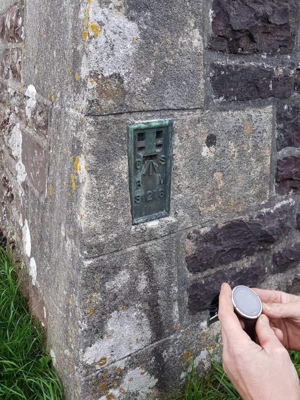
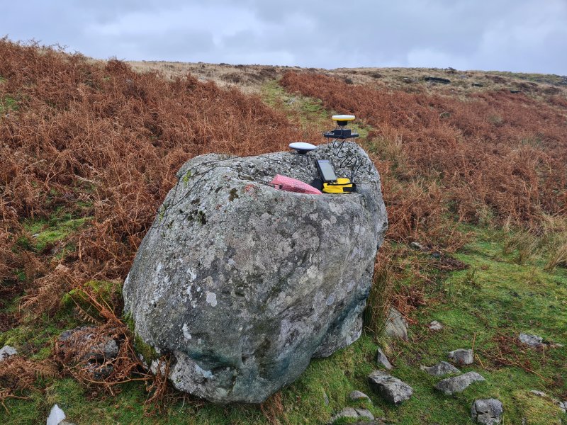
We (well, I) wanted our survey to be as precise on the surface as it was underground, so that it could be properly linked into other surveys which were fixed using precise local benchmarks. It seems pointless to have a Disto that can measure distances within centimetres, and then to add a 15 metre error by using a poor location fix. It would be easily possible to just walk up to it with a consumer grade GPS and take a reading, but these are far, far less accurate than the manufacturers would like to claim, and we were surveying, not making an orienteering marker. Normally, the approach is to link up with someone else's surface survey if there is one, so that all local caves can share the same errors, but we do not know of one, so would have to create our own, a daunting prospect. Our nearest benchmark was at a church in the valley, or a mountain 2.5 km away, but surveying from either of those would have incurred a 5 m error at the best accuracy. The benchmark had its own 10 metre uncertainty, while the mountain had only a few cm, but with the distance away, the result could be beaten with a good GPS, and would be far less work. So it had to be a GPS.
The biggest accuracy issue with a GPS is altitude, so we tested altimeters, with comically bad results; an error of 23 metres, or 12% from the nearest benchmark, where we had calibrated just 38 minutes beforehand. We tested handheld GPS units (yes, you know the brand), and the results were found to be almost nonsense, often with the devices giving fake results, such as using a low resolution digital elevation map. So instead I bought a GPS unit with 1 metre precision, aimed at industrial use. After running a lot of tests to learn how to get the best results, and to prove that it actually performed better than a standard GPS unit, we were going to start using it for weighted GPS averaging in September 2020.
But then Gareth decided that he had not had enough of being stuck indoors, and it would be best for him to catapult himself off his bike in order to avoid a close encounter with a furball, and broke his collar bone. So he was out of action for the forseeable future, and missed out on almost all of the freedom between lockdowns. I ran the first day of averaging on my own, becoming frustrated with crashes and unexpected app behaviours. For the second day, Gareth joined me, calibrating in Powell's cave again, then spending most of the day snoozing away his injury while I babysat the GPS. In the evening, we resurveyed the faulty part of the surface survey.
We now had 21'700 surface location samples to average, spread over many hours on different days, with a GPS claiming to be accurate to 1 metre. As it turned out, the position error of our 4 sets of averages ranged from 1.7 to 2.4 metres horizontally, and between 16 cm and 1 metre vertically. Not bad, but it is clearly not as accurate as it would like to claim. At least it was better than the 1997 differential GPS, and better than any current handheld devices.
We spent another 8 evenings drawing up the data from Enterprise Aven, CUCC Old Flyover, parts of the surface and the digs. Just as Gareth had nearly healed enough to go caving, the lockdowns started again. The inconvenient timing of the lockdowns meant that each of us found our own projects to entertain ourselves with, and once out of lockdowns, very few evenings available at the same time as each other. It was a full year before we were able to work on the survey again together.
For much of that year, I learned about how to do more with GPS data, post processing raw satellite messages, and applying correctional data from local base stations, to get locations down to within a few centimetres, using the same length of captures as we had been doing previously. After several trial runs, my brother Peter Wilton-Jones and I had managed to get this down to a fine art, but it was painfully laborious. Then we found out about the Trimble Catalyst differential GPS that can do it all, just like those insanely expensive units that land surveyors use, but at a price that cave surveyors might actually be able to afford. 2 minutes to set up, 1 second to take a reading at 2 cm accuracy. At that accuracy, surface surveys to get between caves are unnecessary, as the locations can be plotted with far greater accuracy than any surface survey could ever achieve. I was convinced, and my pocket weighed a few hundred pounds less. Peter then followed suit with a DIY version made by ArduSimple that could only use free differential sources, typically set up by farmers or enthusiasts, without any assurances of their own accuracy. However, we found one that seemed to give results down to about 6 cm accuracy, though setting it up required a lot more technical knowledge than the Trimble.
13 months after his accident, Gareth and I were finally ready to get back into the cave, this time with Pete Bolt joining us for a tourist jolly. Another pit-stop at Powell's Cave to calibrate, testing that the uploaded calibration had worked, as always. We then headed up to Pwll Dwfn, to start a new survey at the head of Second Pitch, while Pete went off to check the ropes in the rest of the cave. I shot a few splays down the pitch, but Gareth noted with some confusion that the splays all seemed to be pointing vertically down, rather than spread over different angles. Checking the Disto's screen, it showed that indeed, anything below level was being given as -90°, and anything above level was being given as 90°. At roughly level, even the slightest twitch would cause it to measure huge jumps. Something was definitely not right with the calibration. We put the Disto back into calibration mode, then just uploaded the day's calibration to it again, and it worked properly. Presumably, in the time it took us to get between the caves, the Disto had experienced a software fault, and had reset itself, removing the calibration. A reminder to save a copy of the calibration, because you never know when it will be needed again.
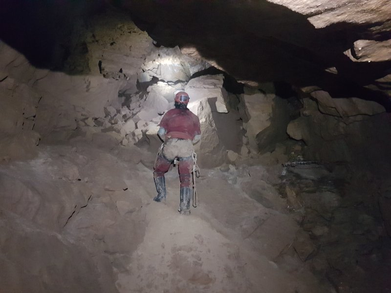
With the Disto working again, we started surveying the route through the choke below First Pitch, an area which feels like it wants to drop its giant boulders on you. This resulted in the second passage stacked below the entrance passage. We carefully surveyed the wet alcove that had defeated us last time, this time with no issues, and splayed into a loose route under the choke, the fourth passage in the entrance stack.
With the project resumed, we attempted to catch up with all of the cartography work that had not yet been completed; work that was interrupted by a rather lengthy trip with George. A couple of weeks later, my brother Peter and I tried to use my new GPS to re-fix the survey location, but sadly a software mistake meant that our results from that day were not valid. Still, I surveyed a surface shakehole Gareth and I had missed, and we learned about the limitations of the two GPS devices in the mountains, so it was not a completely wasted day. The extended elevation finally got restarted shortly afterwards, rapidly becoming the main navigational survey that it had been destined to be.
In preparation for the next surveying trip, Gareth attempted a calibration at Powell's Cave, but after failing to meet the required accuracy a couple of times, had to admit defeat. On the morning of the next trip, the two of us tried together and got it to work. Having an assistant makes calibration so much easier.
There were just 3 parts of the cave left to survey. We started with the big aven between Fourth and Fifth Pitches. This had been bolted by Pete Bolt many years before, finding only a stupidly tight slot at the top. He named the top of it Loose Slab Aven, as there was no record of the aven already having a name, having been unseen during the original exploration, and only appearing as "high avens" (plural) on Dave M. Judson's survey. Joel and Matt had then bolted it again some time significantly before 2011, leaving a rope in situ. They had enlarged the rift, but nobody seemed to know what they had found. Their rope had later been cut about 3 metres off the floor by someone free climbing the wall, to prevent anyone accidentally relying on an ancient rope. We had no idea what it was anchored to, or the state of the belays. We had discussed re-using the line of bolts to add protection, but in the end, we just used the old rope. Neither of us were tall enough to reach it and Gareth's collar bone limited his climbing. Our attempts resulted in him sitting on my head, trying to reach the rope while I teetered around trying to keep my balance. Some comedy later, I gave up wearing Gareth as a hat, took to re-climbing the wall, and managed to clip a top jammer onto the rope - enough to get Gareth started.
He very carefully ascended the rope, added a new removable anchor, and formed a Y-hang at the old rebelay with our rope that we had taken off Fifth Pitch. The first rope to be taken off a pitch, the 14th of January 2022, after just over two years on the pitch. But Gareth's injury was making the work tiring, and my constant reminders of how much I hated heights and old rope and old hangers, finally got to Gareth, and he retreated. We resorted to picking up one of the other stragglers on the way out. At the normal head of Fourth Pitch, one of the avens had only been surveyed with splays from the pitch head, and we knew it went up further than we had seen. Another ancient rope hung out of it, presumably dating from when Joel and Matt had bolted into CUCC Old Flyover, ending in 2010. Still, it was Spelenium Gold, and it felt fine, even if it did creak like a rusty door hinge.

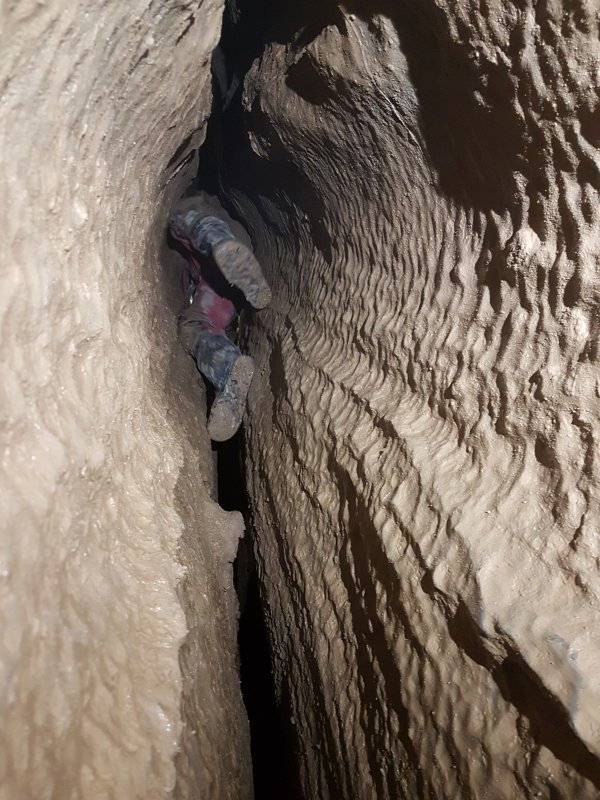
A careful ascent brought us up to a little pitch head, where we could see why the ascent route had gone through a cleft into the main shaft instead. The aven ended just a few metres above our previous splays, but with a tube at the top pointing away from the main fault. There was no prospect of further cave up there. A smaller hole dropped back down to the passage below, turning the floor of the aven into a small rock bridge. During the 1960s, ropes were threaded over the rock bridge to act as a belay for ladders on the Fourth Pitch. We surveyed the aven fully, adding the tenth and final passage into the crazy stack at the edge of Second Pitch, which is formed on 8 different levels in 4 different fractures. When drawing this aven up, it very quickly became apparent that it had a particularly distinctive phallic shape, but although it earned a name because of it, we didn't feel it was appropriate to write "Dragon Dildo" on the survey. Don't go googling images unless you are ready for what you might see.
Our next trip completed Loose Slab Aven between Fourth and Fifth Pitches. Gareth reworked the ropes and added a removable anchor to allow the unused lower rope to be used to make a Y-hang instead of a rebelay higher up. The top already used a Y-hang, and the hangers seemed to have survived fairly well in spite of their age. The rift at the top had clearly seen some action, and a scramble up led through a squeeze under a jammed rock into a passage. The squeeze was enlarged by removing a rock, and we surveyed the narrow rift. It slanted like most of the cave, and climbed up some small ledges to reach a choke. As we had suspected, the choke was positioned 7.5 metres beneath the floor of Third Pitch. There was no prospect of extension here, since the choke would prove extremely challenging to dig, and would only gain known passage, though it would make a round trip. On our way down, we returned the hangers and rope to their original state, and our rope came out of the cave. As a result of this trip, Gareth had become the first (and probably still the only) person to have visited every part of the known cave, even the sump which I would not be visiting.
Armed with some better software, another day on the surface resulted in the location fix, using my new GPS. This time, the results were reliably excellent, and we were able to measure the precision of the results, showing that the fix was well within 1 cm (we measured a total 3D standard deviation of just 6 mm, and thanks to the Kalman filtering we subsequently used, we managed to reduce that to an expected 2.5 mm). The Disto measurements from the location fix (a large boulder) to the cave entrance come with an average error of 40 mm, as measured from the cave's loop closure. Therefore, our location fix can be expected to be within about 5 cm. Though this goes far beyond what a cave survey needs, it is nice to know that the cave's location is actually accurate this time, and the error of all the other methods can actually be measured. Our hope is to set up a differential source covering the South Wales caving area, so that surveyors can use the ArduSimple devices to aid in their surface surveys, virtually eliminating the need to survey between caves, without having to pay licensing costs.
For the technically curious, the device used was a Trimble Catalyst DA1, operating in NRTK mode, using the Trimble VRS Now corrections hub. The corrections were (in 2022) sourced from OS Net base stations, which define the OS grid itself. The output was in ETRS89, ETRF97 2009.756 epoch (the correct epoch for the OS grid), and conversion to grid reference was done using OSTN15, the same formula used by the Ordnance Survey for the OS grid. The individual readings and the EPE (estimated accuracy) of each reading is recorded in the survey's source code, made using a high precision version of GPSTest. The resulting position was calculated using a static Kalman filtering tool that I wrote, taking all of the readings, using the EPE for weighting, separately for horizontal and vertical. The estimated standard deviation of the results is down to just 1.5 mm horizontally and 2 mm vertically, thanks to the Kalman filtering, which says roughly how accurate the position fix can be expected to be. Compare this with the actual error we got from the device that claimed it was accurate to 1 metre, even after averaging 21'700 readings. The device was mounted on a custom levelling tripod, whose height was then subtracted from the result. Phew!
The final surveying trip took place on the 24th of May 2022, two and a half years after the first one. The only remaining piece was the big pitch from CUCC Old Flyover, the second highest in Wales, something I had been very apprehensive about. Before surveying, we realised that the calibration had not been tested in advance, and quickly tested it at the head of Second Pitch. It failed, but only by a very small amount. However, this was a very important part of the survey, where calibration really matters, so we made the uncomfortable decision to calibrate at the head of Second Pitch, the only space large enough to do so. Good calibration requires metal objects to be kept away from the Disto, as well as many lights and other potential sources of magnetic fields. This meant disconnecting from the rope, and removing SRT gear, helmet and light, then stumbling around at the head of a pitch, while trying to point lights at spots on the wall instead of the floor. Gareth carefully guided me around while I calibrated, trying to find objects in the right directions, at one point having to sit on a boulder near the edge of the pitch. In spite of the difficulties, we managed the impossible, getting a calibration coefficient of 0.19, the lowest we had ever managed.
Now ready for action, we headed out onto the old ropes, taking 1 hour and 20 minutes to slowly make our way down to the bottom of the pitch. If I ever wanted to expose myself to the heights, this was the way, but the pitch actually felt great. It slopes significantly, requiring a number of rebelays, and has several sloping ledges that make it seem a lot shorter than its 47 metre total height. Most of the metalwork on the pitch passed the sniff test, but one of the rebelay maillons was definitely partly worn through. The time spent on the rope was not comfortable at all, and blood flow was an issue. For parts of it, I was wedged with my shoulders on one wall, and feet on the other, lifting myself up so there was no weight at all on my harness, and a huge drop below me. Quite an unnatural situation, just to get the blood flowing again. Gareth had sensibly used his Pantin to enable standing up, to achieve a similar temporary respite.
That was it, we had our data, and there was no need to leave the cave rigged, so we took our ropes off the pitches, leaving the old ropes on CUCC Old Flyover. We're sorry that our 1-winter project took so long! I meticulously measured the lengths of all the ropes, to see how much was actually needed for each pitch, rather than relying on everyone else's approximation of their rope lengths. For pitches where we did not have our own ropes, I set up ropes all over the house and garden, replicating the positions of all the hangers we had splayed on the pitches, and using various calculations to work out how much rope was needed. The resulting chaos was then measured with the assistance of my wife, giving the numbers that ended up on the survey. I cannot promise miracles, but the numbers should be fairly good, I hope.
The big pitch had splays from no less than 5 surveying trips, and I painstakingly transferred the ones that crossed each other's paths into one survey, creating the current rendered view of the pitch. Our survey had finally got a loop, and with the loop closure, we were able to measure the accuracy of our survey as just a 0.27% error. We had managed to achieve the grade 6 that we had been aiming for. The splays showed that a narrow cleft has a connection with the phallic aven, via an impossibly narrow rift that we had not even noticed was open while surveying in there.
Gareth and I then drew up the last part of the plan, after which I spent some time pulling patches of colour between the pitch heads and bases, so you could at least see the parts of the pitches that matter. Gaps created by the loop closure were fixed and joined so that Therion can prevent them reappearing. I carefully folded up the legs to create the extended elevation, and closed the loop, with a horizontal error of just 26 cm, far better than I had expected considering the unbalanced nature of the two arms of the loop. The careful planning had paid off. We drew up the extended elevation, making slight adjustments to swallow the incredibly minimal error, allowing the two sides of the loop to join seamlessly.
With the final set of rigging drawn up, the plan survey and rigging topo were complete. The underlying work continued though, with me trawling through the data files, cleaning up the code, removing empty lines, removing any old hacks, ensuring that we had consistently used symbols and styling, and looking out for errors. Though there were a few - a couple of survey dates were wrong (which can sometimes be problematic) - nothing caused significant breakages. I added a simplified plan and elevation for magazines, cave lengths, licence details, and a readme for managing the data.
However, the plan survey still seemed annoyingly useless; for all of its wonderful detail, the crazy stacked passages made it impossible to actually use the plan survey for navigation, or see what was going on in it. No matter how we tried to style it, that many layers makes it impossible, and it is rather a joke that a cave that appears so simple in extended elevation can be so chaotic in plan view (this really says a lot more about the extended elevation than it does about the plan). But I had a trick up my sleeve, which had been put to use on a previous survey. A couple of days to decide how, then another couple of days to separate out the layers, link them, and refine their positions, and the exploded plan appeared. The cave needed to be separated out into 28 different layers to avoid significant overlaps, which feels like it should really be some kind of a record for such a short cave. The final major step was to set up the resolution so that the symbols could be seen when printed on A3 paper, and re-arrange all the text so that it did not cause overlaps. The process was completed by the end of July 2022.
We still held off on publication though. Our plan had always been to replace the existing hangers on the CUCC Old Flyover route with P-hangers, so that it can be used as a properly maintained route, allowing SRT round trips. When we surveyed, only the main route down the cave's standard 5 pitches uses them, and all other routes relied on unmaintained through bolts or spits. This was supposed to happen "soon", but the survey was only supposed to take 1 winter, and we know how that turned out. The change would immediately invalidate our rigging topo, and we did not want to have two incompatible versions floating around to confuse people, so it was better to wait until the work was complete. We asked if the route could be officially maintained by the person responsible for maintaining other official routes, and the response was that no, they did not want to have to go through the squeeze to bolt it. But Gareth could be trained as a Caving Wales (recently renamed from Cambrian Caving Council) resin anchor installer. The training process should not take too long. All we needed to do was to work out if the through bolts could be removed so that the drill holes could be reused, but sadly the bolts Joel had used did not make this easy, and the hole size was not useful for the modern P-hangers.
As it turned out, Gareth's training took a long time to arrange, and along with getting Caving Wales to agree to install permanent anchors in the cave and sourcing the correct types, it was over two years before he was ready to start, in November 2024. By that stage, our caving paths had largely separated, and when the time came that Gareth was ready to install the P-hangers, it was a team of Andrew McLeod, Jo White and Bente Hollestelle who accompanied Gareth for drilling and installing the first 8 anchors, covering the traverse all the way to the pitch head. The traverse was dramatically improved with an extra hanger, allowing a long loop for descending and reascending to reach the first hanger. The pitch head was given a double backup for safety, and a pair of hangers were placed over the pitch itself, so it could be a proper Y-hang instead of the old one where one bolt did the vast majority of the work. Andrew took several photographs, which would help with redrawing the topo.
A second trip was used for drilling the holes for the big pitch, on the first day of 2025, with Gareth accompanied this time by John Roe and James Higgins. The first single-bolt rebelay was replaced with a Y-hang, and the second and third were converted to deviations, separated by an existing Y-hang. The final drop at the bottom of Fourth Pitch was given a second P-hanger, so it could be treated as a Y-hang, to avoid a rope rub if the single anchor failed. Gareth told me about his changes and I immediately started work on converting the rigging topo to showing the new arrangement. He then asked if I would join him for the final installation of the anchors. It had been a good while since I had swung around over those kinds of heights (though I had spent some years researching and writing the vertical caving terminology and methods article), and I must admit to feeling nervous.
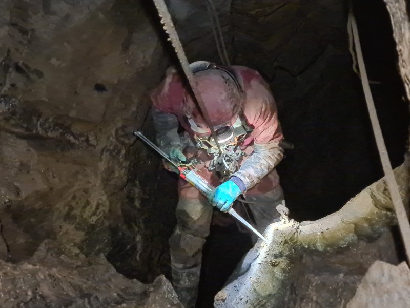
At the rebelay on second pitch, Gareth completely threw me with a really tight rig while trying to maintain the proposed rope length for the pitch, which nearly hung me up as I tried to change onto the bolt traverse, so I adjusted the rope length requirements on the survey accordingly. At the big pitch, Joel's old ropes and stressed hangers, which were nearly 15 years old and very tired indeed, put me off completely. Gareth swung out onto the pitch, and I failed to follow, so he installed the anchors alone, and I did not collect any helpful photographs of the new arrangement. For 2 hours, Gareth meticulously cleaned the bolt holes, dried them, filled them with resin, inserted the new P-hangers, and cleaned off the excess resin to leave a good finish. That is a very long time to hang on the same rope, but he barely seemed to notice the time. I pretended to be useful, taking more pictures of the new hangers at the pitch head, which could be used to update the survey, and hauling gear out of the cave when Gareth returned.
Gareth removed Joel's bolts from the traverse, and I took the traverse rope home. I washed off the mud cake, and revealed that the rope was in surprisingly good condition. The maillons that had already failed our inspection, however, were terrible. One of them was mostly worn through from rubbing against the hanger, to the point that it could be permanently deformed with just finger strength. The other two were also severely worn. People had been hanging their lives on them like that. However, when they were sent for testing, the worst one had actually lost only 14% of its expected strength when pulled realistically on a hanger, and held well over 2 tonnes before it broke. A few days later, Gareth, John and James Waite tested out the new bolts, and removed most of Joel's old ropes from the pitch. James also derigged the even older rope from the crazy bolt traverse over the first pitch. They brought the big pitch ropes back to me, so we could measure the lengths correctly. John had taken several pictures of the new bolts, so that I could work out most of their new positions.
The bad news that day, however, was that Caving Wales had requested a simple topo in return for permission to bolt the cave, and they wanted one that focused only on their maintained equipment. They suggested a style they were used to publishing, some of which were proper topos like ours (the type commonly used in northern England), and others of which very basic sketches. As it happens, I had based our style on one of the popular versions used in Northern England, so we should be good there. (I also added a series of instructions for these on the Therion wiki, and the MetaPost code for the symbols is open source.) There was also a request from some other relatively inexperienced cavers to have only the main 2 routes on the topo.
I will be quite blunt here; I detest, with a passion, this drive to dumb down topos or surveys to the point that they no longer represent the cave, or so that they only show a major route, like the rest of the cave and its routes do not exist. This is not an early map with "Here Be Dragons" written wherever the explorer has not yet trodden, and this is not TikTok where people cannot cope with more than 60 seconds of misinformation before their brains get too full. I know some people like it, but this is not a one-size-fits-all, and we should be allowed to have much better topos, and we should be allowed to have proper surveys. While I would understand that it can be hard to navigate with several passages stacked on top of each other, that is not relevant here, since our complete topo actually feels very clean and easy to use, and there are no overlaps obscuring any of the rigging along the main routes. Cavers regularly, frequently in fact, use surveys that show more than one passage, and they follow the one they are following, ignoring what they do not need today. There really is no need to reduce it further. What I hated most, was the thought that they would want to publish something that people would find most easily on the Caving Wales website, ending up assuming this was the main topo of the cave, and never realise just how much more cave existed. Our years of work would be for nothing. This left me feeling incredibly insulted, and upset me to the point that I was ready to abandon all of the work we had done.
But in spite of feeling like I was throwing my own work away, I reworked the rigging topo so that it could be separated into only maintained routes, and the full topo, something not as easy as it sounds, since the ropes need to be layered on top of each other in the correct orders, to have the correct ropes showing in front where needed. In most cases, this needed every relevant Therion scrap to be split into three scraps, for the different rope layers. I made a version that would export just the maintained routes. However, at the same time, I wanted to encourage cavers to see the whole survey, not to paint themselves into the box of 1947 again. So every optional passage was put into its own scrap and removed, saying to see the full topo to see them. They really are everywhere, reminding cavers that they are missing most of the cave by sticking only to the routes that Caving Wales have adopted. But since cavers might end up downloading the topo from Caving Wales, I wanted to try to force them to offer the full topo at the same time as the partial one. So I worked out how to bundle them into the same survey file, so downloading one would download the other, but so that cavers could easily choose which page to print after downloading it.
It took a few days to work out how to do that cleanly, because Therion cannot do it natively, and creating cross platform code using external utilities in Therion is surprisingly hard without manual editing of commands for each platform. But with it now working, it became very clear that this would also be a great way to release the entire survey. Until now, we had a plan survey, an exploded plan survey, an overview, an elevation and rigging topo, and now a rigging topo for the main routes. Cavers would not know which one to download, and would end up downloading only one part while missing the others. It made complete sense to combine them into a single PDF, so that all versions could be downloaded together. So much sense, in fact, that this should be the main way we would distribute it. So the Pwll Dwfn book of surveys was born.
I finished updating all the bolt positions, and tidying up the Therion files. With that, the survey was once again done, but now with the new rig. Completed on the 19th of January 2025, it was finally ready to be put onto mugs, T-shirts and posters, and Gareth could now call Pwll Dwfn "complete", whatever that means. The resulting section of my website, which included a gallery overlaid on the survey, was ready on the 23rd of January 2025. It went live on the 27th.
The survey had taken 15 underground surveying trips in Pwll Dwfn, 1 climbing trip, 5 surface surveys, 4 attempts to fix the location, and 2 trips to survey the digs, for a total of 24 days on site for me, and 21 for Gareth. If this had been a more simple, horizontal cave, a survey of that standard might have taken just 2 trips! We had worked together for 60 evenings (about 175 hours in total), with me easily exceeding triple that with the work afterwards. The rebolting work had taken a further 4 trips for Gareth, and 1 for me. While we hope you like the results, I fully expect someone to complain that the rigging topo does not exactly match Dave Elliot's style, and that the plan would have looked better with the passages just approximated for clarity, or that there should have been cross sections crammed somehow onto the insanity of a survey. Yes, maybe there should. Thanks for volunteering.
Pwll Dwfn's survey took 4110 Disto readings (1 per splay, 3 per leg in most cases), using 191 legs, 9 of which were forced from a single reading, 21 of which were marked as duplicate, 2 of which were both duplicate and forced from a single reading. The surveyed length would have been 72 metres longer if the legs were not marked as duplicate. The surface survey took 1118 readings. The overall survey, surface and caves, is almost exactly 1300 metres long, and took over 5300 readings. Many additional readings were used for calibration, and parts of the survey that were abandoned.
The choice of licence is always a tough one. Every surveyor wants their survey to be the definitive one that people respect. A great many surveyors hope that their survey can be printed on paper, mugs and T-shirts, and bring in a little bit of money for their club.
But a good survey often ends up rotting in a drawer somewhere, because it is no longer in print, and the surveyors can no longer be contacted to ask for permission to re-print it. It cannot be included in a book either. Clubs can be contacted, but many clubs cannot in fact own copyright for a survey (but that does not stop people from assuming they can). Even if they can, unless the surveyor gives that club the right to grant other people usage rights over the survey (essentially making a contract with the club to allow it), the club cannot authorise its use in books.
And some clubs do not like to give away the data or source of their surveys, even though surveys are not exactly a money spinner, typically costing the same as the paper they are printed on. A survey cannot live on unless it is licensed to allow other people to build on it - they are all forced to start from scratch, unless they happen to be able to work out which people have inherited the copyright from the authors who are no longer alive, and get their permission to use it. Without a licence, explicit permission must be sought from each and every copyright holder before publication can happen. That means a verbal or written contract. And any single copyright holder can say no.
A great many surveys now use open source licences, but in South Wales this is uncommon. The legacy of this is the very reason that we do not have surveys of certain caves available for purchase, because the surveyors had not agreed to release them under a formal licence.
We want this survey to live on. It is open source, under CC BY 4.0. The licence choice allows book authors to use it without having to find the copyright owners later. The licence intentionally is not viral/copyleft, because it allows it to be combined in a work (such as a book) with other content that is under a different licence. However, if you would like to buy a printed copy, SWCC have been asked to sell it. Enjoy.
| Source | Grid reference | Altitude | Horizontal error (m) | Vertical error (m) | Notes | |||
|---|---|---|---|---|---|---|---|---|
| Our filtered NRTK result 2022 | SN | 83319.170 | 16484.670 | 397.250 | ±0.0417 | ±0.0422 | Used to calculate other errors | |
| Caves of South Wales 1995 | SN | 8340 | 1650 | 399 | 82.27 | +1.75 | ||
| Old Cambrian 2000 | SN | 8340 | 1650 | 82.27 | ||||
| Cambrian 2022 | SN | 83322 | 16491 | 398 | 6.93 | +0.75 | ||
| ogof.org.uk 2022 | SN | 83322 | 16491 | 398 | 6.93 | +0.75 | ||
| Meithrin Mynydd 1997 | SN | 83320 | 16481 | 403 | 3.76 | +5.75 | ||
| Ordnance Survey 1:25K 2022 | SN | 83300 | 16410 | 401 | 77.09 | +3.75 | ||
| Google Earth 2021 | SN | 83319.701 | 16483.821 | 399 | 1.00 | +1.75 | ||
| Wessex Cave Club 1947 | SN | 83310.980 | 16544.601 | 396.24 | 60.49 | -1.01 | 51°50'5.5"N, 3°41'37.5"W Airy 1830 | |
| Craven Pothole Club 1962 | SN | 83 | 16 | 405.384 | +8.13 | |||
| OpenStreetMap 2022 | SN | 83321.874 | 16498.235 | 398 | 13.83 | +0.75 | ||
| Our abandoned average 2020 | Weighted | SN | 83319.84 | 16486.59 | 397.92 | 2.03 | +0.67 | |
| Set 1 | SN | 83320.02 | 16486.79 | 397.41 | 2.28 | +0.16 | ||
| Set 2 | SN | 83319.98 | 16486.96 | 397.98 | 2.43 | +0.73 | ||
| Set 3 | SN | 83319.74 | 16486.29 | 398.31 | 1.72 | +1.06 | ||
| Set 4 | SN | 83319.63 | 16486.40 | 398.15 | 1.79 | +0.90 | ||