 Pwll Dwfn surveys: plan, exploded plan, elevation, rigging topos, overview.
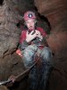 Story of the survey; how the survey was made.
This is the official distribution site for the Pwll Dwfn survey, run by one of the surveyors. Surveys are produced in PDF format. A PDF viewer will be required if your system does not already have one, such as Foxit Reader or Adobe Reader. If you are using a modern web browser on a computer, it can probably view PDFs directly. Choose from one of the following:
Pwll Dwfn surveys: plan, exploded plan, elevation, rigging topos, overview. Story of the survey; how the survey was made.Choose from one of the following:
 Loch 3D rendering of Pwll Dwfn (for use with Therion Loch).
 Survex 3D rendering of the Pwll Dwfn survey data (for use with Survex Aven).
 KML rendering of Pwll Dwfn (for use with Google Earth Pro). NB. Mispositioned by 0.9 metres southwest due to Therion using Helmert approximate conversion to GPS. Google Earth satellite images are also randomly mispositioned.
 KML rendering of the Pwll Dwfn survey data (for use with Google Earth Pro). NB. Mispositioned by 0.9 metres southwest due to Therion using Helmert approximate conversion to GPS. Google Earth satellite images are also randomly mispositioned.
The survey data and completed surveys are available under open source licences. If you are a developer, and you wanted to work on the Therion or Survex source code of the survey, you can download the survey source. The source also contains a few other versions of the survey, such as minimal versions for printing in magazines, or DXF versions for use with embedding in AutoCAD-based surveys. Licensing information is contained in LICENCE.txt within that package. Please get in touch if you need clarifications.
 Complete Pwll Dwfn description, including the optional extras
 Our complete Pwll Dwfn picture gallery, placed over the survey
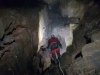 Our complete Pwll Dwfn basic picture gallery
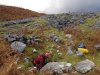 Our complete Pwll Dwfn surface picture gallery
The cave is located on the Black Mountain in South Wales. Its national grid reference is:
GPS coordinates change by 2.5 cm every year, because of continental drift, but in January 2025, its GPS coordinates were: